METAR & TAF 5C1
Current METAR
Observed 13:15Z
K5C1 271315Z AUTO 19006KT 10SM BKN007 BKN011 23/23 A3003 RMK AO1
- Wind
- 190° @ 6 kt
- Visibility
- 10 SM
- Temp / Dew
- 23°C / 23°C
- Altimeter
- 30.03 inHg
- Clouds
- BKN
- Density alt
- 2,540 ft
- Ceiling
- 700 ft AGL
- Rules
- IFR
Airport info & contacts
Manager on record, flight service, ARTCC, attendance schedule and pattern altitude — published by the FAA and refreshed every 28 days.
Location
- From city
- 20 NM NW
- VFR sectional
- SAN ANTONIO
- ARTCC
- ZHU · HOUSTON
- NOTAM facility
- SJT (NOTAM-D)
Airport manager
- Name
- KELBY COMBS
- Phone
- 337-258-8387
- Address
- 400 BOERNE STAGE AIRFIELD, BOERNE TX 78006
Flight service · Hours
- FSS SJT
- SAN ANGELO1-800-WX-BRIEF
- Attendance
- 0800-1700
Frequencies
Tap any row to copy the frequency to your clipboard.
Runways & pattern
Full pagePattern entry · RWY 17
RIGHT TRAFFICRunway end performance
| End | TORA | TODA | ASDA | LDA | VGSI | Approach lights | Obstruction |
|---|---|---|---|---|---|---|---|
| 17 | — | — | — | — | — | — | 8', fence, 201' from thr, 0' R of cntrln, slope 0 |
| 35 | — | — | — | — | — | — | 25', trees, 201' from thr, 82' R of cntrln, slope 0 |
Declared distances in feet. TORA = takeoff run available, TODA = takeoff distance, ASDA = accelerate-stop, LDA = landing distance.
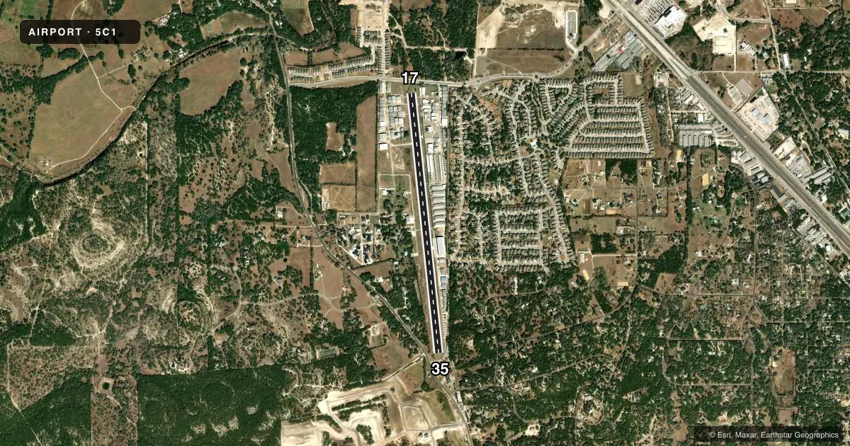
Airport sketch
Runways drawn to scale from FAA survey coordinates, rendered over satellite imagery. Not for navigation.
Approaches & charts
Services on the field
Fuel grades, oxygen, maintenance, ramp storage and lighting — as declared to the FAA by the airport operator.
Fuel & services
- Fuel
- 100LLA
- Oxygen (bottled)
- Low pressure
- Airframe repair
- Major
- Power plant repair
- Major
- Other services
- GLD,INSTR,RNTL,TOW
Ramp & ground
- Transient storage
- Tie-down
- Hangar
- Lighting schedule
- SS-SR
- Beacon schedule
- SS-SR
- Beacon
- White / Green (civil land)(WG)
- Wind indicator
- Lighted
- Segmented circle
- Yes
Fuel & FBOs
Cheapest 100LL and Jet A on the field and nearby. Always confirm with the FBO before taxi.
Airport notes
Surface conditions, obstructions, local procedures, lighting outages and other notes published with each FAA cycle.
General notes
- NOISE ABATEMENT PROCEDURES IN EFFECT CTC AMGR.
- NO TGLS, STOP & GO OR LOW APCHS.
- GLIDER ACT ON & INVOF ARPT.
- ALL LNDG TURBINE ACFT MUST BE STAGE 3 OR BETTER.
- RWY 35, 35 FT LGTD PWR POLES ACRS APCH.
- FOR CD CTC SAN ANTONIO APCH AT 210-805-5516.
- USE EXTREME CTN WHEN OPRG INTO AND OUT OF 5C1 FOR OVER FLIGHT TFC LDG SAN ANTONIO INTL (KSAT) AT 3000 FT MSL AND ABV. SEE LTA-SAT-32.
- LANDING FEES IN EFFECT
Approach & departure obstructions
- 178 FT FENCE,187 FT DSTC,82 FT R,30 FT LGTD PLINE, 152195 FT DSTC,82 FT R.
- 358 FT FENCE, 38 FT DSTC, 0 FT BOTH; 30 FT TREE, 40 FT DSTC, 75 FT L; 35 FT POLE LINE, 0-199 FT DSTC, 143 FT R, LGTD.
- 17APCH SLOPE 2:1 AT DSPLCD THR, 18 FT TANK, 44 FT DSTC, 190 FT R.
- 35APCH SLOPE 0:1 AT DSPLCD THR OVR 24 FT HNGR, 0 FT DSTC, 204 FT R.
Other notes
- UNICOM UNMNT.
- MANAGER5C1.KELBY@GMAIL.COM
VFR map & nearby airports
VFR sectional. Tap any ICAO chip to open that airport.
Key facts · 5C1
Answer card- ICAO
- 5C1
- Name
- BOERNE STAGE AIRFIELD
- Location
- SAN ANTONIO, TEXAS
- Elevation
- 1,383.9 ft MSL
- Traffic pattern altitude
- 2,383.9 ft MSL (1,000 AGL)
- Control tower
- Non-towered (use CTAF)
- Total runways
- 1
- Longest runway
- 17/35 · 5,006 ft
- Published ILS approaches
- 0
- Published frequencies
- 4
- Magnetic variation
- 5°
- Current flight rules
- IFR
- Current wind
- 190° at 6 kt
- Favored runway now
- RWY 17
Boerne Stage Airfield (5C1) sits in San Antonio, Texas. Field elevation is 1,383.9 ft MSL. The airport has one runway. Runway 17/35 is 5,006 ft long with asphalt pavement. There is no control tower. UNICOM is unmonitored. CTAF and UNICOM are both listed on 123.0. No ILS approaches are published.
Pattern altitude is not published. Use the standard 1,000 ft AGL for light piston operations unless the current Chart Supplement says otherwise. The on-field FBO is Boerne Stage Airfield. It carries 100LL and Jet A with Prist. Call (830) 981-2345 for current service details.
The published remarks matter here. Runway 35 has lighted power poles across the approach. There are also fences, power lines, a tree and a hangar near the runway ends. No touch-and-go, stop-and-go, or low approaches are permitted. Landing fees are in effect. Glider activity is on and near the airport. Use extra caution with overflight traffic arriving into San Antonio International at 3,000 ft MSL and above. This is a field where a careful arrival brief pays off. Check the current Chart Supplement for the latest restrictions before you go.