METAR & TAF 1T8
1T8 does not publish a METAR.
Showing the nearest reporting station: KSAT (SAN ANTONIO INTL) · 12.4 NM away. Conditions at 1T8 may differ.
METAR · KSAT
Observed 09:51Z
KSAT 270951Z 16007KT 10SM CLR 25/23 A2999 RMK AO2 SLP136 T02500228 $
- Wind
- 160° @ 7 kt
- Visibility
- 10 SM
- Temp / Dew
- 25°C / 23°C
- Altimeter
- 29.99 inHg
- Clouds
- CLR
- Density alt
- 2,462 ft
- Ceiling
- Unlimited
- Rules
- VFR
Airport info & contacts
Manager on record, flight service, ARTCC, attendance schedule and pattern altitude — published by the FAA and refreshed every 28 days.
Location
- From city
- 16 NM N
- VFR sectional
- SAN ANTONIO
- ARTCC
- ZHU · HOUSTON
- NOTAM facility
- SJT (NOTAM-D)
Airport manager
- Name
- DANA ANDERSON
- Phone
- 210-275-4970
- Address
- 29890 BULVERDE LN #27, BULVERDE TX 78163
Flight service · Hours
- FSS SJT
- SAN ANGELO1-800-WX-BRIEF
- Attendance
- 0900-1700
Frequencies
Tap any row to copy the frequency to your clipboard.
Runways & pattern
Full pagePattern entry · RWY 17
RIGHT TRAFFICRunway end performance
| End | TORA | TODA | ASDA | LDA | VGSI | Approach lights | Obstruction |
|---|---|---|---|---|---|---|---|
| 17 | — | — | — | — | — | — | 40', pline, 200' from thr, 125' R of cntrln, slope 0 |
| 35 | — | — | — | — | — | — | 30', trees, 200' from thr, 125' R of cntrln, slope 0 |
Declared distances in feet. TORA = takeoff run available, TODA = takeoff distance, ASDA = accelerate-stop, LDA = landing distance.
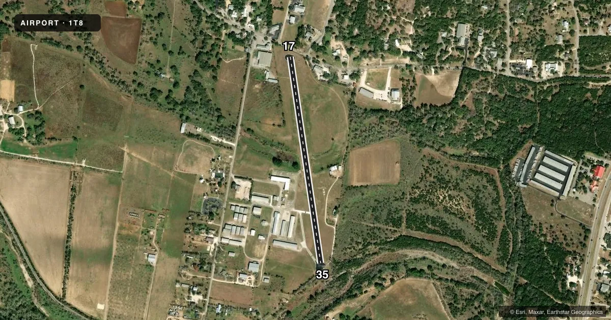
Airport sketch
Runways drawn to scale from FAA survey coordinates, rendered over satellite imagery. Not for navigation.
Approaches & charts
Services on the field
Fuel grades, oxygen, maintenance, ramp storage and lighting — as declared to the FAA by the airport operator.
Fuel & services
- Fuel
- 100LL
- Airframe repair
- Major
- Power plant repair
- Major
- Other services
- AVNCS,INSTR,RNTL
Ramp & ground
- Transient storage
- Tie-down
- Hangar
- Landing fee
- No fee published
- Lighting schedule
- SEE RMK
- Beacon schedule
- SEE RMK
- Beacon
- White / Green (civil land)(WG)
- Wind indicator
- Yes
- Segmented circle
- Yes
Fuel & FBOs
Cheapest 100LL and Jet A on the field and nearby. Always confirm with the FBO before taxi.
Airport notes
Surface conditions, obstructions, local procedures, lighting outages and other notes published with each FAA cycle.
General notes
- NOISE ABATEMENT PROCS IN EFCT CTC AMGR 830-438-4359 OR 210-240-1365.
- TOUCH & GO, STOP & GO, AND LOW APPROACHES PROHIBITED.
- DEER ON OR IN INVOF ARPT.
- RWY 17 ALL TRAFFIC RIGHT HAND.
- FOR CD CTC SAN ANTONIO APCH AT 210-805-5516.
- USE EXTREME CTN FOR MIL ACFT FROM RANDOLPH AFB AT OR ABV 3000 FT MSL MON-FRI 0800-2200 AND WHEN TWR HRS EXTD BY NOTAM, OCNL SAT AND SUN.
- HEL EXPERTS ADJ CTC AT 210-930-0125 OR 210-501-3111.
- HEL SKID LDG PROHIBITED ON PAVEMENT.
Lighting notes
- DUSK-2200.
- SS-SR ACTVT LIRL RY 16/34 - CTAF.
Fuel notes
- 100LL24 HR SELF SERVE FUEL.
Runway surface & condition
- 17/35NSTD LIRL; ONLY CNTR 2600 FT LGTD.
Approach & departure obstructions
- 1735 FT TREES 180 FT DSTC.
- 3536 FT TREES, 110 FT DSTC.
- 17NO DISPLACED THRESHOLD MARKINGS
- 35NO DISPLACED THRESHOLD MARKINGS.
- 17DSPLCD THR NOT LIGHTED.
- 35DSPLCD THR NOT LIGHTED.
- 17UNABLE TO DETERMINE APCH SLOPE TO DSPLCD THR DUE DSPLCD THR NOT MARKED.
- 35UNABLE TO DETERMINE APCH SLOPE TO DSPLCD THR DUE DSPLCD THR NOT MARKED.
Other notes
- MANAGERALSO 210-240-1365 MARKLINE@GVTC.COM. ALSO 830-438-4359 OR 210-240-1365.
VFR map & nearby airports
VFR sectional. Tap any ICAO chip to open that airport.
Key facts · 1T8
Answer card- ICAO
- 1T8
- Name
- BULVERDE AIRPARK
- Location
- SAN ANTONIO, TEXAS
- Elevation
- 1,088 ft MSL
- Traffic pattern altitude
- 2,088 ft MSL (1,000 AGL)
- Control tower
- Non-towered (use CTAF)
- Total runways
- 1
- Longest runway
- 17/35 · 2,783 ft
- Published ILS approaches
- 0
- Published frequencies
- 2
- Magnetic variation
- 7°
- Current flight rules
- VFR
- Current wind
- 160° at 7 kt
- Favored runway now
- RWY 17
Bulverde Airpark sits in San Antonio, Texas at 1,088 ft MSL. It has one asphalt runway. The longest runway is 17/35 at 2,783 ft. There is no control tower. CTAF and UNICOM are both 122.8. No ILS approaches are published. Pattern altitude is not published, so verify the current traffic pattern in the FAA Chart Supplement before you go. The airport is in a busy part of the San Antonio area. Expect to stay alert for traffic and for military aircraft from Randolph Air Force Base in the area, especially on weekdays and when tower hours are extended by NOTAM. Deer are also reported on or near the airport.
Anderson Aviation is on the field. It carries 100LL. Fuel is available 24 hours as self-serve with a major credit card. The beacon operates from dusk to 2200. Runway 17 has several close-in obstructions, including a fence, a road, trees and power poles near the threshold. Runway 35 also has trees near the threshold. Runway 17 has a published 19 to 1 approach slope to the displaced threshold because of a power line near the approach path. Helicopter skid landing is prohibited on runway 17/35. If you are planning a first stop here, brief the runway environment carefully. Check the current FAA Chart Supplement for any updated operational notes before departure.