METAR & TAF 1T7
1T7 does not publish a METAR.
Showing the nearest reporting station: KSAT (SAN ANTONIO INTL) · 16.8 NM away. Conditions at 1T7 may differ.
METAR · KSAT
Observed 13:36Z
KSAT 271336Z 17008KT 10SM BKN015 BKN250 26/22 A3000 RMK AO2 T02560222
- Wind
- 170° @ 8 kt
- Visibility
- 10 SM
- Temp / Dew
- 26°C / 22°C
- Altimeter
- 30.00 inHg
- Clouds
- BKN
- Density alt
- 2,784 ft
- Ceiling
- 1,500 ft AGL
- Rules
- MVFR
Airport info & contacts
Manager on record, flight service, ARTCC, attendance schedule and pattern altitude — published by the FAA and refreshed every 28 days.
Location
- From city
- 23 NM N
- VFR sectional
- SAN ANTONIO
- ARTCC
- ZHU · HOUSTON
- NOTAM facility
- SJT (NOTAM-D)
Airport manager
- Name
- BRIAN LLOYD
- Phone
- 210-504-8992
- Address
- 354 FLIGHTLINE, SPRING BRANCH TX 78070
Flight service · Hours
- FSS SJT
- SAN ANGELO1-800-WX-BRIEF
- Attendance
- ALL
Frequencies
Tap any row to copy the frequency to your clipboard.
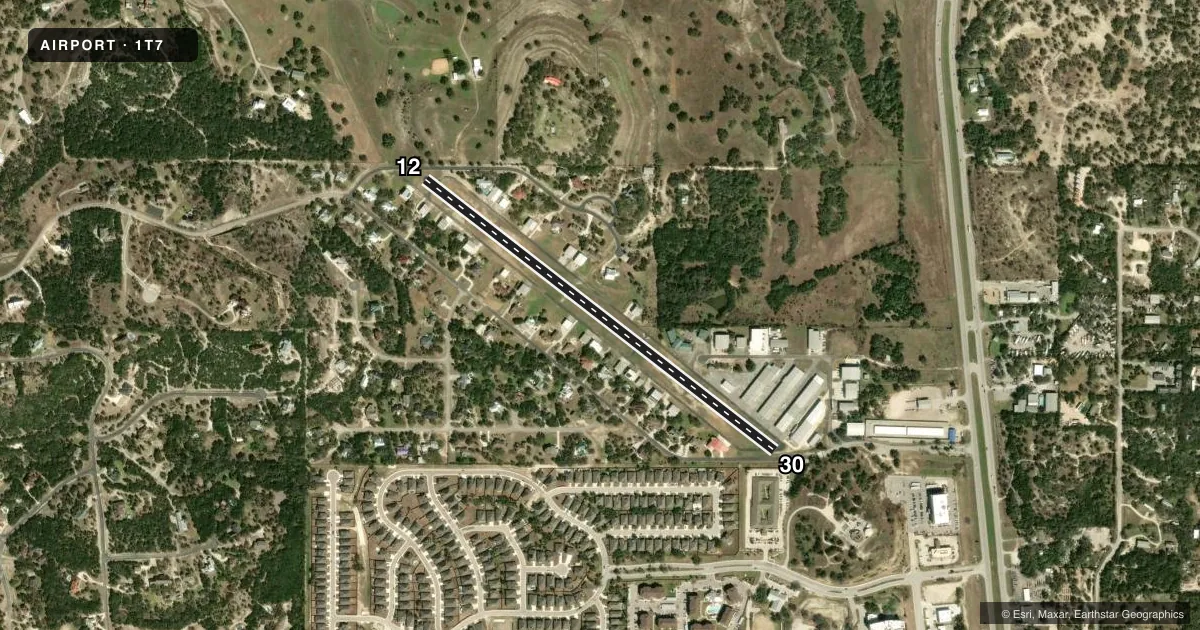
Runways & pattern
Full pagePattern entry · RWY 12
LEFT TRAFFICRunway end performance
| End | TORA | TODA | ASDA | LDA | VGSI | Approach lights | Obstruction |
|---|---|---|---|---|---|---|---|
| 12 | — | — | — | — | — | — | 15', trees, 300' from thr, 30' R of cntrln, slope 6 |
| 30 | — | — | — | — | — | — | 15', road, 200' from thr, 125' R of cntrln, slope 0 |
Declared distances in feet. TORA = takeoff run available, TODA = takeoff distance, ASDA = accelerate-stop, LDA = landing distance.
Airport sketch
Runways drawn to scale from FAA survey coordinates, rendered over satellite imagery. Not for navigation.
Approaches & charts
Services on the field
Fuel grades, oxygen, maintenance, ramp storage and lighting — as declared to the FAA by the airport operator.
Fuel & services
- Fuel
- 100LL
- Oxygen (bulk)
- High pressure
- Airframe repair
- Major
- Power plant repair
- Major
- Other services
- INSTR,RNTL,SALES
Ramp & ground
- Transient storage
- Tie-down
- Lighting schedule
- SS-SR
- Wind indicator
- Lighted
- Segmented circle
- Yes
Fuel & FBOs
Cheapest 100LL and Jet A on the field and nearby. Always confirm with the FBO before taxi.
Airport notes
Surface conditions, obstructions, local procedures, lighting outages and other notes published with each FAA cycle.
General notes
- TGL AND LOW APCHS PROHIBITED FOR TRAN & COML ACFT. TKOFS RSTRD BTN 2200-0600.
- HEL TRNG OPS PROHIBITED.
- FOR CD CTC SAN ANTONIO APCH AT 210-805-5516.
- USE EXTREME CTN FOR MIL ACFT FROM RANDOLPH AFB AT OR ABV 3000 FT MSL MON-FRI 1600-0600Z++ AND WHEN TWR HRS EXTD BY NOTAM, OCNL SAT AND SUN.
- RWY 12 120' RISING TERRAIN 0.4 MI NW OF RWY END. NSTD AIMING POINT MKGS AT 500 FT, 2490 FT REMAINING.
- RWY 12 CALM WIND RWY.
- RWY 12/30 NOW MARKED AS 13/31
- RWY 30 NSTD AIMING POINT MKGS AT 300 FT.
- DEER ON & INVOF RWY.
Fuel notes
- 100LLSELF SERV FUEL. FOR ASSISTANCE CALL 830-522-1885.
Runway surface & condition
- 12/30RWY 30 RISES RAPIDLY AT NORTH END. 12 END 49 FT HIGHER THAN 30 END.
Approach & departure obstructions
- 1215 FT RD 0 FT DSTC 65 FT L; 30 FT TREE 80 FT DSTC, 45 FT L.
- 3015 FT RD 0 FT DSTC 67 FT L.
Other notes
- PRVDD RIGHT HAND TFC IS USED FOR RWY 30 DUE TO RAPID RISING TRRN WEST OF RWYS.
VFR map & nearby airports
VFR sectional. Tap any ICAO chip to open that airport.
Key facts · 1T7
Answer card- ICAO
- 1T7
- Name
- KESTREL AIRPARK
- Location
- SAN ANTONIO, TEXAS
- Elevation
- 1,261 ft MSL
- Traffic pattern altitude
- 2,261 ft MSL (1,000 AGL)
- Control tower
- Non-towered (use CTAF)
- Total runways
- 1
- Longest runway
- 12/30 · 3,000 ft
- Published ILS approaches
- 0
- Published frequencies
- 2
- Magnetic variation
- 7°
- Current flight rules
- MVFR
- Current wind
- 170° at 8 kt
- Favored runway now
- RWY 12
Kestrel Airpark sits in San Antonio, Texas at 1,261 ft MSL. It has one asphalt runway, 12/30, at 3,000 ft. There is no control tower. CTAF and UNICOM are both 122.975. No ILS approaches are published, so plan with that in mind if the weather is marginal.
The published pattern altitude is not listed. Use the standard 1,000 ft AGL pattern unless the current Chart Supplement says otherwise. Aloha Aviation Services is on the field. It carries 100LL. Self-serve fuel is available. Call 830-522-1885 for assistance if needed.
This is a field where the remarks matter. Military traffic from Randolph Air Force Base can be a factor at or above 3,000 ft MSL during the published weekday window. Some weekends also see extended tower hours by NOTAM. Touch-and-goes and low approaches are prohibited for training and commercial aircraft. Helicopter training is also prohibited. Takeoffs are restricted between 2200 and 0600. Runway 30 uses right-hand traffic because terrain rises quickly west of the runway. Runway 12 has rising terrain northwest of the end. Deer are reported on and near the runway. For clearance delivery, contact San Antonio Approach at 210-805-5516 before departure.