METAR & TAF E70
E70 does not publish a METAR.
Showing the nearest reporting station: KBAZ (NEW BRAUNFELS NTL) · 6.8 NM away. Conditions at E70 may differ.
METAR · KBAZ
Observed 11:51Z
KBAZ 271151Z 17004KT 8SM CLR 23/22 A2997 RMK AO2 SLP138 T02280222 10261 20222 58001
- Wind
- 170° @ 4 kt
- Visibility
- 8 SM
- Temp / Dew
- 23°C / 22°C
- Altimeter
- 29.97 inHg
- Clouds
- CLR
- Density alt
- 1,587 ft
- Ceiling
- Unlimited
- Rules
- VFR
Airport info & contacts
Manager on record, flight service, ARTCC, attendance schedule and pattern altitude — published by the FAA and refreshed every 28 days.
Location
- From city
- 2 NM NW
- VFR sectional
- SAN ANTONIO
- ARTCC
- ZHU · HOUSTON
- NOTAM facility
- SJT (NOTAM-D)
Airport manager
- Name
- DERRICK SMITH
- Phone
- 830-379-9800
- Address
- 509 BEECHCRAFT LN, SEGUIN TX 78155
Flight service · Hours
- FSS SJT
- SAN ANGELO1-800-WX-BRIEF
- Attendance
- MON-FRI · 0800-1700
Frequencies
Tap any row to copy the frequency to your clipboard.
Runways & pattern
Full pagePattern entry · RWY 18
LEFT TRAFFICRunway end performance
| End | TORA | TODA | ASDA | LDA | VGSI | Approach lights | Obstruction |
|---|---|---|---|---|---|---|---|
| 18 | — | — | — | — | — | — | 8', other, 208' from thr, 15' R of cntrln, slope 1 |
Declared distances in feet. TORA = takeoff run available, TODA = takeoff distance, ASDA = accelerate-stop, LDA = landing distance.
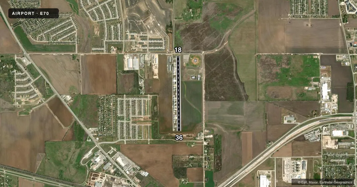
Airport sketch
Runways drawn to scale from FAA survey coordinates, rendered over satellite imagery. Not for navigation.
Approaches & charts
Services on the field
Fuel grades, oxygen, maintenance, ramp storage and lighting — as declared to the FAA by the airport operator.
Fuel & services
- Fuel
- 100LL
- Other services
- INSTR,RNTL
Ramp & ground
- Transient storage
- Not published
- Landing fee
- No fee published
- Lighting schedule
- SEE RMK
- Beacon schedule
- SS-SR
- Beacon
- White / Green (civil land)(WG)
- Wind indicator
- Yes
- Segmented circle
- No
Fuel & FBOs
Cheapest 100LL and Jet A on the field and nearby. Always confirm with the FBO before taxi.
Airport notes
Surface conditions, obstructions, local procedures, lighting outages and other notes published with each FAA cycle.
General notes
- FOR CD CTC SAN ANTONIO APCH AT 210-805-5516.
- 10 FT DITCH PARALLEL TO RWY FULL LENGTH, 125 E OF RWY CL AND ACROSS RWY 36 END, 140 FT DSTC, 125 FT. L/R ACRS APCH.
Lighting notes
- ACTVT LIRL RWY 18/36 - CTAF.
Fuel notes
- 100LLFUEL SELF-SERVE.
Runway surface & condition
- 18/36ONLY CNTR 3285 FT LGTD.
Approach & departure obstructions
- 1818 FT RD, 125 FT DSTC, 125 FT L/R.
- 36RWY 36, 7 FT CROPS 0-199 FT DSTC, ACRS APCH, SEASONAL.
- 18CONCRETE BRIDGE WALL.
Other notes
- MANAGEROR 619-228-5885 MGR CELL. DERRICK@VERACITYAVIATION.COM
VFR map & nearby airports
VFR sectional. Tap any ICAO chip to open that airport.
Key facts · E70
Answer card- ICAO
- E70
- Name
- HUBER AIRPARK CIVIC CLUB LLC
- Location
- SEGUIN, TEXAS
- Elevation
- 556 ft MSL
- Traffic pattern altitude
- 1,556 ft MSL (1,000 AGL)
- Control tower
- Non-towered (use CTAF)
- Total runways
- 1
- Longest runway
- 18/36 · 3,415 ft
- Published ILS approaches
- 0
- Published frequencies
- 1
- Magnetic variation
- 6°
- Current flight rules
- VFR
- Current wind
- 170° at 4 kt
- Favored runway now
- RWY 18
Huber Airpark Civic Club LLC sits in Seguin, Texas. Field elevation is 556 ft MSL. The airport has one runway, 18/36, at 3,415 ft asphalt. There is no control tower. CTAF is 122.9. No ILS approaches are published here.
Pattern altitude is not published. Use the standard 1,000 ft AGL for light piston traffic unless the current Chart Supplement says otherwise. Runway 18/36 has low intensity lights that are activated by CTAF. Only the center 3,285 ft is lighted. Published remarks also call out seasonal crops near the approach to runway 36. Runway 18 has a fence and a road across the approach path. That makes a close look at the current remarks smart before you go.
Veracity Aviation is on the field. It carries self-serve 100LL. If you need clearance delivery, San Antonio Approach is listed in the remarks. This is a non-towered field with a single runway, so plan your arrival. Make your calls early. Stay sharp on the approach end details. The runway magnetic bearings are 174 degrees for runway 18 and 354 degrees for runway 36. That is useful when you are lining up in light winds or at night.