METAR & TAF 74R
74R does not publish a METAR.
Showing the nearest reporting station: KSSF (STINSON MUNI) · 3.5 NM away. Conditions at 74R may differ.
METAR · KSSF
Observed 12:34Z
KSSF 271234Z 13004KT 10SM BKN013 24/23 A2996 RMK AO2 T02440228 PNO $
- Wind
- 130° @ 4 kt
- Visibility
- 10 SM
- Temp / Dew
- 24°C / 23°C
- Altimeter
- 29.96 inHg
- Clouds
- BKN
- Density alt
- 1,714 ft
- Ceiling
- 1,300 ft AGL
- Rules
- MVFR
Airport info & contacts
Manager on record, flight service, ARTCC, attendance schedule and pattern altitude — published by the FAA and refreshed every 28 days.
Location
- From city
- 9 NM S
- VFR sectional
- SAN ANTONIO
- ARTCC
- ZHU · HOUSTON
- NOTAM facility
- SJT (NOTAM-D)
Airport manager
- Name
- JOHN NIX
- Phone
- 210-748-8672
- Address
- 13680 PLEASANTON RD., SAN ANTONIO TX 78221
Flight service · Hours
- FSS SJT
- SAN ANGELO1-800-WX-BRIEF
- Attendance
- UNATTND
Frequencies
Tap any row to copy the frequency to your clipboard.
Runways & pattern
Full pagePattern entry · RWY 11
LEFT TRAFFIC| Runway | Heading (°M) | Length | Surface | Traffic |
|---|---|---|---|---|
| 11/29Favored | 110° / 290° | 2,360 ft | TURF | Standard L |
| 16/34 | 156° / 336° | 2,250 ft | TURF | Standard L |
Runway end performance
| End | TORA | TODA | ASDA | LDA | VGSI | Approach lights | Obstruction |
|---|---|---|---|---|---|---|---|
| 11 | — | — | — | — | — | — | 30', trees, 0' from thr, 0' R of cntrln, slope 0 |
| 29 | — | — | — | — | — | — | 30', trees, 0' from thr, 0' R of cntrln, slope 0 |
| 16 | — | — | — | — | — | — | 40', trees, 0' from thr, 0' R of cntrln, slope 0 |
| 34 | — | — | — | — | — | — | 40', trees, 0' from thr, 0' R of cntrln, slope 0 |
Declared distances in feet. TORA = takeoff run available, TODA = takeoff distance, ASDA = accelerate-stop, LDA = landing distance.
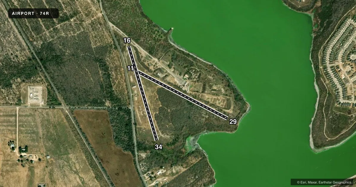
Airport sketch
Runways drawn to scale from FAA survey coordinates, rendered over satellite imagery. Not for navigation.
Approaches & charts
Services on the field
Fuel grades, oxygen, maintenance, ramp storage and lighting — as declared to the FAA by the airport operator.
Fuel & services
- Fuel
- Not available
- Oxygen (bottled)
- Not available
- Oxygen (bulk)
- Not available
Ramp & ground
- Transient storage
- Tie-down
- Hangar
- Landing fee
- No fee published
- Customs
- Not available
- Wind indicator
- Yes
- Segmented circle
- No
Fuel & FBOs
Cheapest 100LL and Jet A on the field and nearby. Always confirm with the FBO before taxi.
Airport notes
Surface conditions, obstructions, local procedures, lighting outages and other notes published with each FAA cycle.
General notes
- NO LINE OF SIGHT BETWEEN RWYS 34 & 29
- WILD HOGS ON OR INVOF ARPT.
- FOR CD CTC SAN ANTONIO APCH AT 210-805-5516.
- ARPT PHYS ADS: 13680 PLEASANTON RD, SAN ANTONIO, TX.
- ACTIVE SHOOTING RANGE ADJACENT.
- NO BUILDINGS. NO FACILITIES. NO SERVICES.
Other notes
- PREDATES ACT.
- 11/29RWY ROUGH & UNEVEN, NOT MNTND. NOT SUITABLE FOR ACFT.
- 16/34RWY ROUGH & UNEVEN, NOT MNTND. NOT SUITABLE FOR ACFT.
VFR map & nearby airports
VFR sectional. Tap any ICAO chip to open that airport.
Key facts · 74R
Answer card- ICAO
- 74R
- Name
- HORIZON
- Location
- SAN ANTONIO, TEXAS
- Elevation
- 551 ft MSL
- Traffic pattern altitude
- 1,551 ft MSL (1,000 AGL)
- Control tower
- Non-towered (use CTAF)
- Total runways
- 2
- Longest runway
- 11/29 · 2,360 ft
- Published ILS approaches
- 0
- Published frequencies
- 1
- Magnetic variation
- 7°
- Current flight rules
- MVFR
- Current wind
- 130° at 4 kt
- Favored runway now
- RWY 11
HORIZON (74R) sits in San Antonio, Texas at 551 ft MSL. It has two turf runways. The longest is 11/29 at 2,360 ft. The field is non-towered. CTAF is 122.9. No ILS approaches are published here.
The pattern altitude is not published. Use the standard 1,000 ft AGL pattern for light piston operations unless the current Chart Supplement says otherwise. The airport is in the San Antonio area, so keep a close eye on local traffic flow and get current field information before you go. For clearance delivery, contact San Antonio Approach at 210-805-5516.
Runway 11/29 is rough and uneven. It is not regularly maintained. The published remarks also say there is no line of sight between runways 34 and 29. Wild hogs are reported on or near the airport, so a careful taxi and landing scan makes sense. There are no on-field FBOs listed. If you need fuel or other services, contact the airport operator directly or call the field before arrival. The airport physical address is 13680 Pleasanton Road, San Antonio, Texas.