METAR & TAF KPEZ
Current METAR
Observed 13:15Z
KPEZ 271315Z AUTO 15004KT 10SM BKN009 24/22 A2999 RMK AO2 T02420223
- Wind
- 150° @ 4 kt
- Visibility
- 10 SM
- Temp / Dew
- 24°C / 22°C
- Altimeter
- 29.99 inHg
- Clouds
- BKN
- Density alt
- 1,527 ft
- Ceiling
- 900 ft AGL
- Rules
- IFR
Airport info & contacts
Manager on record, flight service, ARTCC, attendance schedule and pattern altitude — published by the FAA and refreshed every 28 days.
Location
- From city
- 3 NM W
- VFR sectional
- SAN ANTONIO
- ARTCC
- ZHU · HOUSTON
- NOTAM facility
- SJT (NOTAM-D)
Airport manager
- Name
- JOHN ROBERTS
- Phone
- 830-569-3155
- Address
- PO BOX 209, PLEASANTON TX 78064
Flight service · Hours
- FSS SJT
- SAN ANGELO1-800-WX-BRIEF
- Attendance
- MON-FRI · 0800-1700
Frequencies
Tap any row to copy the frequency to your clipboard.
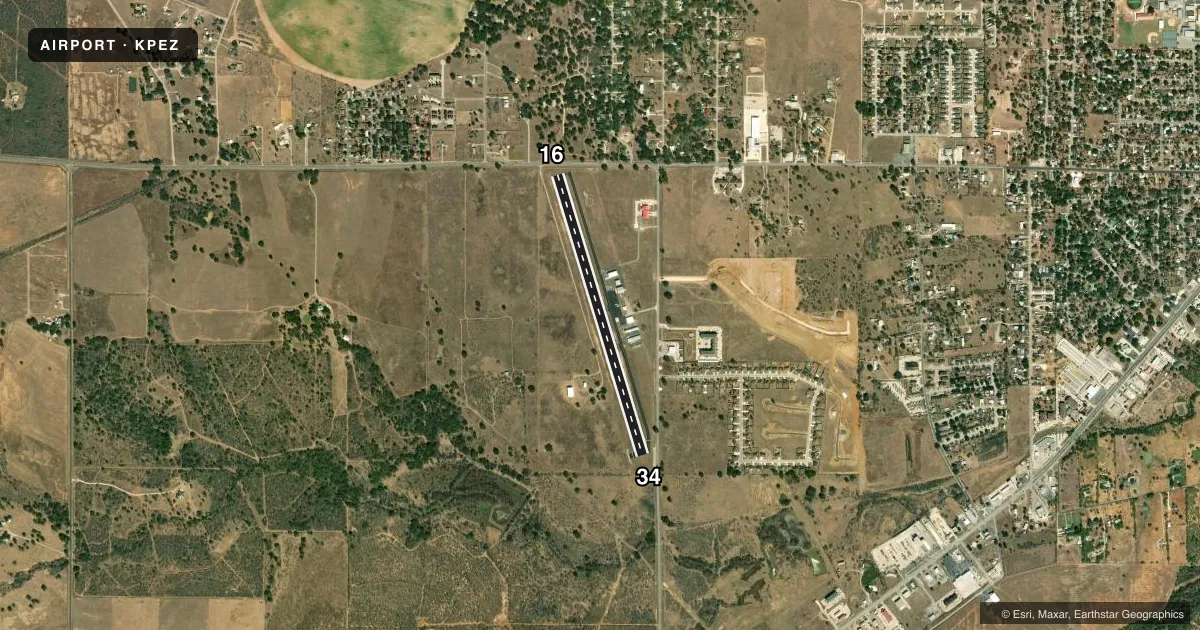
Runways & pattern
Full pagePattern entry · RWY 16
LEFT TRAFFICRunway end performance
| End | TORA | TODA | ASDA | LDA | VGSI | Approach lights | Obstruction |
|---|---|---|---|---|---|---|---|
| 16 | — | — | — | — | PAPI 2-box left(4°) | — | 16', road, 201' from thr, 250' R of cntrln, slope 0 |
| 34 | — | — | — | — | PAPI 2-box left(3°) | — | 8', fence, 201' from thr, 90' R of cntrln, slope 0 |
Declared distances in feet. TORA = takeoff run available, TODA = takeoff distance, ASDA = accelerate-stop, LDA = landing distance.
Airport sketch
Runways drawn to scale from FAA survey coordinates, rendered over satellite imagery. Not for navigation.
Approaches & charts
Services on the field
Fuel grades, oxygen, maintenance, ramp storage and lighting — as declared to the FAA by the airport operator.
Fuel & services
- Fuel
- 100LLAA+
- Oxygen (bottled)
- Not available
- Oxygen (bulk)
- Not available
Ramp & ground
- Transient storage
- Tie-down
- Hangar
- Landing fee
- No fee published
- Customs
- Not available
- Lighting schedule
- SEE RMK
- Beacon schedule
- SS-SR
- Beacon
- White / Green (civil land)(WG)
- Wind indicator
- Lighted
- Segmented circle
- Yes
Fuel & FBOs
Cheapest 100LL and Jet A on the field and nearby. Always confirm with the FBO before taxi.
Airport notes
Surface conditions, obstructions, local procedures, lighting outages and other notes published with each FAA cycle.
General notes
- FOR CD IF UNA TO CTC VIA FREQ, CTC SAN ANTONIO APCH AT 210-805-5516.
Lighting notes
- DUSK-DAWN. MIRL RWY 16/34 PRESET LOW INTST; TO INCR INTST ACTVT - CTAF.
Fuel notes
- 100LL100 LL AND JET A SELF SERVE. JET A AVBL FULL SERVE DURING ATTND HRS AND ON CALL AFTER HRS.
Approach & departure obstructions
- 168 FT FENCE, 36 FT DSTC, 220 FT L.
- 348 FT FENCE, 0-199 FT DSTC, R/L.
- 16APCH SLOPE 0:1 AT DSPLCD THR OVR 8 FT FENCE AT DSPLCD THR 190 FT RIGHT.
Other notes
- 1FOR SVCS CALL 830-569-3155.
- MANAGERASST UTILITIES SUPT.
- MANAGEREXT 800
VFR map & nearby airports
VFR sectional. Tap any ICAO chip to open that airport.
Key facts · KPEZ
Answer card- ICAO
- KPEZ
- Name
- PLEASANTON MUNI
- Location
- PLEASANTON, TEXAS
- Elevation
- 430.4 ft MSL
- Traffic pattern altitude
- 1,430.4 ft MSL (1,000 AGL)
- Control tower
- Non-towered (use CTAF)
- Total runways
- 1
- Longest runway
- 16/34 · 4,000 ft
- Published ILS approaches
- 0
- Published frequencies
- 7
- Magnetic variation
- 6°
- Current flight rules
- IFR
- Current wind
- 150° at 4 kt
- Favored runway now
- RWY 16
Pleasanton Muni is in Pleasanton, Texas. The field elevation is 430.4 ft MSL. It has one runway, 16/34, which is 4,000 ft long. There is no control tower. The pattern altitude is not published, so use the standard 1,000 ft AGL for light piston traffic unless the current Chart Supplement says otherwise.
No ILS approaches are published here. The field uses CTAF 122.7 and UNICOM 122.7. San Antonio Approach handles the surrounding airspace, so have the current frequencies ready before you go. The on-field FBO is Pleasanton Municipal Airport. It carries 100LL and Jet A. Self-serve 100LL and Jet A are available. Jet A is full serve during attended hours and on call after hours.
A few published remarks matter for the first visit. Runway lights are on from dusk to dawn. The medium intensity lights on 16/34 start at low intensity. You can increase them by keying the CTAF. There is an 8-foot fence near runway 16, with another fence line close to runway 34. For clearance delivery if you cannot raise the field by radio, call San Antonio Approach. Expect a small, uncontrolled field with local lighting and obstacle awareness on final.