METAR & TAF T30
T30 does not publish a METAR.
Showing the nearest reporting station: KCOT (COTULLA-LA SALLE COUNTY) · 22.7 NM away. Conditions at T30 may differ.
METAR · KCOT
Observed 11:53Z
KCOT 271153Z AUTO 13007KT 10SM CLR 24/22 A2994 RMK AO2 SLP129 T02440217 10283 20244 55001
- Wind
- 130° @ 7 kt
- Visibility
- 10 SM
- Temp / Dew
- 24°C / 22°C
- Altimeter
- 29.94 inHg
- Clouds
- CLR
- Density alt
- 1,782 ft
- Ceiling
- Unlimited
- Rules
- VFR
Airport info & contacts
Manager on record, flight service, ARTCC, attendance schedule and pattern altitude — published by the FAA and refreshed every 28 days.
Location
- From city
- 4 NM S
- VFR sectional
- SAN ANTONIO
- ARTCC
- ZHU · HOUSTON
- NOTAM facility
- SJT (NOTAM-D)
Airport manager
- Name
- IKE & NATHAN MC KINLEY
- Phone
- 830-334-7306
- Address
- 170 ENCINO, PEARSALL TX 78061
Flight service · Hours
- FSS SJT
- SAN ANGELO1-800-WX-BRIEF
- Attendance
- ALL
Frequencies
Tap any row to copy the frequency to your clipboard.
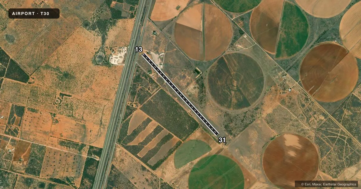
Runways & pattern
Full pagePattern entry · RWY 13
LEFT TRAFFICRunway end performance
| End | TORA | TODA | ASDA | LDA | VGSI | Approach lights | Obstruction |
|---|---|---|---|---|---|---|---|
| 13 | — | — | — | — | — | — | 15', road, 201' from thr, 76' R of cntrln, slope 0 |
| 31 | — | — | — | — | — | — | 60', pline, 2120' from thr, 0' R of cntrln, slope 32 |
Declared distances in feet. TORA = takeoff run available, TODA = takeoff distance, ASDA = accelerate-stop, LDA = landing distance.
Airport sketch
Runways drawn to scale from FAA survey coordinates, rendered over satellite imagery. Not for navigation.
Approaches & charts
Services on the field
Fuel grades, oxygen, maintenance, ramp storage and lighting — as declared to the FAA by the airport operator.
Fuel & services
- Fuel
- A
- Oxygen (bottled)
- Not available
- Oxygen (bulk)
- Not available
- Airframe repair
- Not available
- Power plant repair
- Not available
- Other services
- AGRI
Ramp & ground
- Transient storage
- Tie-down
- Landing fee
- Yes
- Customs
- Not available
- Lighting schedule
- SS-SR
- Wind indicator
- Lighted
- Segmented circle
- Yes
Fuel & FBOs
Cheapest 100LL and Jet A on the field and nearby. Always confirm with the FBO before taxi.
Airport notes
Surface conditions, obstructions, local procedures, lighting outages and other notes published with each FAA cycle.
General notes
- FOR CD CTC HOUSTON ARTCC AT 281-230-5622.
- DSPLCD THRS NOT LGTD, 4705 FT AVBL NGT.
Runway surface & condition
- 13/31ESTD.
- 13/31NSTD LIRL; SPACING 20 FT FM EDGE & 300 FT BTN LGTS.
Approach & departure obstructions
- 13MKGS FADED.
- 31MKGS FADED.
- 13APCH RATIO 22:1 TO DSPLCD THR; 15 FT ROAD 330 FT FM DSPLCD THR 130 FT RIGHT.
- 31APCH RATIO 37:1 TO DSPLCD THR.
Other notes
- THIS AIRPORT HAS BEEN SURVEYED BY THE NATIONAL GEODETIC SURVEY.
- MANAGERALT MGR NUMBER NATHAN MC KINLEY 210-542-0093
VFR map & nearby airports
VFR sectional. Tap any ICAO chip to open that airport.
Key facts · T30
Answer card- ICAO
- T30
- Name
- MC KINLEY FLD
- Location
- PEARSALL, TEXAS
- Elevation
- 586.4 ft MSL
- Traffic pattern altitude
- 1,586.4 ft MSL (1,000 AGL)
- Control tower
- Non-towered (use CTAF)
- Total runways
- 1
- Longest runway
- 13/31 · 5,027 ft
- Published ILS approaches
- 0
- Published frequencies
- 2
- Magnetic variation
- 7°
- Current flight rules
- VFR
- Current wind
- 130° at 7 kt
- Favored runway now
- RWY 13
MC KINLEY FLD (T30) sits in Pearsall, Texas at 586.4 ft MSL. It has one runway. Runway 13/31 is 5,027 ft of asphalt, which is the longest runway on the field. There is no control tower. CTAF and UNICOM are both 122.8. No ILS approaches are published.
The published pattern altitude is not listed, so use the standard 1,000 ft AGL for light piston operations unless the current Chart Supplement says otherwise. The field has one on-field FBO, McKinley Aerial Service. It carries JET_A_PRIST. If you need anything beyond that, call the FBO directly before departure.
A few published remarks matter here. Runway 13 and runway 31 both have faded markings. Runway 13 has nonstandard low intensity lighting with lights set close to the edge and spaced widely. Runway 31 has a displaced-threshold approach note with a road near the approach path. Gross weight is established on 13/31. Clearance delivery is handled through Houston ARTCC. For a first-time arrival, treat this as a non-towered field with published runway and approach caveats. Check the current Chart Supplement before you go, especially if you are planning a night arrival or a heavier aircraft.