METAR & TAF 67R
67R does not publish a METAR.
Showing the nearest reporting station: KMFE (MC ALLEN INTL) · 35.9 NM away. Conditions at 67R may differ.
METAR · KMFE
Observed 12:53Z
KMFE 271253Z 14008KT 10SM CLR 27/24 A2995 RMK AO2 SLP141 T02720244
- Wind
- 140° @ 8 kt
- Visibility
- 10 SM
- Temp / Dew
- 27°C / 24°C
- Altimeter
- 29.95 inHg
- Clouds
- CLR
- Density alt
- 1,763 ft
- Ceiling
- Unlimited
- Rules
- VFR
Airport info & contacts
Manager on record, flight service, ARTCC, attendance schedule and pattern altitude — published by the FAA and refreshed every 28 days.
Location
- From city
- 3 NM NW
- VFR sectional
- BROWNSVILLE
- ARTCC
- ZHU · HOUSTON
- NOTAM facility
- SJT (NOTAM-D)
Airport manager
- Name
- MANUEL M. MUNIZ
- Phone
- 956-487-5312
- Address
- 5332 E. US-83, RIO GRANDE CITY TX 78582
Flight service · Hours
- FSS SJT
- SAN ANGELO1-800-WX-BRIEF
- Attendance
- Unattended
Frequencies
Tap any row to copy the frequency to your clipboard.
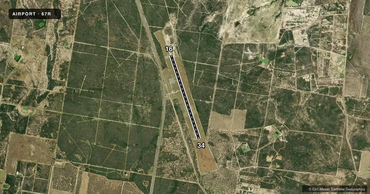
Runways & pattern
Full pagePattern entry · RWY 16
LEFT TRAFFICAirport sketch
Runways drawn to scale from FAA survey coordinates, rendered over satellite imagery. Not for navigation.
Approaches & charts
Services on the field
Fuel grades, oxygen, maintenance, ramp storage and lighting — as declared to the FAA by the airport operator.
Fuel & services
- Fuel
- Not available
Ramp & ground
- Transient storage
- Tie-down
- Landing fee
- No fee published
- Lighting schedule
- SEE RMK
- Beacon schedule
- SS-SR
- Beacon
- White / Green (civil land)(WG)
- Wind indicator
- Lighted
- Segmented circle
- Yes
Fuel & FBOs
Cheapest 100LL and Jet A on the field and nearby. Always confirm with the FBO before taxi.
Airport notes
Surface conditions, obstructions, local procedures, lighting outages and other notes published with each FAA cycle.
General notes
- ARPT GATE CLSD AND LOCKED CALL 956-487-5312 FOR ACCESS. NO PUBLIC PHONE AVBL. TERMINAL BLDG LOCKED.
- FOR CD CTC HOUSTON ARTCC AT 281-230-5622.
Lighting notes
- MIRL RWY 16/34 PRESET LOW INTST; TO INCR INTST ACTVT - CTAF.
Other notes
- THIS AIRPORT HAS BEEN SURVEYED BY THE NATIONAL GEODETIC SURVEY.
- MANAGERFIRE CHIEF/ARPT MGR.
VFR map & nearby airports
VFR sectional. Tap any ICAO chip to open that airport.
Key facts · 67R
Answer card- ICAO
- 67R
- Name
- RIO GRANDE CITY MUNI
- Location
- RIO GRANDE CITY, TEXAS
- Elevation
- 290.3 ft MSL
- Traffic pattern altitude
- 1,290.3 ft MSL (1,000 AGL)
- Control tower
- Non-towered (use CTAF)
- Total runways
- 1
- Longest runway
- 16/34 · 4,000 ft
- Published ILS approaches
- 0
- Published frequencies
- 1
- Magnetic variation
- 7°
- Current flight rules
- VFR
- Current wind
- 140° at 8 kt
- Favored runway now
- RWY 16
Rio Grande City Muni sits in Rio Grande City, Texas. Field elevation is 290.3 ft MSL. The airport has one runway. Runway 16/34 is 4,000 ft of asphalt. There is no control tower. CTAF is 122.9.
No ILS approaches are published here. Pattern altitude is not published in the facts, so use the current Chart Supplement before you fly. The runway lights on 16/34 are medium intensity. They come up on the CTAF. The airport gate is closed and locked. Call 956-487-5312 for access. The terminal building is locked too.
There are no on-field FBOs listed in the facts. Contact the airport operator directly before arrival, or call the field on CTAF for current FBO availability. For clearance delivery, Houston ARTCC can be reached at 281-230-5622. First-time pilots should plan for an unattended field with limited on-airport access. Check current airport notes before departure so you are not surprised by gate access or lighting setup.