METAR & TAF KEBG
Current METAR
Observed 13:15Z
KEBG 271315Z AUTO 16005KT 1 1/4SM HZ CLR 27/24 A2994 RMK AO2 VIS 3/4V5
- Wind
- 160° @ 5 kt
- Visibility
- 0.25 SM
- Temp / Dew
- 27°C / 24°C
- Altimeter
- 29.94 inHg
- Clouds
- CLR
- Density alt
- 1,508 ft
- Ceiling
- Unlimited
- Rules
- LIFR
Airport info & contacts
Manager on record, flight service, ARTCC, attendance schedule and pattern altitude — published by the FAA and refreshed every 28 days.
Location
- From city
- 9 NM N
- VFR sectional
- BROWNSVILLE
- ARTCC
- ZHU · HOUSTON
- NOTAM facility
- EBG (NOTAM-D)
Airport manager
- Name
- EDDIE VELARDE
- Phone
- 956-292-2047
- Address
- 1300 E. FM 490, EDINBURG TX 78542
Flight service · Hours
- FSS SJT
- SAN ANGELO1-800-WX-BRIEF
- Attendance
- 0800-1700++
Frequencies
Tap any row to copy the frequency to your clipboard.
Runways & pattern
Full pagePattern entry · RWY 14
LEFT TRAFFICRunway end performance
| End | TORA | TODA | ASDA | LDA | VGSI | Approach lights | Obstruction |
|---|---|---|---|---|---|---|---|
| 14 | — | — | — | — | PAPI 2-box left(3°) | — | — |
| 32 | — | — | — | — | PAPI 2-box left(3°) | — | — |
Declared distances in feet. TORA = takeoff run available, TODA = takeoff distance, ASDA = accelerate-stop, LDA = landing distance.
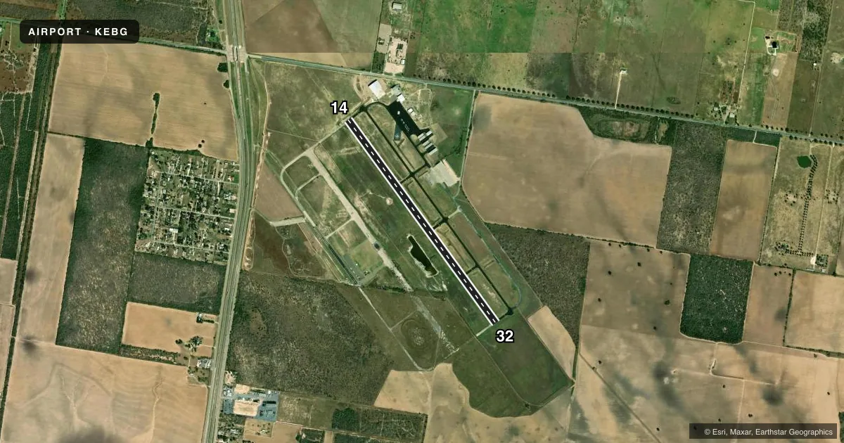
Airport sketch
Runways drawn to scale from FAA survey coordinates, rendered over satellite imagery. Not for navigation.
Approaches & charts
Services on the field
Fuel grades, oxygen, maintenance, ramp storage and lighting — as declared to the FAA by the airport operator.
Fuel & services
- Fuel
- 100LLA+
- Other services
- INSTR
Ramp & ground
- Transient storage
- Tie-down
- Landing fee
- No fee published
- Customs
- Not available
- Lighting schedule
- SEE RMK
- Beacon schedule
- SS-SR
- Beacon
- White / Green (civil land)(WG)
- Wind indicator
- Lighted
- Segmented circle
- Yes
Fuel & FBOs
Cheapest 100LL and Jet A on the field and nearby. Always confirm with the FBO before taxi.
Airport notes
Surface conditions, obstructions, local procedures, lighting outages and other notes published with each FAA cycle.
General notes
- 100 FT POLE 595 FT NE OF HELIPAD.
- TWY HAS REFLECTORS ON PAVEMENT.
- FOR CD CTC CORPUS CHRISTI APCH AT 361-299-4230.
- CUST AVBL M-F 0800-1600++.
Lighting notes
- MIRL RWY 14/32 PRESET LOW INTST; TO INCR INTST AND ACTVT REIL RWY 14 - CTAF.
Fuel notes
- 100LL100LL & JET A+ 24 HR SELF SVC, FULL SERVE DURG ATNDD HRS..
Other notes
- THIS AIRPORT HAS BEEN SURVEYED BY THE NATIONAL GEODETIC SURVEY.
- PRE DATES THE ACT.
VFR map & nearby airports
VFR sectional. Tap any ICAO chip to open that airport.
Key facts · KEBG
Answer card- ICAO
- KEBG
- Name
- SOUTH TEXAS INTL AT EDINBURG
- Location
- EDINBURG, TEXAS
- Elevation
- 75.2 ft MSL
- Traffic pattern altitude
- 1,075.2 ft MSL (1,000 AGL)
- Control tower
- Non-towered (use CTAF)
- Total runways
- 1
- Longest runway
- 14/32 · 5,000 ft
- Published ILS approaches
- 0
- Published frequencies
- 4
- Magnetic variation
- 6°
- Current flight rules
- LIFR
- Current wind
- 160° at 5 kt
- Favored runway now
- RWY 14
South Texas Intl at Edinburg sits in Edinburg, Texas at 75.2 ft MSL. The field has one runway. Runway 14/32 is asphalt and measures 5,000 ft. There is no control tower. The published traffic pattern altitude is not listed, so use the standard 1,000 ft AGL for light piston traffic unless the current Chart Supplement says otherwise.
No ILS approaches are published here. The field uses CTAF and UNICOM on 122.8. For approach or departure coordination, the published frequency is VALLEY on 126.55 or 377.2. The on-field FBO is South Texas International Airport. It carries 100LL and Jet A Prist. Published remarks say both fuels are available 24 hours self-serve with full service during attended hours.
A few operational items matter here. Runway 14/32 has medium intensity lights preset to low. Use CTAF to increase intensity and to activate the runway end identifier lights on runway 14. Precision approach path indicators on both runway ends operate continuously. Wildlife activity occurs daily from sunset to sunrise, so a night arrival deserves extra attention. The airport also notes a taxiway with pavement reflectors. If you need hangar space, call ahead. This is a non-towered field, so expect self-announce traffic and verify any current local procedures with the airport operator or the current FAA Chart Supplement.