METAR & TAF T05
T05 does not publish a METAR.
Showing the nearest reporting station: KHRL (VALLEY INTL) · 23.2 NM away. Conditions at T05 may differ.
METAR · KHRL
Observed 12:52Z
KHRL 271252Z 15007KT 10SM CLR 26/25 A2995 RMK AO2 SLP140 T02560250
- Wind
- 150° @ 7 kt
- Visibility
- 10 SM
- Temp / Dew
- 26°C / 25°C
- Altimeter
- 29.95 inHg
- Clouds
- CLR
- Density alt
- 1,295 ft
- Ceiling
- Unlimited
- Rules
- VFR
Airport info & contacts
Manager on record, flight service, ARTCC, attendance schedule and pattern altitude — published by the FAA and refreshed every 28 days.
Location
- From city
- 1 NM NW
- VFR sectional
- BROWNSVILLE
- ARTCC
- ZHU · HOUSTON
- NOTAM facility
- SJT (NOTAM-D)
Airport manager
- Name
- FRANK VASQUEZ
- Phone
- 956-944-2325
- Address
- 818 MANSFIELD DR. UNIT 78, PORT MANSFIELD TX 78598
Flight service · Hours
- FSS SJT
- SAN ANGELO1-800-WX-BRIEF
- Attendance
- Unattended
Frequencies
Tap any row to copy the frequency to your clipboard.
Runways & pattern
Full pagePattern entry · RWY 12
LEFT TRAFFICRunway end performance
| End | TORA | TODA | ASDA | LDA | VGSI | Approach lights | Obstruction |
|---|---|---|---|---|---|---|---|
| 12 | — | — | — | — | — | — | 30', pline, 1460' from thr, 0' R of cntrln, slope 42 |
| 30 | — | — | — | — | — | — | 30', pline, 1250' from thr, 0' R of cntrln, slope 34 |
Declared distances in feet. TORA = takeoff run available, TODA = takeoff distance, ASDA = accelerate-stop, LDA = landing distance.
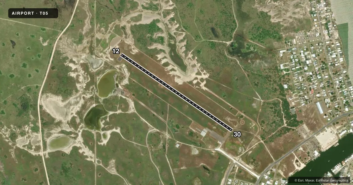
Airport sketch
Runways drawn to scale from FAA survey coordinates, rendered over satellite imagery. Not for navigation.
Approaches & charts
Services on the field
Fuel grades, oxygen, maintenance, ramp storage and lighting — as declared to the FAA by the airport operator.
Fuel & services
- Fuel
- Not available
- Oxygen (bottled)
- Not available
- Oxygen (bulk)
- Not available
- Airframe repair
- Not available
- Power plant repair
- Not available
Ramp & ground
- Transient storage
- Tie-down
- Customs
- Not available
- Lighting schedule
- SEE RMK
- Beacon schedule
- SS-SR
- Beacon
- White / Green (civil land)(WG)
- Wind indicator
- Lighted
- Segmented circle
- Yes
Fuel & FBOs
Cheapest 100LL and Jet A on the field and nearby. Always confirm with the FBO before taxi.
Airport notes
Surface conditions, obstructions, local procedures, lighting outages and other notes published with each FAA cycle.
General notes
- DEER & BIRDS ON & INVOF ARPT.
- FOR CD CTC CORPUS CHRISTI APCH AT 361-299-4230.
- NO PUBLIC FACILITIES, NO RESTROOMS.
Lighting notes
- SS-SR MIRL RWY 12/30 PRESET LOW INTST; TO INCR INTST - CTAF.
Approach & departure obstructions
- 12RWY 12 & 30 MKGS DISCOLORED.
Other notes
- FEE FOR OVNGT TIE DOWN.
- 1HARBOR SUPERINTENDENT'S OFC ATNDD 0800-1650.
VFR map & nearby airports
VFR sectional. Tap any ICAO chip to open that airport.
Key facts · T05
Answer card- ICAO
- T05
- Name
- CHARLES R JOHNSON
- Location
- PORT MANSFIELD, TEXAS
- Elevation
- 10 ft MSL
- Traffic pattern altitude
- 1,010 ft MSL (1,000 AGL)
- Control tower
- Non-towered (use CTAF)
- Total runways
- 1
- Longest runway
- 12/30 · 3,200 ft
- Published ILS approaches
- 0
- Published frequencies
- 1
- Magnetic variation
- 7°
- Current flight rules
- VFR
- Current wind
- 150° at 7 kt
- Favored runway now
- RWY 12
Charles R Johnson Airport sits in Port Mansfield, Texas. Field elevation is 10 ft MSL. The airport has one runway. Runway 12/30 is 3,200 ft of asphalt, so it is the runway to plan around here. There is no control tower. CTAF is 122.9.
No ILS approaches are published. Pattern altitude is not published in the facts, so use the current FAA Chart Supplement before you go. The airport has medium intensity runway lights on 12/30. They start at low intensity. Activate the CTAF to bring the lights up. Runway markings on both ends are reported as discolored, so expect a tired visual picture on rollout and lineup.
The on-field FBO is Charles R. Johnson Airport. Fuel grades are not reported in the facts. Call the FBO directly at (956) 944-2325 for current fuel availability. Published remarks also note a fee for overnight tie down. Deer and birds are reported on and near the airport, so keep a sharp scan on taxi, takeoff and landing. For clearance delivery, contact Corpus Christi Approach at 361-299-4230. The harbor superintendent's office is attended from 0800 to 1650. That is useful if you need local coordination before arrival.