METAR & TAF KHRL
Current METAR
Observed 18:52Z
KHRL 271852Z 16012G24KT 10SM CLR 37/20 A2992 RMK AO2 SLP130 T03720200
- Wind
- 160° @ 12G24 kt
- Visibility
- 10 SM
- Temp / Dew
- 37°C / 20°C
- Altimeter
- 29.92 inHg
- Clouds
- CLR
- Density alt
- 2,685 ft
- Ceiling
- Unlimited
- Rules
- VFR
Airport info & contacts
Manager on record, flight service, ARTCC, attendance schedule and pattern altitude — published by the FAA and refreshed every 28 days.
Location
- From city
- 3 NM NE
- VFR sectional
- BROWNSVILLE
- ARTCC
- ZHU · HOUSTON
- NOTAM facility
- HRL (NOTAM-D)
Airport manager
- Name
- PAUL WIDISH
- Phone
- 956-430-8605
- Address
- HARLINGEN INTL AIRPORT, 3200 HERITAGE WAY, HARLINGEN TX 78550
Flight service · Hours
- FSS SJT
- SAN ANGELO1-800-WX-BRIEF
- Attendance
- 0600-0000
Frequencies
Tap any row to copy the frequency to your clipboard.
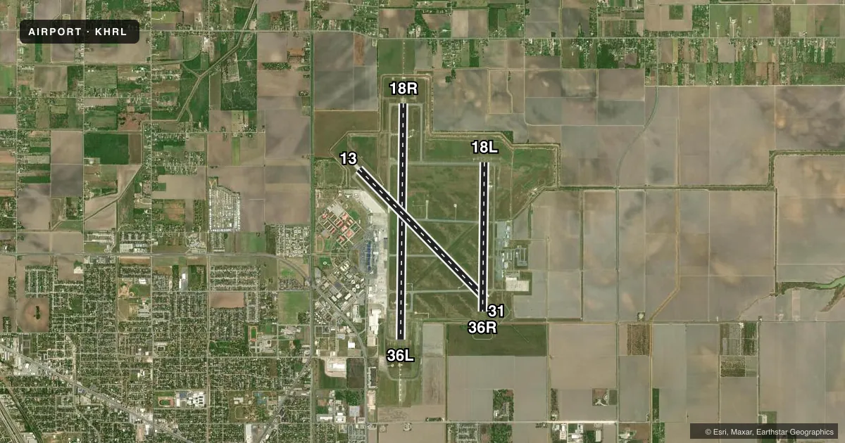
Runways & pattern
Full pagePattern entry · RWY 18R
RIGHT TRAFFIC| Runway | Heading (°M) | Length | Surface | Traffic |
|---|---|---|---|---|
| 18R/36LFavored | 178° / 358° | 9,400 ft | ASPH | 18R R |
| 13/31 | 133° / 313° | 7,257 ft | ASPH | Standard L |
| 18L/36R | 178° / 358° | 5,950 ft | ASPH | 36R R |
Runway end performance
| End | TORA | TODA | ASDA | LDA | VGSI | Approach lights | Obstruction |
|---|---|---|---|---|---|---|---|
| 18R | 9,400' | 9,400' | 9,400' | 9,400' | PAPI 4-box left(3°) | MALSR | — |
| 36L | 9,400' | 9,400' | 9,400' | 9,400' | PAPI 4-box right(3°) | MALSR | — |
| 13 | 7,257' | 7,257' | 7,257' | 7,257' | PAPI 4-box left(3°) | — | — |
| 31 | 7,257' | 7,257' | 7,257' | 7,257' | PAPI 4-box left(3°) | MALSR | — |
| 18L | 5,949' | 5,949' | 5,949' | 5,949' | PAPI 4-box left(3°) | — | — |
| 36R | 5,949' | 5,949' | 5,949' | 5,759' | — | — | — |
Declared distances in feet. TORA = takeoff run available, TODA = takeoff distance, ASDA = accelerate-stop, LDA = landing distance.
Airport sketch
Runways drawn to scale from FAA survey coordinates, rendered over satellite imagery. Not for navigation.
Approaches & charts
ILS · 2
Services on the field
Fuel grades, oxygen, maintenance, ramp storage and lighting — as declared to the FAA by the airport operator.
Fuel & services
- Fuel
- 100LLA
- Oxygen (bottled)
- High pressure
- Airframe repair
- Major
- Power plant repair
- Major
- Other services
- AFRT,AVNCS,CARGO,CHTR,INSTR,RNTL,SALES
Ramp & ground
- Transient storage
- Tie-down
- Hangar
- Landing fee
- No fee published
- Customs
- Not available
- Lighting schedule
- SEE RMK
- Beacon schedule
- SS-SR
- Beacon
- White / Green (civil land)(WG)
- Wind indicator
- Lighted
- Segmented circle
- Yes
Fuel & FBOs
Cheapest 100LL and Jet A on the field and nearby. Always confirm with the FBO before taxi.
Airport notes
Surface conditions, obstructions, local procedures, lighting outages and other notes published with each FAA cycle.
General notes
- MIGRATORY BIRDS ON & INVOF ARPT.
- WHEN ATCT CLSD REQ ARFF THRU CORPUS APPROACH OR FLT SVC.
- FOR CD WHEN ATCT IS CLSD CTC CRP APCH AT 361-299-4230.
Lighting notes
- DUSK-DAWN. WHEN ATCT CLSD ACTVT MALSR RWY 18R, RWY 31, RWY 36L - CTAF.
Runway surface & condition
- 13/31PCR VALUE: 310/F/D/X/T
- 18L/36RPCR VALUE: 210/R/B/W/T
- 18R/36LPCR VALUE: 380/F/D/X/T
Approach & departure obstructions
- 18LUNUSBL BYD 7 DEGS RIGHT OF CNTRLN.
Other notes
- ARFF INDEX C AVAILABLE. PPR FOR ACR ACFT GREATER THAN 126 FEET IN LENGTH CALL 956-430-8605.
VFR map & nearby airports
VFR sectional. Tap any ICAO chip to open that airport.
Key facts · KHRL
Answer card- ICAO
- KHRL
- Name
- VALLEY INTL
- Location
- HARLINGEN, TEXAS
- Elevation
- 36.3 ft MSL
- Traffic pattern altitude
- 1,036.3 ft MSL (1,000 AGL)
- Control tower
- Towered · 0600-0000
- Total runways
- 3
- Longest runway
- 18R/36L · 9,400 ft
- Published ILS approaches
- 2
- Published frequencies
- 10
- Magnetic variation
- 3°
- Current flight rules
- VFR
- Current wind
- 160° at 12 kt
- Favored runway now
- RWY 18R
Valley Intl sits in Harlingen, Texas. The field elevation is 36.3 ft MSL. It has three asphalt runways. The longest is 9,400 ft on 18R/36L. The airport is towered from 0600 to 0000. Two ILS approaches are published. They serve runway ends 18R and 36L.
Pattern altitude is not published. Use 1,000 ft AGL for light piston traffic unless ATC or the current Chart Supplement says otherwise. The field sits in Class C airspace. Expect busy radio work around the towered hours. Migratory birds are reported on and near the airport. Keep a sharp scan on departure and arrival. Lighting is available from dusk to dawn. When the tower is closed, the MALSR can be activated on 18R, 31 and 36L by using CTAF.
Sun Valley Aviation is on the field. Gulf Aviation is on the field too. Both carry 100LL and Jet A. For clearance delivery when the tower is closed, contact Corpus Approach. Runway 18L is unusable beyond 7 degrees right of centerline. Aircraft over 126 ft need prior permission. Check with the airport operator before arrival if your operation is near that limit.