METAR & TAF KPIL
Current METAR
Observed 16:53Z
KPIL 271653Z AUTO 16012G22KT 10SM CLR 34/23 A2997 RMK AO2 SLP149 T03390228 $
- Wind
- 160° @ 12G22 kt
- Visibility
- 10 SM
- Temp / Dew
- 34°C / 23°C
- Altimeter
- 29.97 inHg
- Clouds
- CLR
- Density alt
- 2,241 ft
- Ceiling
- Unlimited
- Rules
- VFR
Airport info & contacts
Manager on record, flight service, ARTCC, attendance schedule and pattern altitude — published by the FAA and refreshed every 28 days.
Location
- From city
- 10 NM NW
- VFR sectional
- BROWNSVILLE
- ARTCC
- ZHU · HOUSTON
- NOTAM facility
- PIL (NOTAM-D)
Airport manager
- Name
- JOE VEGA
- Phone
- 956-761-3700
- Address
- 33174 STATE PARK RD 100 SOUTH, SOUTH PADRE ISLAND TX 78597
Flight service · Hours
- FSS SJT
- SAN ANGELO1-800-WX-BRIEF
- Attendance
- 0800-1700
Frequencies
Tap any row to copy the frequency to your clipboard.
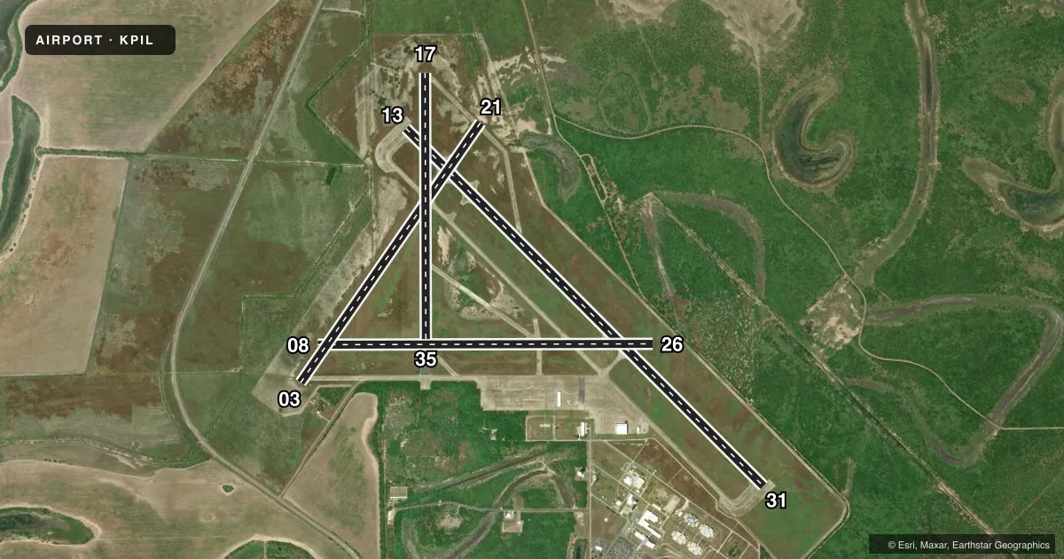
Runways & pattern
Full pagePattern entry · RWY 17
LEFT TRAFFIC| Runway | Heading (°M) | Length | Surface | Traffic |
|---|---|---|---|---|
| 13/31 | 130° / 310° | 8,001 ft | ASPH-CONC | Standard L |
| 08/26 | 85° / 265° | 5,317 ft | CONC | Standard L |
| 03/21 | 30° / 210° | 5,000 ft | ASPH-CONC | Standard L |
| 17/35Favored | 175° / 355° | 4,200 ft | ASPH-CONC | Standard L |
Runway end performance
| End | TORA | TODA | ASDA | LDA | VGSI | Approach lights | Obstruction |
|---|---|---|---|---|---|---|---|
| 13 | — | — | — | — | PAPI 2-box left(2°) | — | — |
| 31 | — | — | — | — | PAPI 2-box left(3°) | — | — |
| 08 | — | — | — | — | — | — | 8', fence, 330' from thr, 261' R of cntrln, slope 16 |
| 26 | — | — | — | — | — | — | 25', trees, 268' from thr, 250' R of cntrln, slope 2 |
| 35 | — | — | — | — | — | — | 273', tower, 4000' from thr, 605' R of cntrln, slope 13 |
Declared distances in feet. TORA = takeoff run available, TODA = takeoff distance, ASDA = accelerate-stop, LDA = landing distance.
Airport sketch
Runways drawn to scale from FAA survey coordinates, rendered over satellite imagery. Not for navigation.
Approaches & charts
Services on the field
Fuel grades, oxygen, maintenance, ramp storage and lighting — as declared to the FAA by the airport operator.
Fuel & services
- Fuel
- 100LLA
- Oxygen (bulk)
- Low pressure
- Airframe repair
- Minor
- Power plant repair
- Minor
Ramp & ground
- Transient storage
- Tie-down
- Hangar
- Landing fee
- No fee published
- Customs
- Not available
- Lighting schedule
- SS-SR
- Beacon schedule
- SS-SR
- Beacon
- White / Green (civil land)(WG)
- Wind indicator
- Yes
- Segmented circle
- Yes
Fuel & FBOs
Cheapest 100LL and Jet A on the field and nearby. Always confirm with the FBO before taxi.
Airport notes
Surface conditions, obstructions, local procedures, lighting outages and other notes published with each FAA cycle.
General notes
- NO HOLD LINE MKGS.
- FOR CD CTC CORPUS CHRISTI APCH AT 361-299-4230.
Fuel notes
- 100LL100 LL & JET A AVBL SELF SERVE & FULL SERV.
Other notes
- PRE DATES THE ACT.
- MANAGERJEVEGA@CO.CAMERON.TX.US
- 03/21VEGETATION GROWING THROUGH PAVEMENT.
- 08/26VEGETATION GROWING THROUGH PAVEMENT.
VFR map & nearby airports
VFR sectional. Tap any ICAO chip to open that airport.
Key facts · KPIL
Answer card- ICAO
- KPIL
- Name
- CAMERON COUNTY
- Location
- PORT ISABEL, TEXAS
- Elevation
- 18.6 ft MSL
- Traffic pattern altitude
- 1,018.6 ft MSL (1,000 AGL)
- Control tower
- Non-towered (use CTAF)
- Total runways
- 4
- Longest runway
- 13/31 · 8,001 ft
- Published ILS approaches
- 0
- Published frequencies
- 5
- Magnetic variation
- 5°
- Current flight rules
- VFR
- Current wind
- 160° at 12 kt
- Favored runway now
- RWY 17
Cameron County Airport sits in Port Isabel, Texas, near the coast. Field elevation is 18.6 ft MSL. The airport has four runways. The longest is runway 13/31 at 8,001 ft. There is no control tower. Pattern altitude is not published, so use the standard 1,000 ft AGL for light piston traffic unless the current FAA Chart Supplement says otherwise.
No ILS approaches are published here. That matters if you are planning an IFR arrival in lower weather. Check the current Chart Supplement and your approach brief before you go. Southwind Airlines is on the field. It carries 100LL and Jet A. Fuel is available self serve and full serve. For clearance delivery, published remarks direct pilots to Corpus Christi Approach.
This field has some operational items worth knowing before arrival. Several taxiways near runway intersections do not have position holding markings. Runway 08/26 has rough pavement and heavy grass encroachment. Runway 03/21 also has heavy grass encroachment. Markings on runways 08, 21 and 26 are faded. Runway end identifier lights on runway 31 are out of service. The airport is low and coastal, so expect a busy local environment and stay sharp on runway selection, taxi discipline and surface condition.