METAR & TAF KMFE
Current METAR
Observed 07:53Z
KMFE 120753Z AUTO 15014KT 10SM CLR 29/25 A2984 RMK AO2 SLP101 T02940250
- Wind
- 150° @ 14 kt
- Visibility
- 10 SM
- Temp / Dew
- 29°C / 25°C
- Altimeter
- 29.84 inHg
- Clouds
- CLR
- Density alt
- 1,912 ft
- Ceiling
- Unlimited
- Rules
- VFR
Airport info & contacts
Manager on record, flight service, ARTCC, attendance schedule and pattern altitude — published by the FAA and refreshed every 28 days.
Location
- From city
- 2 NM S
- VFR sectional
- BROWNSVILLE
- ARTCC
- ZHU · HOUSTON
- NOTAM facility
- MFE (NOTAM-D)
Airport manager
- Name
- JEREMY SANTOSCOY
- Phone
- 956-681-1500
- Address
- 2500 S BICENTENNIAL BLVD, MC ALLEN TX 78503-3140
Flight service · Hours
- FSS SJT
- SAN ANGELO1-800-WX-BRIEF
- Attendance
- 0600-0001
Frequencies
Tap any row to copy the frequency to your clipboard.
Runways & pattern
Full pagePattern entry · RWY 14
LEFT TRAFFIC| Runway | Heading (°M) | Length | Surface | Traffic |
|---|---|---|---|---|
| 14/32Favored | 137° / 317° | 7,120 ft | ASPH | Standard L |
| 18/36 | 185° / 5° | 2,639 ft | ASPH | Standard L |
Runway end performance
| End | TORA | TODA | ASDA | LDA | VGSI | Approach lights | Obstruction |
|---|---|---|---|---|---|---|---|
| 14 | 7,120' | 7,120' | 7,120' | 6,983' | — | MALSR | 14', road, 650' from thr, 550' R of cntrln, slope 32 |
| 32 | 7,120' | 7,120' | 7,120' | 7,120' | VASI 2-box left(3°) | — | — |
| 18 | 2,638' | 2,638' | 2,638' | 2,638' | PAPI 2-box left(4°) | — | 18', pole, 575' from thr, 0' R of cntrln, slope 20 |
| 36 | 2,638' | 2,638' | 2,638' | 2,638' | — | — | — |
Declared distances in feet. TORA = takeoff run available, TODA = takeoff distance, ASDA = accelerate-stop, LDA = landing distance.
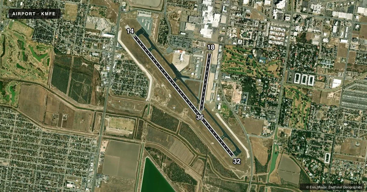
Airport sketch
Runways drawn to scale from FAA survey coordinates, rendered over satellite imagery. Not for navigation.
Approaches & charts
ILS · 2
Services on the field
Fuel grades, oxygen, maintenance, ramp storage and lighting — as declared to the FAA by the airport operator.
Fuel & services
- Fuel
- 100LLA
- Oxygen (bottled)
- High pressure
- Airframe repair
- Major
- Power plant repair
- Major
- Other services
- AMB,AVNCS,CHTR,INSTR,RNTL,SALES
Ramp & ground
- Transient storage
- Tie-down
- Hangar
- Landing fee
- No fee published
- Customs
- Available
- Lighting schedule
- SEE RMK
- Beacon schedule
- SS-SR
- Beacon
- White / Green (civil land)(WG)
- Wind indicator
- Lighted
- Segmented circle
- Yes
Fuel & FBOs
Cheapest 100LL and Jet A on the field and nearby. Always confirm with the FBO before taxi.
Airport notes
Surface conditions, obstructions, local procedures, lighting outages and other notes published with each FAA cycle.
General notes
- FOR ARFF WHEN ATCT CLSD CTC, MC ALLEN ARPT OPNS 956-681-1500.
- NO 180 DEGS LOCKED WHEEL TURNS ON RWY 14/32.
- BIRDS ON & INVOF ARPT (SEASONAL).
- JET OR LARGE PROPELLER ACFT TRNG PROHIBITED (INCLUDING PRACTICE APCHS; TGL & PRACTICE INSTRUMENT APCH PROCS) DUE TO NOISE ABATEMENT PROCEDURES EFFECT 2300-0600.
- WHEN DEPARTING ARPT FLY RWY HDG UNTIL REACHING 1000 FT AGL BFR MAKING PT.
- TWY C BTN TWY C2 AND THE APCH END OF RWY 18 NOT VSB FM ATCT.
- FOR CD WHEN ATCT IS CLSD CTC CRP APCH AT 361-299-4230.
- NO ACFT ENG RUN-UPS ON TRML APN.
Lighting notes
- WHEN ATCT CLSD ACTVT MALSR RWY 14; HIRL RWY 14/32; MIRL RWY 18/36 - CTAF.
Runway surface & condition
- 14/32PCR VALUE: 880/F/A/X/T
- 18/36PCR VALUE: 330/F/C/X/T
- 18/36RWY 18/36 NOT AVBL FOR PART 121/PART 380 OPS WITH SKED PAX CARRYING OPS MORE THAN 9 PAX SEATS AND NON-SKED PAX CARRYING OPS MORE THAN 30 PAX SEATS.
Approach & departure obstructions
- 18PAPI OTS INDEFLY.
- 14APCH RATIO 37:1 FM DSPLCD THR.
Other notes
- 1FOR SVCS AFT HRS CALL 956-686-1774.
VFR map & nearby airports
VFR sectional. Tap any ICAO chip to open that airport.
Key facts · KMFE
Answer card- ICAO
- KMFE
- Name
- MC ALLEN INTL
- Location
- MC ALLEN, TEXAS
- Elevation
- 107.2 ft MSL
- Traffic pattern altitude
- 1,107.2 ft MSL (1,000 AGL)
- Control tower
- Towered · 0600-0000
- Total runways
- 2
- Longest runway
- 14/32 · 7,120 ft
- Published ILS approaches
- 2
- Published frequencies
- 10
- Magnetic variation
- 4°
- Current flight rules
- VFR
- Current wind
- 150° at 14 kt
- Favored runway now
- RWY 14
Mc Allen Intl is in Mc Allen, Texas. The field elevation is 107.2 ft MSL. It has two asphalt runways. The longest is runway 14/32 at 7,120 ft. The airport has a control tower. Tower hours are 0600 to 0000.
Two ILS approaches are published. They serve runway ends 14 and 32. Pattern altitude is not published in the facts, so plan on the standard 1,000 ft AGL for light piston traffic unless the current FAA Chart Supplement says otherwise. McCreery Aviation is on the field. It carries 100LL, Jet A and Jet A Prist. Call (956) 627-1990 for current service details.
A few operational notes matter here. Birds are reported seasonally in and around the airport. Runway 18/36 is not available for certain scheduled passenger operations with larger aircraft. Taxiway C between C2 and the approach end of runway 18 is not visible from the tower. Runway 18 has an out-of-service PAPI. When the tower is closed, use the published lighting activation procedures on CTAF. Noise abatement is active from 2300 to 0600. Jet and large prop training is prohibited during that window. Departing aircraft are expected to fly runway heading until 1,000 ft AGL before turning.