METAR & TAF KALI
Current METAR
Observed 12:53Z
KALI 271253Z AUTO 16008KT 8SM CLR 24/24 A2995 RMK AO2 SLP139 T02440239
- Wind
- 160° @ 8 kt
- Visibility
- 8 SM
- Temp / Dew
- 24°C / 24°C
- Altimeter
- 29.95 inHg
- Clouds
- CLR
- Density alt
- 1,264 ft
- Ceiling
- Unlimited
- Rules
- VFR
Airport info & contacts
Manager on record, flight service, ARTCC, attendance schedule and pattern altitude — published by the FAA and refreshed every 28 days.
Location
- From city
- 3 NM SE
- VFR sectional
- BROWNSVILLE
- ARTCC
- ZHU · HOUSTON
- NOTAM facility
- ALI (NOTAM-D)
Airport manager
- Name
- MICHAEL ESPARZA
- Phone
- 361-453-1721
- Address
- PO DRAWER 3229, ALICE TX 78333
Flight service · Hours
- FSS SJT
- SAN ANGELO1-800-WX-BRIEF
- Attendance
- 0800-1700
Frequencies
Tap any row to copy the frequency to your clipboard.
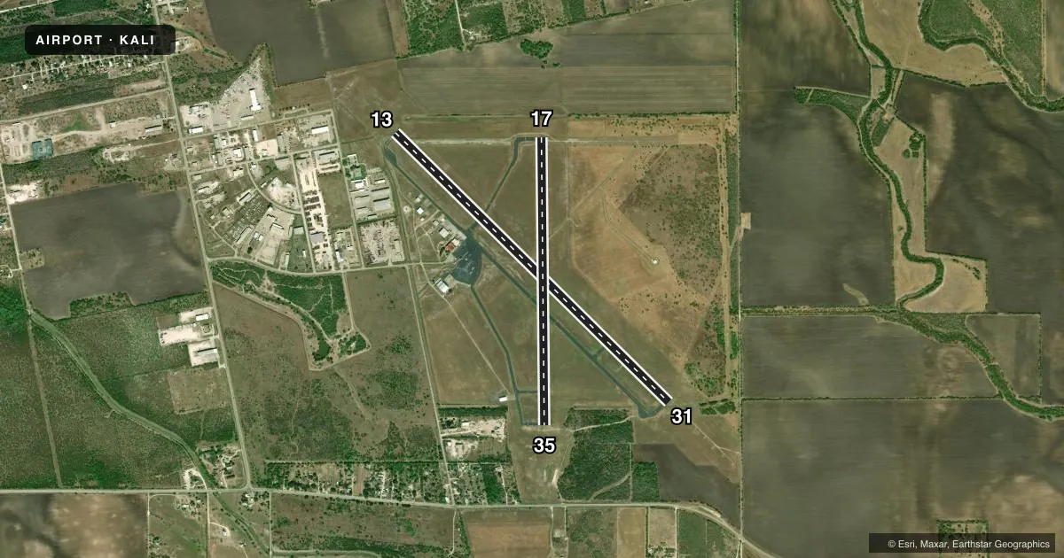
Runways & pattern
Full pagePattern entry · RWY 17
LEFT TRAFFIC| Runway | Heading (°M) | Length | Surface | Traffic |
|---|---|---|---|---|
| 13/31 | 128° / 308° | 5,997 ft | ASPH | Standard L |
| 17/35Favored | 173° / 353° | 4,490 ft | ASPH | Standard L |
Runway end performance
| End | TORA | TODA | ASDA | LDA | VGSI | Approach lights | Obstruction |
|---|---|---|---|---|---|---|---|
| 13 | — | — | — | — | PAPI 4-box left(3°) | — | 15', road, 690' from thr, 570' R of cntrln, slope 32 |
| 31 | — | — | — | — | — | MALS | — |
| 17 | — | — | — | — | PAPI 2-box left(3°) | — | — |
| 35 | — | — | — | — | PAPI 2-box left(3°) | — | 30', pline, 1300' from thr, 0' R of cntrln, slope 36 |
Declared distances in feet. TORA = takeoff run available, TODA = takeoff distance, ASDA = accelerate-stop, LDA = landing distance.
Airport sketch
Runways drawn to scale from FAA survey coordinates, rendered over satellite imagery. Not for navigation.
Approaches & charts
ILS · 1
Services on the field
Fuel grades, oxygen, maintenance, ramp storage and lighting — as declared to the FAA by the airport operator.
Fuel & services
- Fuel
- 100LLA
- Oxygen (bottled)
- HIGH/LOW
- Oxygen (bulk)
- HIGH/LOW
Ramp & ground
- Transient storage
- Tie-down
- Hangar
- Landing fee
- No fee published
- Customs
- Not available
- Lighting schedule
- SEE RMK
- Beacon schedule
- SS-SR
- Beacon
- White / Green (civil land)(WG)
- Wind indicator
- Yes
- Segmented circle
- Yes
Fuel & FBOs
Cheapest 100LL and Jet A on the field and nearby. Always confirm with the FBO before taxi.
Airport notes
Surface conditions, obstructions, local procedures, lighting outages and other notes published with each FAA cycle.
General notes
- FOR CD IF UNA TO CTC ON FSS FREQ, CTC HOUSTON ARTCC AT 281-230-5622.
Lighting notes
- ACTVT MALS RWY 31; REILS RWY 13; PAPI RWY 17 & 35 - CTAF. MIRL RWYS 13/31 & 17/35 PRESET LOW INTST DUSK-2300; TO INCR INTST OR ACTVT AFT 2300 - CTAF.
Fuel notes
- 100LL100LL AVBL 24 HRS AT SELF-SVC PUMP.
Approach & departure obstructions
- 31RWY MKGS DISCOLORED.
Other notes
- THIS AIRPORT HAS BEEN SURVEYED BY THE NATIONAL GEODETIC SURVEY.
- 2AFT HRS SVC, CALL 361-664-2656.
- MANAGERCITY/ARPT MGR. ON SITE MGR TIM THOMPSON 361-453-1731.
VFR map & nearby airports
VFR sectional. Tap any ICAO chip to open that airport.
Key facts · KALI
Answer card- ICAO
- KALI
- Name
- ALICE INTL
- Location
- ALICE, TEXAS
- Elevation
- 178.2 ft MSL
- Traffic pattern altitude
- 1,178.2 ft MSL (1,000 AGL)
- Control tower
- Non-towered (use CTAF)
- Total runways
- 2
- Longest runway
- 13/31 · 5,997 ft
- Published ILS approaches
- 1
- Published frequencies
- 5
- Magnetic variation
- 6°
- Current flight rules
- VFR
- Current wind
- 160° at 8 kt
- Favored runway now
- RWY 17
Alice Intl sits in Alice, Texas. Field elevation is 178.2 ft MSL. The airport has two asphalt runways. The longest is 13/31 at 5,997 ft. This is an uncontrolled field with no tower. CTAF and UNICOM are both 123.0. The published ILS serves runway 31. Pattern altitude is not published, so use standard 1,000 ft AGL for light piston traffic unless the current Chart Supplement says otherwise.
KALI Aviation is on the field. It carries JET A and JET A Prist. 100LL is available 24 hours at the self-service pump. After hours service is available by calling the field number. Runway lighting details matter here. Runway 31 has medium intensity approach lighting. Runway 13 has runway end identifier lights. Runways 17 and 35 have PAPI. The runway lights are preset to low intensity from dusk to 2300. Use CTAF to raise intensity or activate lights after 2300.
For a first-time arrival, the main things to plan for are the uncontrolled pattern, the published ILS to 31 and the lighting setup after dark. Clearance delivery notes point pilots to Houston ARTCC if Flight Service cannot be reached. The airport sits at low elevation in South Texas, so density altitude is usually less of a concern than at high fields. Still, check the current weather and performance before you go.