METAR & TAF 67T
67T does not publish a METAR.
Showing the nearest reporting station: KRBO (NUECES COUNTY) · 8.6 NM away. Conditions at 67T may differ.
METAR · KRBO
Observed 13:15Z
KRBO 271315Z AUTO 14004KT A2997 RMK AO2 PWINO
- Wind
- 140° @ 4 kt
- Visibility
- —
- Temp / Dew
- —
- Altimeter
- 29.97 inHg
- Clouds
- Clear
- Density alt
- —
- Ceiling
- Unlimited
- Rules
- VFR
Airport info & contacts
Manager on record, flight service, ARTCC, attendance schedule and pattern altitude — published by the FAA and refreshed every 28 days.
Location
- From city
- 3 NM E
- VFR sectional
- BROWNSVILLE
- ARTCC
- ZHU · HOUSTON
- NOTAM facility
- SJT (NOTAM-D)
Airport manager
- Name
- DOUG WILLIAMS
- Phone
- 361-998-2516
- Address
- 3673 CR 93, AGUA DULCE TX 78330
Flight service · Hours
- FSS SJT
- SAN ANGELO1-800-WX-BRIEF
- Attendance
- MON-FRI · 0800-1630
Frequencies
Tap any row to copy the frequency to your clipboard.
Runways & pattern
Full pagePattern entry · RWY 16
LEFT TRAFFICRunway end performance
| End | TORA | TODA | ASDA | LDA | VGSI | Approach lights | Obstruction |
|---|---|---|---|---|---|---|---|
| 16 | — | — | — | — | VASI 2-box left(3°) | — | — |
| 34 | — | — | — | — | VASI 2-box left(3.75°) | — | 1512', pole, 210' from thr, 68' R of cntrln, slope 0 |
Declared distances in feet. TORA = takeoff run available, TODA = takeoff distance, ASDA = accelerate-stop, LDA = landing distance.
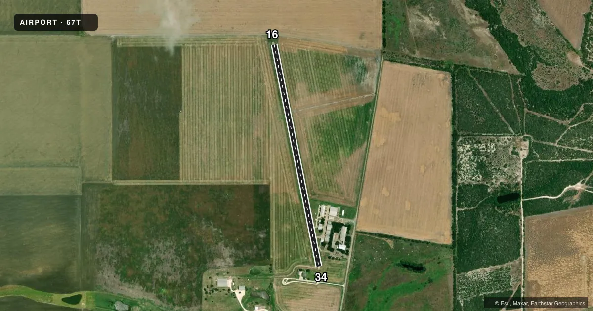
Airport sketch
Runways drawn to scale from FAA survey coordinates, rendered over satellite imagery. Not for navigation.
Approaches & charts
Services on the field
Fuel grades, oxygen, maintenance, ramp storage and lighting — as declared to the FAA by the airport operator.
Fuel & services
- Fuel
- Not available
Ramp & ground
- Transient storage
- Tie-down
- Hangar
- Landing fee
- Yes
- Lighting schedule
- SEE RMK
- Beacon schedule
- SEE RMK
- Beacon
- White / Green (civil land)(WG)
- Wind indicator
- Lighted
- Segmented circle
- No
Fuel & FBOs
Cheapest 100LL and Jet A on the field and nearby. Always confirm with the FBO before taxi.
Airport notes
Surface conditions, obstructions, local procedures, lighting outages and other notes published with each FAA cycle.
General notes
- WILDLIFE ON AND INVOF ARPT.
- FOR CD CTC HOUSTON ARTCC AT 281-230-5622.
- RWY 34, 99 FT AGL LGTD TWR 0.35 MILE SSE, 140 FT L OF RWY CNTRLN.
Lighting notes
- BEACON DUSK-0100.
- FOR REIL RWY 16 & 34; VASI RWY 16 & 34; LIRL RWY 16/34 - PRIOR ARNGMTS RQRD. CALL 361-998-2516.
Runway surface & condition
- 16/34RWY LGTS SRNDD BY 18 IN HIGH STAKES AND RAZOR WIRE.
Approach & departure obstructions
- 163 FT SIGN & 2 FT BOLLARD, 160 FT DSTC.
- 348 FT FENCE 0-199 FT DSTC 68 FT L.
- 16REIL ARE NON-FRANGIBLE AND ARE SRNDD WITH 18 INCH RAZOR WIRE.
- 34REIL ARE NON-FRANGIBLE AND ARE SRNDD WITH 18 INCH HIGH RAZOR WIRE.
- 16VASI SRNDD BY 2 FT HIGH RAZOR WIRE.
- 34VASI SRNDD BY 2 FT HIGH RAZOR WIRE.
- 16CTLG OBSTN EXCEEDS A 45 DEG SLOPE.
Other notes
- 16/34RWYS 16 AND 34 HAVE 40 FT BLAST PADS 30 FT WIDE.
VFR map & nearby airports
VFR sectional. Tap any ICAO chip to open that airport.
Key facts · 67T
Answer card- ICAO
- 67T
- Name
- OLD HOPPE PLACE
- Location
- AGUA DULCE, TEXAS
- Elevation
- 96 ft MSL
- Traffic pattern altitude
- 1,096 ft MSL (1,000 AGL)
- Control tower
- Non-towered (use CTAF)
- Total runways
- 1
- Longest runway
- 16/34 · 3,164 ft
- Published ILS approaches
- 0
- Published frequencies
- 1
- Magnetic variation
- 6°
- Current flight rules
- VFR
- Current wind
- 140° at 4 kt
- Favored runway now
- RWY 16
Old Hoppe Place (67T) is in Agua Dulce, Texas. The field elevation is 96 ft MSL. It has one runway. Runway 16/34 is 3,164 ft long with a concrete surface. There is no control tower. CTAF is 122.9.
No ILS approaches are published here. The pattern altitude is not published, so use the current FAA Chart Supplement before you fly. The airport sits in a low coastal Texas environment. Expect wildlife in and around the field. That matters on taxi, takeoff and landing.
Published remarks show some items that need planning. Prior arrangements are required for runway end identifier lights, VASI and low intensity runway lights. Call 361-998-2516 before arrival if you need lighting support. Runway 34 has a 99 ft lighted tower 0.35 mile south-southeast and 140 ft left of centerline. Runway 34 also has an 8 ft fence close in on the left side. Runway 16 has an obstruction that exceeds a 45 degree slope. The beacon operates from dusk to 0100. No on-field FBOs are listed. Contact the airport operator directly before arrival.