METAR & TAF KBEA
Current METAR
Observed 18:55Z
KBEA 071855Z AUTO 16011G20KT 10SM TS SCT045 BKN050 BKN095 32/21 A3005 RMK AO2 LTG DSNT NW THRU E T03200205
- Wind
- 160° @ 11G20 kt
- Visibility
- 10 SM
- Temp / Dew
- 32°C / 21°C
- Altimeter
- 30.05 inHg
- Clouds
- BKN
- Density alt
- 2,217 ft
- Ceiling
- 5,000 ft AGL
- Rules
- VFR
Airport info & contacts
Manager on record, flight service, ARTCC, attendance schedule and pattern altitude — published by the FAA and refreshed every 28 days.
Location
- From city
- 3 NM SW
- VFR sectional
- SAN ANTONIO
- ARTCC
- ZHU · HOUSTON
- NOTAM facility
- BEA (NOTAM-D)
Airport manager
- Name
- JOHN BENSON
- Phone
- 361-358-4641
- Address
- 400 N. WASHINGTON, BEEVILLE TX 78102
Flight service · Hours
- FSS SJT
- SAN ANGELO1-800-WX-BRIEF
- Attendance
- Unattended
Frequencies
Tap any row to copy the frequency to your clipboard.
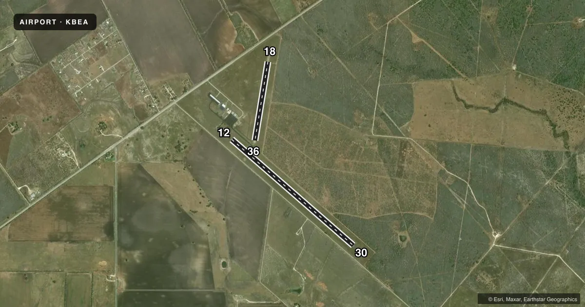
Runways & pattern
Full pagePattern entry · RWY 12
LEFT TRAFFIC| Runway | Heading (°M) | Length | Surface | Traffic |
|---|---|---|---|---|
| 12/30Favored | 127° / 307° | 4,553 ft | ASPH | Standard L |
| 18/36 | 185° / 5° | 2,251 ft | TURF | Standard L |
Runway end performance
| End | TORA | TODA | ASDA | LDA | VGSI | Approach lights | Obstruction |
|---|---|---|---|---|---|---|---|
| 12 | — | — | — | — | PAPI 2-box left(3°) | — | 15', road, 260' from thr, 260' R of cntrln, slope 4 |
| 30 | — | — | — | — | PAPI 2-box left(3°) | — | 15', road, 258' from thr, 264' R of cntrln, slope 3 |
| 18 | — | — | — | — | — | — | 20', pline, 450' from thr, 200' R of cntrln, slope 22 |
| 36 | — | — | — | — | — | — | 21', pline, 675' from thr, 180' R of cntrln, slope 32 |
Declared distances in feet. TORA = takeoff run available, TODA = takeoff distance, ASDA = accelerate-stop, LDA = landing distance.
Airport sketch
Runways drawn to scale from FAA survey coordinates, rendered over satellite imagery. Not for navigation.
Approaches & charts
Services on the field
Fuel grades, oxygen, maintenance, ramp storage and lighting — as declared to the FAA by the airport operator.
Fuel & services
- Fuel
- 100LLA+
- Oxygen (bottled)
- Not available
- Oxygen (bulk)
- Not available
- Airframe repair
- Minor
- Power plant repair
- Minor
Ramp & ground
- Transient storage
- Tie-down
- Landing fee
- No fee published
- Customs
- Not available
- Lighting schedule
- SEE RMK
- Beacon schedule
- SS-SR
- Beacon
- White / Green (civil land)(WG)
- Wind indicator
- Lighted
- Segmented circle
- Yes
Fuel & FBOs
Cheapest 100LL and Jet A on the field and nearby. Always confirm with the FBO before taxi.
Airport notes
Surface conditions, obstructions, local procedures, lighting outages and other notes published with each FAA cycle.
General notes
- FOR CD CTC HOUSTON ARTCC AT 281-230-5622.
- ON SITE ATTENDANT TIM FITCH, TIMAFITCH@GMAIL.COM, 361-319-3448. ALSO LARRY CLINE 361-542-6544.
Lighting notes
- SS-SR MIRL RY 12/30 PRESET LOW INTST; TO INCR INTST ACTVT - CTAF.
Fuel notes
- 100LLFUEL 24 HR SELF SERV.
Approach & departure obstructions
- 18MKD WITH 3 FT YELLOW CONES.
- 12ALSO 30 FT PLINE, 464 FT DSTC, 295 FT R, OBSTN CLNC SLOPE 8:1. ALSO 30 FT PLINE, 445 FT DSTC, 290 FT R, OBSTN CLNC SLOPE 8:1.
Other notes
- MANAGERAMGR CELL: 361-742-7725
VFR map & nearby airports
VFR sectional. Tap any ICAO chip to open that airport.
Key facts · KBEA
Answer card- ICAO
- KBEA
- Name
- BEEVILLE MUNI
- Location
- BEEVILLE, TEXAS
- Elevation
- 272.8 ft MSL
- Traffic pattern altitude
- 1,272.8 ft MSL (1,000 AGL)
- Control tower
- Non-towered (use CTAF)
- Total runways
- 2
- Longest runway
- 12/30 · 4,553 ft
- Published ILS approaches
- 0
- Published frequencies
- 2
- Magnetic variation
- 4°
- Current flight rules
- VFR
- Current wind
- 160° at 11 kt
- Favored runway now
- RWY 12
Beeville Muni sits in Beeville, Texas at 272.8 ft MSL. It has two runways. The longest is runway 12/30 at 4,553 ft. Runway 18/36 is turf and measures 2,251 ft. The field is non-towered. Traffic calls go on CTAF 122.8. UNICOM is also 122.8. No ILS approaches are published here.
Pattern altitude is not published. For light piston operations, plan on 1,000 ft AGL unless the current Chart Supplement says otherwise. The airport has 24-hour self-serve 100LL at Beeville Air Services. That FBO also carries JET A. It is the on-field fuel stop. On-site attendants are listed in the published remarks if you need local help on the ground.
A few operational items matter here. Runway 18 is marked with 3 foot yellow cones. There are also two 30 foot power lines near the field with published obstruction clearance slopes. The runway 12/30 lights are preset to low intensity from sunset to sunrise. Use CTAF to increase intensity. If you need clearance delivery, Houston ARTCC handles it. First-time arrivals should brief the turf runway. They should also brief the power line notes and the lighting setup before taxi.