METAR & TAF TX2
TX2 does not publish a METAR.
Showing the nearest reporting station: KBEA (BEEVILLE MUNI) · 6.9 NM away. Conditions at TX2 may differ.
METAR · KBEA
Observed 18:55Z
KBEA 071855Z AUTO 16011G20KT 10SM TS SCT045 BKN050 BKN095 32/21 A3005 RMK AO2 LTG DSNT NW THRU E T03200205
- Wind
- 160° @ 11G20 kt
- Visibility
- 10 SM
- Temp / Dew
- 32°C / 21°C
- Altimeter
- 30.05 inHg
- Clouds
- BKN
- Density alt
- 2,107 ft
- Ceiling
- 5,000 ft AGL
- Rules
- VFR
Airport info & contacts
Manager on record, flight service, ARTCC, attendance schedule and pattern altitude — published by the FAA and refreshed every 28 days.
Location
- From city
- 5 NM SE
- VFR sectional
- SAN ANTONIO
- ARTCC
- ZHU · HOUSTON
- NOTAM facility
- SJT (NOTAM-D)
Airport manager
- Name
- MICHAEL BLAIR
- Phone
- 361-358-2023
- Address
- 2745 BROWN LN, BEEVILLE TX 78102
Flight service · Hours
- FSS SJT
- SAN ANGELO1-800-WX-BRIEF
- Attendance
- Unattended
Frequencies
Tap any row to copy the frequency to your clipboard.
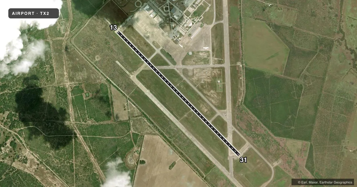
Runways & pattern
Full pagePattern entry · RWY 13
LEFT TRAFFICRunway end performance
| End | TORA | TODA | ASDA | LDA | VGSI | Approach lights | Obstruction |
|---|---|---|---|---|---|---|---|
| 13 | — | — | — | — | — | — | 16', trees, 222' from thr, 155' R of cntrln, slope 1 |
Declared distances in feet. TORA = takeoff run available, TODA = takeoff distance, ASDA = accelerate-stop, LDA = landing distance.
Airport sketch
Runways drawn to scale from FAA survey coordinates, rendered over satellite imagery. Not for navigation.
Approaches & charts
Services on the field
Fuel grades, oxygen, maintenance, ramp storage and lighting — as declared to the FAA by the airport operator.
Fuel & services
- Fuel
- A
Ramp & ground
- Transient storage
- Not published
- Lighting schedule
- SEE RMK
- Beacon schedule
- SS-SR
- Beacon
- White / Green (civil land)(WG)
- Wind indicator
- Yes
- Segmented circle
- No
Fuel & FBOs
Cheapest 100LL and Jet A on the field and nearby. Always confirm with the FBO before taxi.
Airport notes
Surface conditions, obstructions, local procedures, lighting outages and other notes published with each FAA cycle.
General notes
- FOR CD CTC HOUSTON ARTCC AT 281-230-5622.
- ARPT FENCED, GATES LOCKED. FOR ACES CALL AMGR.
- THE PREV PARL RWY 13R/31L CLSD.
Lighting notes
- MIRL RWY 13/31 PRESET TO LOW INTST SS-SR; TO INCR INTST AND ACTVT - CTAF.
Fuel notes
- AJET A 24 HR. SELF-SERVE.
Approach & departure obstructions
- 135 FT BRUSH, 0-100 FT DSTC, 130-250 FT R.
- 13MKG FADED, COVERED BY RUBBER DEPOSITS IN SOME AREAS.
- 31MKG FADED, COVERED BY RUBBER DEPOSITS IN SOME AREAS.
Other notes
- MANAGER480-244-2857 MGR CELL.
- 13/31SOME AREAS OF LOOSE STONES
VFR map & nearby airports
VFR sectional. Tap any ICAO chip to open that airport.
Key facts · TX2
Answer card- ICAO
- TX2
- Name
- CHASE FLD INDUSTRIAL
- Location
- BEEVILLE, TEXAS
- Elevation
- 184.2 ft MSL
- Traffic pattern altitude
- 1,184.2 ft MSL (1,000 AGL)
- Control tower
- Non-towered (use CTAF)
- Total runways
- 1
- Longest runway
- 13/31 · 8,000 ft
- Published ILS approaches
- 0
- Published frequencies
- 2
- Magnetic variation
- 4°
- Current flight rules
- VFR
- Current wind
- 160° at 11 kt
- Favored runway now
- RWY 13
Chase Fld Industrial (TX2) sits in Beeville, Texas. Field elevation is 184.2 ft MSL. The airport has one runway. Runway 13/31 is 8,000 ft asphalt, which gives you plenty of pavement for most light and medium traffic. There is no control tower. CTAF and UNICOM are both 122.8. No ILS approaches are published here.
Pattern altitude is not published. Use 1,000 ft AGL as the standard light-piston pattern unless the current Chart Supplement says otherwise. The airport is fenced and the gates are locked, so plan ahead for access. Call the airport manager if you need entry. The manager’s cell number is published in the Chart Supplement remarks. Houston ARTCC handles clearance delivery for this field.
A few runway notes matter here. Markings on both runway ends are faded in places. Rubber deposits are noted on the pavement. There is also some loose stone on runway 13/31. Brush is reported near runway 13, off the right side. The previous parallel runway 13R/31L is closed. Medium intensity runway lights on 13/31 are preset low from sunset to sunrise. Use CTAF to increase intensity and activate them. Jet A is available 24 hours self-serve. No on-field FBOs are listed.