METAR & TAF 2R9
Current METAR
Observed 09:35Z
K2R9 260935Z AUTO 00000KT 2SM BR VV007 24/23 A3003 RMK AO2 VIS 3/4V5
- Wind
- 000° @ 0 kt
- Visibility
- 2 SM
- Temp / Dew
- 24°C / 23°C
- Altimeter
- 30.03 inHg
- Clouds
- VV
- Density alt
- 1,302 ft
- Ceiling
- 700 ft AGL
- Rules
- IFR
Airport info & contacts
Manager on record, flight service, ARTCC, attendance schedule and pattern altitude — published by the FAA and refreshed every 28 days.
Location
- From city
- 1 NM NW
- VFR sectional
- SAN ANTONIO
- ARTCC
- ZHU · HOUSTON
- NOTAM facility
- SJT (NOTAM-D)
Airport manager
- Name
- RON HYDE
- Phone
- 830-583-5930
- Address
- 356 AIRPORT RD, P.O. BOX 569, KENEDY TX 78119
Flight service · Hours
- FSS SJT
- SAN ANGELO1-800-WX-BRIEF
- Attendance
- MON-FRI · DALGT
Frequencies
Tap any row to copy the frequency to your clipboard.
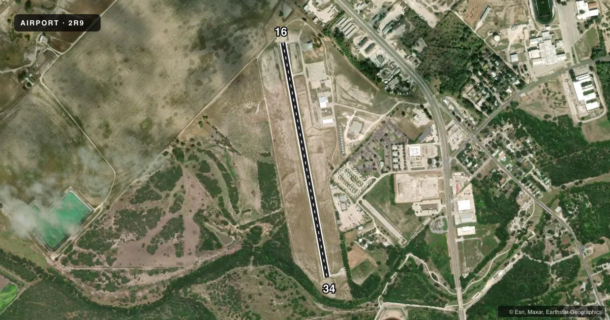
Runways & pattern
Full pagePattern entry · RWY 16
RIGHT TRAFFICRunway end performance
| End | TORA | TODA | ASDA | LDA | VGSI | Approach lights | Obstruction |
|---|---|---|---|---|---|---|---|
| 16 | — | — | — | — | PAPI 2-box left(3°) | — | 8', fence, 201' from thr, 204' R of cntrln, slope 0 |
| 34 | — | — | — | — | PAPI 2-box left(3.6°) | — | 16', trees, 201' from thr, 250' R of cntrln, slope 0 |
Declared distances in feet. TORA = takeoff run available, TODA = takeoff distance, ASDA = accelerate-stop, LDA = landing distance.
Airport sketch
Runways drawn to scale from FAA survey coordinates, rendered over satellite imagery. Not for navigation.
Approaches & charts
Services on the field
Fuel grades, oxygen, maintenance, ramp storage and lighting — as declared to the FAA by the airport operator.
Fuel & services
- Fuel
- 100LLA
- Airframe repair
- Major
- Power plant repair
- Major
- Other services
- INSTR
Ramp & ground
- Transient storage
- Tie-down
- Landing fee
- No fee published
- Customs
- Not available
- Lighting schedule
- SEE RMK
- Beacon schedule
- SS-SR
- Beacon
- White / Green (civil land)(WG)
- Wind indicator
- Lighted
- Segmented circle
- Yes
Fuel & FBOs
Cheapest 100LL and Jet A on the field and nearby. Always confirm with the FBO before taxi.
Airport notes
Surface conditions, obstructions, local procedures, lighting outages and other notes published with each FAA cycle.
General notes
- DEER ON & INVOF ARPT.
- ACFT AIRFRAME & POWER PLANT REPAIRS ON CALL 830-299-2295.
- FOR CD CTC HOUSTON ARTCC AT 281-230-5622.
Lighting notes
- MIRL RWY 16/34 & TWY LGTS PRESET LOW INTST; TO INCR INTST ACTVT - CTAF.
Approach & departure obstructions
- 168 FT FENCE, 30-199 FT DSTC, 202 FT R.
- 348FT FENCE 0-199 DSTC, 34 FT TREES, 0-199 FT DSTC, 120-250 FT L.
- 34RSTRD 7 DEGS LEFT DUE TO OBSTS.
- 16CONTROLLING OBSTRUCTION EXCEEDS A 45 DEGREE SLOPE
VFR map & nearby airports
VFR sectional. Tap any ICAO chip to open that airport.
Key facts · 2R9
Answer card- ICAO
- 2R9
- Name
- KENEDY RGNL
- Location
- KENEDY, TEXAS
- Elevation
- 288.7 ft MSL
- Traffic pattern altitude
- 1,288.7 ft MSL (1,000 AGL)
- Control tower
- Non-towered (use CTAF)
- Total runways
- 1
- Longest runway
- 16/34 · 3,218 ft
- Published ILS approaches
- 0
- Published frequencies
- 2
- Magnetic variation
- 5°
- Current flight rules
- IFR
- Current wind
- 000° at 0 kt
- Favored runway now
- –
KENEDY RGNL sits in Kenedy, Texas. Field elevation is 288.7 ft MSL. The airport has one runway. Runway 16/34 is 3,218 ft of asphalt. That is the longest runway on the field. There is no control tower. CTAF and UNICOM are both 123.0. No ILS approaches are published.
Pattern altitude is not published. For light piston traffic, use the standard 1,000 ft AGL pattern unless the current Chart Supplement or local procedures say otherwise. The published remarks matter here. Runway 16 has a controlling obstruction that exceeds a 45 degree slope. Runway 34 is restricted 7 degrees left because of obstructions. Near runway 34 there is an 8-foot fence, 34-foot trees and more trees off the left side. Near runway 16 there is also an 8-foot fence to the right. Deer are reported on and near the airport. Keep a sharp scan on taxi, takeoff and landing.
Stetson Aviation is on the field. It carries 100LL and Jet A Prist. Medium intensity runway lights and taxiway lights are preset to low intensity. Use the CTAF to increase intensity. For clearance delivery, contact Houston ARTCC at 281-230-5622. Aircraft airframe and power plant repairs are available on call.