METAR & TAF 8T6
Current METAR
Observed 11:55Z
K8T6 271155Z AUTO 12005KT 6SM BR SCT017 24/24 A2995 RMK AO2
- Wind
- 120° @ 5 kt
- Visibility
- 6 SM
- Temp / Dew
- 24°C / 24°C
- Altimeter
- 29.95 inHg
- Clouds
- SCT
- Density alt
- 1,202 ft
- Ceiling
- Unlimited
- Rules
- VFR
Airport info & contacts
Manager on record, flight service, ARTCC, attendance schedule and pattern altitude — published by the FAA and refreshed every 28 days.
Location
- From city
- 2 NM N
- VFR sectional
- SAN ANTONIO
- ARTCC
- ZHU · HOUSTON
- NOTAM facility
- SJT (NOTAM-D)
Airport manager
- Name
- JAMES LISKA
- Phone
- 361-449-8002
- Address
- 301 HOUSTON ST, PO BOX 487, GEORGE WEST TX 78022
Flight service · Hours
- FSS SJT
- SAN ANGELO1-800-WX-BRIEF
- Attendance
- Unattended
Frequencies
Tap any row to copy the frequency to your clipboard.
Runways & pattern
Full pagePattern entry · RWY 13
LEFT TRAFFICRunway end performance
| End | TORA | TODA | ASDA | LDA | VGSI | Approach lights | Obstruction |
|---|---|---|---|---|---|---|---|
| 13 | — | — | — | — | PAPI 2-box left(3°) | — | 50', pline, 1361' from thr, 264' R of cntrln, slope 23 |
| 31 | — | — | — | — | PAPI 2-box left(3°) | — | — |
Declared distances in feet. TORA = takeoff run available, TODA = takeoff distance, ASDA = accelerate-stop, LDA = landing distance.
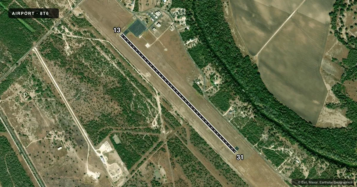
Airport sketch
Runways drawn to scale from FAA survey coordinates, rendered over satellite imagery. Not for navigation.
Approaches & charts
Services on the field
Fuel grades, oxygen, maintenance, ramp storage and lighting — as declared to the FAA by the airport operator.
Fuel & services
- Fuel
- 100LLA
Ramp & ground
- Transient storage
- Tie-down
- Lighting schedule
- SEE RMK
- Beacon schedule
- SS-SR
- Beacon
- White / Green (civil land)(WG)
- Wind indicator
- Lighted
- Segmented circle
- Yes
Fuel & FBOs
Cheapest 100LL and Jet A on the field and nearby. Always confirm with the FBO before taxi.
Airport notes
Surface conditions, obstructions, local procedures, lighting outages and other notes published with each FAA cycle.
General notes
- BIRDS ON & INVOF ARPT.
- FOR CD CTC HOUSTON ARTCC AT 281-230-5622.
- 75 FT ELEC TRANSMISSION LINE, 600 FT W OF AND PARL TO RWY CNTRLN, FULL LEN.
- FOR ASSISTANCE OR HNGR CALL 361-449-2559 OR 361-449-6315 (CELL).
Lighting notes
- DUSK-DAWN. MIRL RWY 13/31 PRESET LOW INTST; TO INCR INTST ACTVT - 122.7.
Fuel notes
- 100LLFUEL SELF-SERVE.
Other notes
- PRVDD EXISTING LIVE OAK COUNTY APT CLOSES PRIOR TO COMMENCEMENT OF FLIGHT OPNS AT NEW SITE.
- MANAGERCOUNTY JUDGE
- ON A/P MGRLTDAVIS@LIVE.COM ALT 361-449-2093
VFR map & nearby airports
VFR sectional. Tap any ICAO chip to open that airport.
Key facts · 8T6
Answer card- ICAO
- 8T6
- Name
- LIVE OAK COUNTY
- Location
- GEORGE WEST, TEXAS
- Elevation
- 128.7 ft MSL
- Traffic pattern altitude
- 1,128.7 ft MSL (1,000 AGL)
- Control tower
- Non-towered (use CTAF)
- Total runways
- 1
- Longest runway
- 13/31 · 3,799 ft
- Published ILS approaches
- 0
- Published frequencies
- 1
- Magnetic variation
- 3°
- Current flight rules
- VFR
- Current wind
- 120° at 5 kt
- Favored runway now
- RWY 13
Live Oak County Airport sits in George West, Texas. The field elevation is 128.7 ft MSL. It has one runway, 13/31, which is 3,799 ft long. There is no control tower. CTAF is 122.9.
No ILS approaches are published here. Pattern altitude is not published, so use standard traffic pattern altitude unless the current Chart Supplement says otherwise. The runway lighting on 13/31 is medium intensity. From dusk to dawn it is preset to low intensity. Use 122.7 to increase it.
The on-field FBO is Live Oak County Airport. It carries AVGAS 100LL and Jet A. Fuel is self-serve. Call the field at (361) 449-2733 for current service details.
A few operational items matter here. There is a 75-foot electric transmission line 600 feet west of and parallel to the runway centerline for the full length. Birds are reported on and near the airport. For clearance delivery, contact Houston ARTCC at 281-230-5622. If you need hangar or airport help, use the airport manager contact in the current Chart Supplement or call the airport directly before arrival.