METAR & TAF T69
Current METAR
Observed 09:35Z
KT69 270935Z AUTO 7SM OVC001 25/25 A2996 RMK A01
- Wind
- Calm
- Visibility
- 7 SM
- Temp / Dew
- 25°C / 25°C
- Altimeter
- 29.96 inHg
- Clouds
- OVC
- Density alt
- 1,210 ft
- Ceiling
- 100 ft AGL
- Rules
- LIFR
Airport info & contacts
Manager on record, flight service, ARTCC, attendance schedule and pattern altitude — published by the FAA and refreshed every 28 days.
Location
- From city
- 2 NM W
- VFR sectional
- SAN ANTONIO
- ARTCC
- ZHU · HOUSTON
- NOTAM facility
- SJT (NOTAM-D)
Airport manager
- Name
- GARY LEE DAVIS
- Phone
- 361-226-0112
- Address
- 3141 FM 3512, ARANSAS PASS TX 78336
Flight service · Hours
- FSS SJT
- SAN ANGELO1-800-WX-BRIEF
- Attendance
- MON-FRI · 0730-1700
Frequencies
Tap any row to copy the frequency to your clipboard.
Runways & pattern
Full pagePattern entry · RWY 14
LEFT TRAFFIC| Runway | Heading (°M) | Length | Surface | Traffic |
|---|---|---|---|---|
| 14/32 | 140° / 320° | 4,323 ft | ASPH | Standard L |
| 03/21 | 35° / 215° | 3,100 ft | TURF | Standard L |
Runway end performance
| End | TORA | TODA | ASDA | LDA | VGSI | Approach lights | Obstruction |
|---|---|---|---|---|---|---|---|
| 14 | — | — | — | — | PAPI 2-box left(3°) | — | 20', road, 201' from thr, 195' R of cntrln, slope 0 |
| 32 | — | — | — | — | PAPI 2-box left(3°) | — | 15', road, 200' from thr, 180' R of cntrln, slope 0 |
| 03 | — | — | — | — | — | — | 15', road, 78' from thr, slope 5 |
| 21 | — | — | — | — | — | — | 35', pline, 400' from thr, 0' R of cntrln, slope 11 |
Declared distances in feet. TORA = takeoff run available, TODA = takeoff distance, ASDA = accelerate-stop, LDA = landing distance.
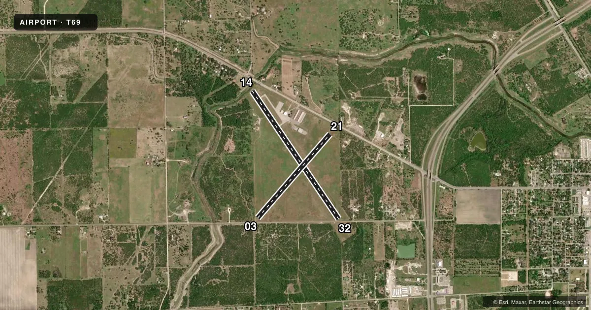
Airport sketch
Runways drawn to scale from FAA survey coordinates, rendered over satellite imagery. Not for navigation.
Approaches & charts
Services on the field
Fuel grades, oxygen, maintenance, ramp storage and lighting — as declared to the FAA by the airport operator.
Fuel & services
- Fuel
- 100LLA+
- Oxygen (bottled)
- Not available
- Oxygen (bulk)
- Not available
- Airframe repair
- Major
- Power plant repair
- Major
- Other services
- INSTR,RNTL
Ramp & ground
- Transient storage
- Tie-down
- Landing fee
- No fee published
- Customs
- Not available
- Lighting schedule
- SEE RMK
- Beacon schedule
- SS-SR
- Beacon
- White / Green (civil land)(WG)
- Wind indicator
- Lighted
- Segmented circle
- Yes
Fuel & FBOs
Cheapest 100LL and Jet A on the field and nearby. Always confirm with the FBO before taxi.
Airport notes
Surface conditions, obstructions, local procedures, lighting outages and other notes published with each FAA cycle.
General notes
- FOR CD CTC CORPUS CHRISTI APCH AT 361-299-4230.
Lighting notes
- ACTVT REIL RWYS 14 & 32; MIRL RWY 14/32 - CTAF.
Runway surface & condition
- 03/21RWY 03/21 CLSD INDEFLY.
Approach & departure obstructions
- 145 FT FENCE, 0 FT DSTC 220 FT L.
- 323 FT FENCE AND 15 FT RD 0 FT DSTC, 110 FT L.
- 14APCH RATIO 17:1 TO DSPLCD THR OVR 17 FT RD.
- 32APCH RATIO 19:1 TO DSPLCD THR OVR 15 FT RD.
- 14-25 FT CREEK BED 25 FT FM THR ACRS CNTRLN.
Other notes
- 03/21RWY NOT MNTND, NOT INSP. UNA TO DTRM EXACT LCTN OF RWY.
VFR map & nearby airports
VFR sectional. Tap any ICAO chip to open that airport.
Key facts · T69
Answer card- ICAO
- T69
- Name
- SINTON
- Location
- SINTON, TEXAS
- Elevation
- 47.9 ft MSL
- Traffic pattern altitude
- 1,047.9 ft MSL (1,000 AGL)
- Control tower
- Non-towered (use CTAF)
- Total runways
- 2
- Longest runway
- 14/32 · 4,323 ft
- Published ILS approaches
- 0
- Published frequencies
- 4
- Magnetic variation
- 6°
- Current flight rules
- LIFR
- Current wind
- Calm / unavailable
- Favored runway now
- –
Sinton Airport (T69) sits in Sinton, Texas. Field elevation is 47.9 ft MSL. The airport has two runways. The longest is 14/32 at 4,323 ft asphalt. Runway 03/21 is 3,100 ft turf, but it is closed indefinitely and not maintained or inspected. There is no control tower. CTAF and UNICOM are both 122.8. Corpus Christi Approach handles approach and departure services on 120.9 or 348.725. No ILS approaches are published here.
Pattern altitude is not published. Use the standard 1,000 ft AGL for light piston traffic unless the current Chart Supplement says otherwise. That puts the normal pattern at about 1,048 ft MSL based on the field elevation. Runway 14 has a creek bed 25 ft from the threshold across the centerline. It also has a fence near the approach side. Runway 32 has fence and road obstructions near the left side. It also has a displaced-threshold approach over a road. The runway end identifier lights and medium intensity runway lights on 14/32 are controlled by CTAF.
No on-field FBOs are listed. For fuel or service, call the numbers in the Chart Supplement before you go. If you need clearance delivery, Corpus Christi Approach is listed as the contact. First-time pilots should pay close attention to the runway 14 and 32 obstruction notes. Verify current airport status before departure.