METAR & TAF 9R5
9R5 does not publish a METAR.
Showing the nearest reporting station: KTFP (INGLESIDE RGNL) · 7.5 NM away. Conditions at 9R5 may differ.
METAR · KTFP
Observed 06:35Z
KTFP 270635Z AUTO 19009G17KT 10SM SCT018 29/25 A2998 RMK AO1 T02860251
- Wind
- 190° @ 9G17 kt
- Visibility
- 10 SM
- Temp / Dew
- 29°C / 25°C
- Altimeter
- 29.98 inHg
- Clouds
- SCT
- Density alt
- 1,653 ft
- Ceiling
- Unlimited
- Rules
- VFR
Airport info & contacts
Manager on record, flight service, ARTCC, attendance schedule and pattern altitude — published by the FAA and refreshed every 28 days.
Location
- From city
- 2 NM NW
- VFR sectional
- BROWNSVILLE
- ARTCC
- ZHU · HOUSTON
- NOTAM facility
- SJT (NOTAM-D)
Airport manager
- Name
- JANIE MITCHELL
- Phone
- 361-643-3950
- Address
- BOX 60, PORTLAND TX 78374
Flight service · Hours
- FSS SJT
- SAN ANGELO1-800-WX-BRIEF
- Attendance
- Unattended
Frequencies
Tap any row to copy the frequency to your clipboard.
Runways & pattern
Full pagePattern entry · RWY 14L
RIGHT TRAFFIC| Runway | Heading (°M) | Length | Surface | Traffic |
|---|---|---|---|---|
| 14L/32RFavored | 143° / 323° | 2,350 ft | ASPH-DIRT | 14L R |
| 14R/32L | 137° / 317° | 1,400 ft | TURF-GRVL | 14R R |
Runway end performance
| End | TORA | TODA | ASDA | LDA | VGSI | Approach lights | Obstruction |
|---|---|---|---|---|---|---|---|
| 14L | — | — | — | — | — | — | 18', road, 300' from thr, 145' R of cntrln, slope 16 |
| 32R | — | — | — | — | — | — | 10', brush, 0' from thr, 0' R of cntrln, slope 0 |
Declared distances in feet. TORA = takeoff run available, TODA = takeoff distance, ASDA = accelerate-stop, LDA = landing distance.
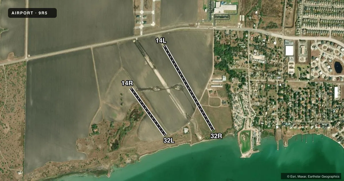
Airport sketch
Runways drawn to scale from FAA survey coordinates, rendered over satellite imagery. Not for navigation.
Approaches & charts
Services on the field
Fuel grades, oxygen, maintenance, ramp storage and lighting — as declared to the FAA by the airport operator.
Fuel & services
- Fuel
- Not available
- Oxygen (bottled)
- Not available
- Oxygen (bulk)
- Not available
Ramp & ground
- Transient storage
- Not published
- Landing fee
- No fee published
- Customs
- Not available
- Wind indicator
- Yes
- Segmented circle
- No
Fuel & FBOs
Cheapest 100LL and Jet A on the field and nearby. Always confirm with the FBO before taxi.
Airport notes
Surface conditions, obstructions, local procedures, lighting outages and other notes published with each FAA cycle.
General notes
- NOISE ABATEMENT PROCEDURES IN EFFECT - CALL ARPT MGR AT 361-643-3950.
- OWNER RESIDES ON ARPT.
- RWY 32R GND DROPS OFF APPROX 10 FT AT THR.
- FOR CD CTC CORPUS CHRISTI APCH AT 361-299-4230.
- WIND TURBINES N OF ARPT.
- CROPS ON BOTH SIDES OF RWY.
Runway surface & condition
- 14L/32RLIMITED LINE OF SIGHT BTN THRS; SOUTHERN 600 FT OF RWY DROPS OFF APPROXLY 8 FT.
- 14R/32LRWY CLSD INDEFLY.
Approach & departure obstructions
- 14LNSTD THR BAR 183 FT FM RWY END.
- 14LOBSTRUCTION CLEARANCE SLOPE EXCEEDS A 45 DEGREE ANGLE.
Other notes
- ESTAB PRIOR TO 1959.
- MANAGERJANIE511@LIVE.COM
- 14L/32RHAS SEVERE GRASS ENCROACHMENT, POT HOLES AND LOOSE GRAVEL ON RWY.
- 14R/32LHEAVY RUTTING ALONG ENTIRE RUNWAY LENGTH
- 14L/32RRWY 32 R, FIRST 200 FT TURF.
VFR map & nearby airports
VFR sectional. Tap any ICAO chip to open that airport.
Key facts · 9R5
Answer card- ICAO
- 9R5
- Name
- HUNT
- Location
- PORTLAND, TEXAS
- Elevation
- 38 ft MSL
- Traffic pattern altitude
- 1,038 ft MSL (1,000 AGL)
- Control tower
- Non-towered (use CTAF)
- Total runways
- 2
- Longest runway
- 14L/32R · 2,350 ft
- Published ILS approaches
- 0
- Published frequencies
- 1
- Magnetic variation
- 7°
- Current flight rules
- VFR
- Current wind
- 190° at 9 kt
- Favored runway now
- RWY 14L
HUNT Airport (9R5) sits in Portland, Texas. Field elevation is 38 ft MSL. The airport has 2 runways. The longest is 2,350 ft. There is no control tower. CTAF is 122.9. No ILS approaches are published here. Pattern altitude is not published, so use the standard 1,000 ft AGL for light piston operations unless the current Chart Supplement says otherwise.
Runway 14L/32R is the main paved strip. It is 2,350 ft asphalt. Published remarks say the runway has severe grass encroachment, potholes and loose gravel. The southern 600 ft drops off about 8 ft. There is also a 19-foot road across the approach at the 14L threshold. Runway 14R/32L is 1,400 ft turf-gravel. It has heavy rutting along the full length. That runway is closed indefinitely. Wind turbines are north of the airport.
No on-field FBOs are listed. Contact the airport manager before arrival. Noise abatement procedures are in effect. Call the airport manager at 361-643-3950 for current guidance. For clearance delivery, contact Corpus Christi Approach at 361-299-4230. First-time pilots should plan for a small, uncontrolled field with surface issues on the usable runway and limited line of sight between thresholds on 14L/32R.