METAR & TAF KRKP
Current METAR
Observed 00:53Z
KRKP 270053Z AUTO 15011KT 8SM FEW019 29/25 A2996 RMK AO2 SLP145 T02940250
- Wind
- 150° @ 11 kt
- Visibility
- 8 SM
- Temp / Dew
- 29°C / 25°C
- Altimeter
- 29.96 inHg
- Clouds
- FEW
- Density alt
- 1,660 ft
- Ceiling
- Unlimited
- Rules
- VFR
Airport info & contacts
Manager on record, flight service, ARTCC, attendance schedule and pattern altitude — published by the FAA and refreshed every 28 days.
Location
- From city
- 4 NM N
- VFR sectional
- SAN ANTONIO
- ARTCC
- ZHU · HOUSTON
- NOTAM facility
- RKP (NOTAM-D)
Airport manager
- Name
- MIKE GEER
- Phone
- 361-790-0141
- Address
- PO BOX 1270, ROCKPORT TX 78381
Flight service · Hours
- FSS SJT
- SAN ANGELO1-800-WX-BRIEF
- Attendance
- 0730-1730
Frequencies
Tap any row to copy the frequency to your clipboard.
Runways & pattern
Full pagePattern entry · RWY 14
LEFT TRAFFIC| Runway | Heading (°M) | Length | Surface | Traffic |
|---|---|---|---|---|
| 14/32Favored | 139° / 319° | 5,608 ft | ASPH | 32 R |
| 18/36 | 184° / 4° | 4,498 ft | ASPH | 18 R |
Runway end performance
| End | TORA | TODA | ASDA | LDA | VGSI | Approach lights | Obstruction |
|---|---|---|---|---|---|---|---|
| 14 | — | — | — | — | PAPI 4-box left(3°) | — | 15', brush, 560' from thr, 100' R of cntrln, slope 24 |
| 32 | — | — | — | — | PAPI 4-box left(3°) | — | 33', pline, 872' from thr, 250' R of cntrln, slope 20 |
| 18 | — | — | — | — | PAPI 2-box left(3°) | — | 30', trees, 1035' from thr, 0' R of cntrln, slope 27 |
| 36 | — | — | — | — | PAPI 2-box left(3°) | — | 42', pline, 922' from thr, 220' R of cntrln, slope 17 |
Declared distances in feet. TORA = takeoff run available, TODA = takeoff distance, ASDA = accelerate-stop, LDA = landing distance.
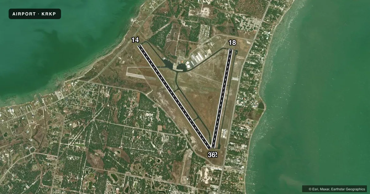
Airport sketch
Runways drawn to scale from FAA survey coordinates, rendered over satellite imagery. Not for navigation.
Approaches & charts
Services on the field
Fuel grades, oxygen, maintenance, ramp storage and lighting — as declared to the FAA by the airport operator.
Fuel & services
- Fuel
- 100LLA+
- Airframe repair
- Major
- Power plant repair
- Major
- Other services
- INSTR,RNTL
Ramp & ground
- Transient storage
- Tie-down
- Hangar
- Landing fee
- No fee published
- Customs
- Not available
- Lighting schedule
- SEE RMK
- Beacon schedule
- SS-SR
- Beacon
- White / Green (civil land)(WG)
- Wind indicator
- Lighted
- Segmented circle
- Yes
Fuel & FBOs
Cheapest 100LL and Jet A on the field and nearby. Always confirm with the FBO before taxi.
Airport notes
Surface conditions, obstructions, local procedures, lighting outages and other notes published with each FAA cycle.
General notes
- CREW CARS AVAILABLE FIRST COME OR RESERVATION.
- CREW REST FACILITY INCLUDING SLEEP ROOMS AND SHOWERS AVAILABLE WITH PRIOR COORDINATION W/ARPT.
Lighting notes
- MIRL RWY 14/32 & 18/36 PRESET LOW INTST. TO INCR INTST & ACTVT REIL 14 - CTAF.
Approach & departure obstructions
- 32APCH SLOPE 50:1 FM DSPLCD THR.
VFR map & nearby airports
VFR sectional. Tap any ICAO chip to open that airport.
Key facts · KRKP
Answer card- ICAO
- KRKP
- Name
- ARANSAS COUNTY
- Location
- ROCKPORT, TEXAS
- Elevation
- 23.8 ft MSL
- Traffic pattern altitude
- 1,023.8 ft MSL (1,000 AGL)
- Control tower
- Non-towered (use CTAF)
- Total runways
- 2
- Longest runway
- 14/32 · 5,608 ft
- Published ILS approaches
- 0
- Published frequencies
- 5
- Magnetic variation
- 6°
- Current flight rules
- VFR
- Current wind
- 150° at 11 kt
- Favored runway now
- RWY 14
Aransas County Airport sits in Rockport, Texas. Field elevation is 23.8 ft MSL. The airport has two asphalt runways. The longest is runway 14/32 at 5,608 ft. Runway 18/36 is 4,498 ft. There is no control tower. Pattern altitude is not published, so verify the current traffic pattern in the FAA Chart Supplement before you go. No ILS approaches are published here.
For local flying, the airport uses CTAF 123.05. The published frequencies also show Corpus approach and departure on 120.9 and 348.725. The on-field FBO is Aransas County Airport. It carries 100LL and Jet A with Prist phone support at (361) 790-0141. Crew cars are available on a first-come or reservation basis. Crew rest facilities, including sleep rooms and showers, are available with prior coordination with the airport.
A few operational notes matter here. Runway lighting on 14/32 and 18/36 is preset to low intensity. Use the CTAF to increase intensity and to activate runway end identifier lights on runway 14. The approach slope to runway 32 is 50 to 1 from the displaced threshold, so pay attention to your descent path. Rockport is a coastal field with light elevation. Expect to plan for local winds and standard sea-level performance, then confirm current conditions before departure.