METAR & TAF KARM
Current METAR
Observed 08:55Z
KARM 270855Z AUTO 00000KT 10SM CLR 24/24 A2998 RMK AO2 T02420237 TSNO
- Wind
- 000° @ 0 kt
- Visibility
- 10 SM
- Temp / Dew
- 24°C / 24°C
- Altimeter
- 29.98 inHg
- Clouds
- CLR
- Density alt
- 1,130 ft
- Ceiling
- Unlimited
- Rules
- VFR
Airport info & contacts
Manager on record, flight service, ARTCC, attendance schedule and pattern altitude — published by the FAA and refreshed every 28 days.
Location
- From city
- 5 NM SW
- VFR sectional
- HOUSTON
- ARTCC
- ZHU · HOUSTON
- NOTAM facility
- ARM (NOTAM-D)
Airport manager
- Name
- DWAYNE POSPISIL
- Phone
- 979-532-3210
- Address
- 714 ROBERT VONDERAU DR., WHARTON TX 77488
Flight service · Hours
- FSS CXO
- MONTGOMERY COUNTY1-800-WX-BRIEF
- Attendance
- MON-FRI · 0800-1700
Frequencies
Tap any row to copy the frequency to your clipboard.
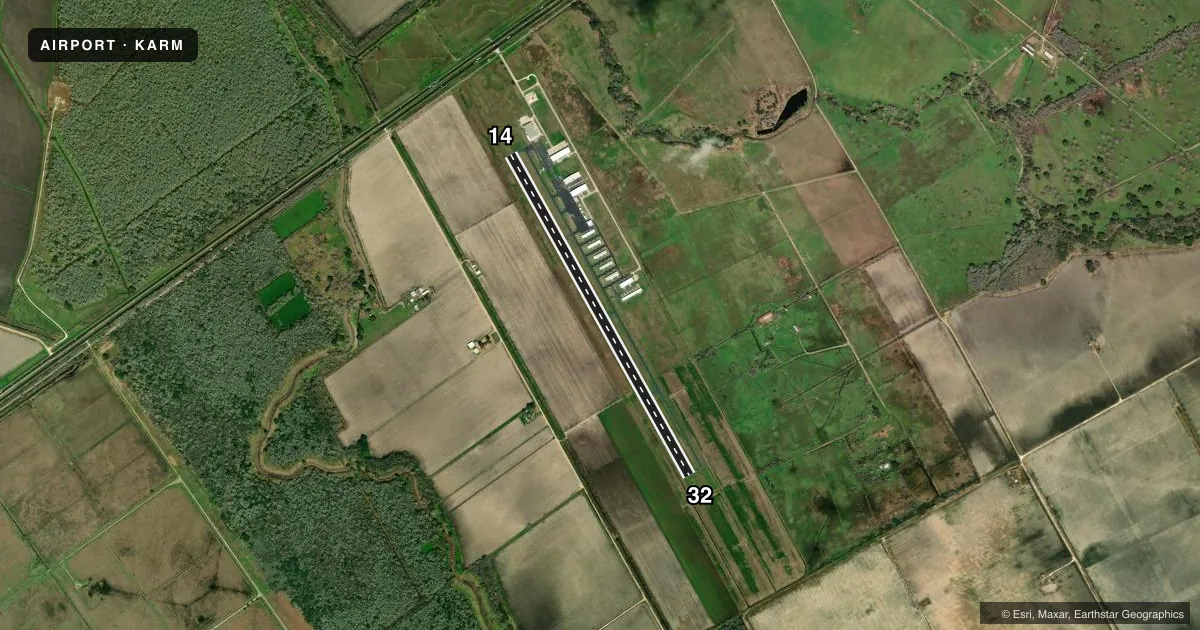
Runways & pattern
Full pagePattern entry · RWY 14
RIGHT TRAFFICRunway end performance
| End | TORA | TODA | ASDA | LDA | VGSI | Approach lights | Obstruction |
|---|---|---|---|---|---|---|---|
| 14 | — | — | — | — | PAPI 4-box left(3°) | — | 32', rr, 1252' from thr, 335' R of cntrln, slope 32 |
| 32 | — | — | — | — | PAPI 4-box left(3°) | — | — |
Declared distances in feet. TORA = takeoff run available, TODA = takeoff distance, ASDA = accelerate-stop, LDA = landing distance.
Airport sketch
Runways drawn to scale from FAA survey coordinates, rendered over satellite imagery. Not for navigation.
Approaches & charts
Services on the field
Fuel grades, oxygen, maintenance, ramp storage and lighting — as declared to the FAA by the airport operator.
Fuel & services
- Fuel
- 100LLA+
- Airframe repair
- Major
- Power plant repair
- Major
- Other services
- AGRI,INSTR
Ramp & ground
- Transient storage
- Tie-down
- Hangar
- Landing fee
- No fee published
- Customs
- Not available
- Lighting schedule
- SEE RMK
- Beacon schedule
- SS-SR
- Beacon
- White / Green (civil land)(WG)
- Wind indicator
- Lighted
- Segmented circle
- Yes
Fuel & FBOs
Cheapest 100LL and Jet A on the field and nearby. Always confirm with the FBO before taxi.
Airport notes
Surface conditions, obstructions, local procedures, lighting outages and other notes published with each FAA cycle.
General notes
- HANG GLDR ACTVT WI 5 NM OF ARPT UP TO 6000 FT AGL. HANG GLDR TOWING OPNS IN GRASSY AREA LEFT OF DER 14.
- FOR CD CTC HOUSTON ARTCC AT 281-230-5622.
- SVRL RWY/TWY LGTS OUT.
Lighting notes
- SS-SR, MIRL RWY 14/32 PRESET TO LOW INTENSITY; TO INCR INTST AND ACTVT - CTAF.
Fuel notes
- 100LL100 LL & JET A SELF SERVE. JET A ALSO BY TRUCK.
Other notes
- THIS AIRPORT HAS BEEN SURVEYED BY THE NATIONAL GEODETIC SURVEY.
- 1OTR TIMES ON REQ, CALL-IN FEE WAIVED WITH MIN FUEL PURCHASE.
- MANAGERARPT PHONE.
- OWNERCITY HALL PHONE.
- 14/32PAVEMENT CRACKING, SVRL AREAS WHERE PAVEMENT LIP EXCEEDS 3 INS.
VFR map & nearby airports
VFR sectional. Tap any ICAO chip to open that airport.
Key facts · KARM
Answer card- ICAO
- KARM
- Name
- WHARTON RGNL
- Location
- WHARTON, TEXAS
- Elevation
- 100 ft MSL
- Traffic pattern altitude
- 1,100 ft MSL (1,000 AGL)
- Control tower
- Non-towered (use CTAF)
- Total runways
- 1
- Longest runway
- 14/32 · 5,004 ft
- Published ILS approaches
- 0
- Published frequencies
- 2
- Magnetic variation
- 3°
- Current flight rules
- VFR
- Current wind
- 000° at 0 kt
- Favored runway now
- –
Wharton Rgnl is in Wharton, Texas. Field elevation is 100 ft MSL. The airport has one runway. Runway 14/32 is 5,004 ft long with asphalt pavement. There is no control tower. Pattern altitude is not published, so use the standard 1,000 ft AGL for light piston operations unless the current Chart Supplement says otherwise.
No ILS approaches are published here. CTAF and UNICOM are both 122.7. Wharton Regional Airport is the on-field FBO. It carries 100LL and Jet A. The fuel is self-serve. Jet A is also available by truck. Published remarks note that runway 14/32 has pavement cracking with several spots where the pavement lip exceeds 3 inches. Several runway and taxiway lights are also out. That makes a careful daylight inspection a good idea before you commit to the runway.
The field also has hang glider activity within 5 NM up to 6,000 ft AGL. Towing operations take place in the grassy area left of the departure end of runway 14. From sunset to sunrise, the runway lights on 14/32 come up at low intensity by default. Use the CTAF to increase intensity and activate them. For clearance delivery, contact Houston ARTCC at 281-230-5622. First-time visitors should plan for an uncontrolled field with mixed traffic. Lighting limitations are part of the picture. The runway surface deserves a close look.