METAR & TAF KVCT
Current METAR
Observed 04:51Z
KVCT 270451Z AUTO 17006KT 10SM CLR 26/24 A3000 RMK AO2 SLP156 T02560239
- Wind
- 170° @ 6 kt
- Visibility
- 10 SM
- Temp / Dew
- 26°C / 24°C
- Altimeter
- 30.00 inHg
- Clouds
- CLR
- Density alt
- 1,364 ft
- Ceiling
- Unlimited
- Rules
- VFR
Airport info & contacts
Manager on record, flight service, ARTCC, attendance schedule and pattern altitude — published by the FAA and refreshed every 28 days.
Location
- From city
- 5 NM NE
- VFR sectional
- HOUSTON
- ARTCC
- ZHU · HOUSTON
- NOTAM facility
- VCT (NOTAM-D)
Airport manager
- Name
- V. LENNY LLERENA
- Phone
- 361-578-2704
- Address
- 609 FOSTER FIELD DR SUITE F, VICTORIA TX 77904
Flight service · Hours
- FSS CXO
- MONTGOMERY COUNTY1-800-WX-BRIEF
- Attendance
- MON-FRI · 0600-2100
Frequencies
Tap any row to copy the frequency to your clipboard.
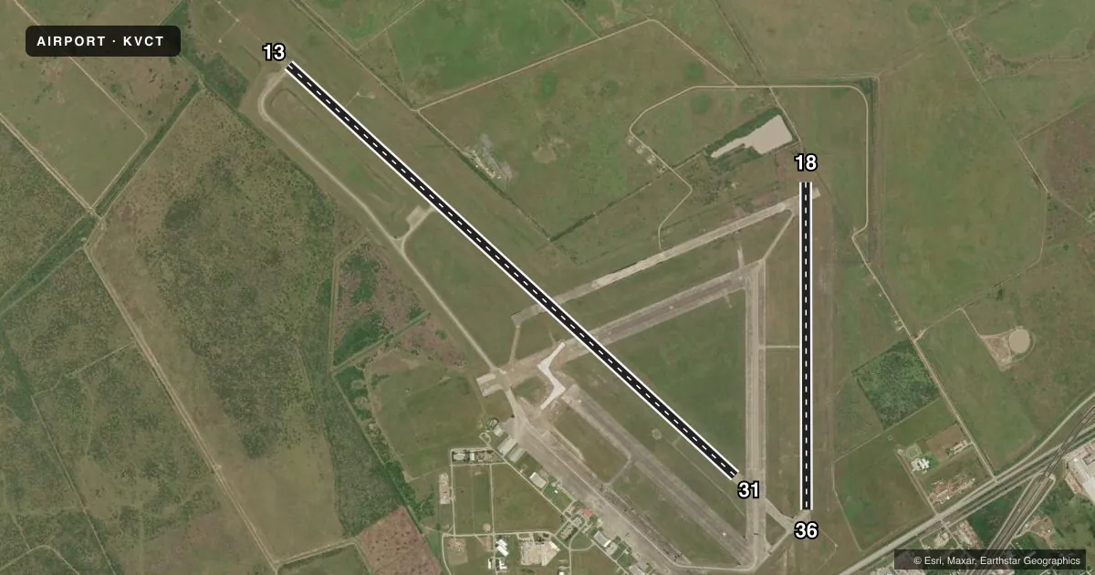
Runways & pattern
Full pagePattern entry · RWY 18
LEFT TRAFFIC| Runway | Heading (°M) | Length | Surface | Traffic |
|---|---|---|---|---|
| 13/31 | 128° / 308° | 9,111 ft | ASPH | 31 R |
| 18/36Favored | 176° / 356° | 4,908 ft | ASPH | Standard L |
Runway end performance
| End | TORA | TODA | ASDA | LDA | VGSI | Approach lights | Obstruction |
|---|---|---|---|---|---|---|---|
| 13 | 9,111' | 9,111' | 9,111' | 9,111' | — | MALSR | — |
| 31 | 9,111' | 9,111' | 9,111' | 9,111' | PAPI 4-box left(3°) | — | — |
| 18 | 4,908' | 4,908' | 4,908' | 4,908' | PAPI 2-box left(3°) | — | 6', fence, 400' from thr, 0' R of cntrln, slope 33 |
| 36 | 4,908' | 4,908' | 4,908' | 4,908' | PAPI 2-box left(3°) | — | 29', pole, 1544' from thr, 44' R of cntrln, slope 46 |
Declared distances in feet. TORA = takeoff run available, TODA = takeoff distance, ASDA = accelerate-stop, LDA = landing distance.
Airport sketch
Runways drawn to scale from FAA survey coordinates, rendered over satellite imagery. Not for navigation.
Approaches & charts
ILS · 1
Services on the field
Fuel grades, oxygen, maintenance, ramp storage and lighting — as declared to the FAA by the airport operator.
Fuel & services
- Fuel
- 100LLA
- Contract fuel
- Available
- Airframe repair
- Minor
- Power plant repair
- Minor
- Other services
- AFRT,INSTR
Ramp & ground
- Transient storage
- Tie-down
- Hangar
- Landing fee
- No fee published
- Customs
- Not available
- Lighting schedule
- SEE RMK
- Beacon schedule
- SS-SR
- Beacon
- White / Green (civil land)(WG)
- Wind indicator
- Lighted
- Segmented circle
- Yes
Fuel & FBOs
Cheapest 100LL and Jet A on the field and nearby. Always confirm with the FBO before taxi.
Airport notes
Surface conditions, obstructions, local procedures, lighting outages and other notes published with each FAA cycle.
General notes
- FOR CD IF UNA TO CTC ON FSS FREQ, CTC HOUSTON ARTCC AT 281-230-5622.
- AD AP BIRD ACT
Lighting notes
- HIRL RWY 13/31 PRESET LOW INTST, TO INCR INTST & ACTVT MALSR RWY 13 - CTAF. MIRL RWY 18/36 PRESET MED INTST ONLY. PAPI RWYS 31, 18 & 36 OPR CONSLY.
Runway surface & condition
- 13/31PCR VALUE: 610/F/D/X/T
- 18/36PCR VALUE: 130/R/A/W/T
Approach & departure obstructions
- 18REIL OTS INDEFLY.
- 36REIL OTS INDEFLY.
Other notes
- BETWEEN 2200-0700 ALL UNSCHEDULED ACR OPNS WITH MORE THAN 9 PSGR SEATS CONTACT ARFF 361-582-5889.
- TPA FOR JETS 1600 FT; FOR TURBO PROP, LIGHT AIRCRAFT, ROTORCRAFT 1100 FT AGL
VFR map & nearby airports
VFR sectional. Tap any ICAO chip to open that airport.
Key facts · KVCT
Answer card- ICAO
- KVCT
- Name
- VICTORIA RGNL
- Location
- VICTORIA, TEXAS
- Elevation
- 115.1 ft MSL
- Traffic pattern altitude
- 1,115.1 ft MSL (1,000 AGL)
- Control tower
- Towered · 0700-2200
- Total runways
- 2
- Longest runway
- 13/31 · 9,111 ft
- Published ILS approaches
- 1
- Published frequencies
- 7
- Magnetic variation
- 4°
- Current flight rules
- VFR
- Current wind
- 170° at 6 kt
- Favored runway now
- RWY 18
Victoria Rgnl sits in Victoria, Texas. The field elevation is 115.1 ft MSL. It has two asphalt runways. The longest is runway 13/31 at 9,111 ft. The airport is towered. The tower operates 0700-2200.
Runway 13 has the ILS approach. Published pattern altitude is not listed in the facts block. For light piston traffic, use 1,000 ft AGL as the standard pattern unless the current Chart Supplement says otherwise. The published remarks also note bird activity on the field. That is worth keeping in mind on arrival and departure.
Victoria Jet Center is on the field. It carries 100LL and Jet A. Call them at (361) 578-1221 for current ramp or fuel availability. Runway lighting is worth a look before you go. Runway 18 end identifier lights are out of service. Runway 36 end identifier lights are also out of service. Runway 13/31 lights are preset low. Use CTAF if you need to raise intensity on runway 13. The airport also publishes a jet pattern altitude of 1,600 ft MSL. Turbo prop, light aircraft and rotorcraft use 1,100 ft AGL.
For night or unscheduled operations with more than nine passenger seats between 2200 and 0700, contact ARFF before arrival. If you need clearance delivery and cannot reach flight service, Houston ARTCC is the listed backup contact.