METAR & TAF KPSX
Current METAR
Observed 19:53Z
KPSX 251953Z AUTO 14010KT 10SM CLR 32/23 A3007 RMK AO2 SLP183 T03220228 $
- Wind
- 140° @ 10 kt
- Visibility
- 10 SM
- Temp / Dew
- 32°C / 23°C
- Altimeter
- 30.07 inHg
- Clouds
- CLR
- Density alt
- 1,871 ft
- Ceiling
- Unlimited
- Rules
- VFR
Airport info & contacts
Manager on record, flight service, ARTCC, attendance schedule and pattern altitude — published by the FAA and refreshed every 28 days.
Location
- From city
- 3 NM NW
- VFR sectional
- HOUSTON
- ARTCC
- ZHU · HOUSTON
- NOTAM facility
- PSX (NOTAM-D)
Airport manager
- Name
- MANUEL GUEVARA
- Phone
- 361-404-9909
- Address
- PO BOX 845, PALACIOS TX 77465
Flight service · Hours
- FSS CXO
- MONTGOMERY COUNTY1-800-WX-BRIEF
- Attendance
- Unattended
Frequencies
Tap any row to copy the frequency to your clipboard.
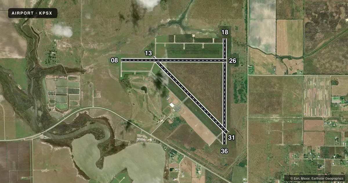
Runways & pattern
Full pagePattern entry · RWY 13
LEFT TRAFFIC| Runway | Heading (°M) | Length | Surface | Traffic |
|---|---|---|---|---|
| 08/26 | 87° / 267° | 5,001 ft | CONC | Standard L |
| 13/31Favored | 132° / 312° | 5,001 ft | CONC | Standard L |
| 18/36 | 177° / 357° | 5,001 ft | CONC | Standard L |
Runway end performance
| End | TORA | TODA | ASDA | LDA | VGSI | Approach lights | Obstruction |
|---|---|---|---|---|---|---|---|
| 08 | — | — | — | — | — | — | 18', trees, 418' from thr, 70' R of cntrln, slope 12 |
| 26 | — | — | — | — | — | — | 28', tower, 688' from thr, 290' R of cntrln, slope 17 |
| 31 | — | — | — | — | — | — | 15', tree, 463' from thr, 300' R of cntrln, slope 17 |
Declared distances in feet. TORA = takeoff run available, TODA = takeoff distance, ASDA = accelerate-stop, LDA = landing distance.
Airport sketch
Runways drawn to scale from FAA survey coordinates, rendered over satellite imagery. Not for navigation.
Approaches & charts
Services on the field
Fuel grades, oxygen, maintenance, ramp storage and lighting — as declared to the FAA by the airport operator.
Fuel & services
- Fuel
- Not available
Ramp & ground
- Transient storage
- Tie-down
- Landing fee
- No fee published
- Customs
- Not available
- Lighting schedule
- SEE RMK
- Beacon schedule
- SS-SR
- Beacon
- White / Green (civil land)(WG)
- Wind indicator
- Lighted
- Segmented circle
- Yes
Fuel & FBOs
Cheapest 100LL and Jet A on the field and nearby. Always confirm with the FBO before taxi.
Airport notes
Surface conditions, obstructions, local procedures, lighting outages and other notes published with each FAA cycle.
General notes
- VEGETATION ON TWY.
- COURTESY CAR AVBL.
- FOR CD IF UNA TO CTC ON FSS FREQ, CTC HOUSTON ARTCC AT 281-230-5622.
- TWYS, RWYS 8/26, 18/36 UNMKD.
Lighting notes
- MIRL RWY 13/31 PRESET ON LOW INTST; TO INCR INTST ACTVT - CTAF.
Approach & departure obstructions
- 08WINDMILL.
Other notes
- THIS AIRPORT HAS BEEN SURVEYED BY THE NATIONAL GEODETIC SURVEY.
- MANAGERMANUEL GUEVARA
- 08/26TALL VEGETATION ON RWY.
- 18/36TALL VEGETATION ON RWY.
VFR map & nearby airports
VFR sectional. Tap any ICAO chip to open that airport.
Key facts · KPSX
Answer card- ICAO
- KPSX
- Name
- PALACIOS MUNI
- Location
- PALACIOS, TEXAS
- Elevation
- 14.1 ft MSL
- Traffic pattern altitude
- 1,014.1 ft MSL (1,000 AGL)
- Control tower
- Non-towered (use CTAF)
- Total runways
- 3
- Longest runway
- 08/26 · 5,001 ft
- Published ILS approaches
- 0
- Published frequencies
- 2
- Magnetic variation
- 3°
- Current flight rules
- VFR
- Current wind
- 140° at 10 kt
- Favored runway now
- RWY 13
Palacios Muni sits in Palacios, Texas. Field elevation is 14.1 ft MSL. The airport has three runways. The longest is 5,001 ft. It is an untowered field. CTAF and UNICOM are both 122.8. No ILS approaches are published.
Pattern altitude is not published. Use the standard 1,000 ft AGL pattern for light piston operations unless the current Chart Supplement says otherwise. The field has one on-field FBO. Palacios Municipal Airport carries AVGAS 100LL. Call (361) 972-0783 before arrival if you need current service details.
A few runway notes matter here. Runway 13/31 has medium intensity lights that start on low. Use the CTAF to increase intensity. Runways 08/26 and 18/36 are unmarked. The Chart Supplement also notes tall vegetation near 08/26 and 18/36. There is a windmill near runway 08. Taxiways and runways 8/26 and 18/36 are unmarked. The airport manager is Manuel Guevara. A courtesy car is available. For clearance delivery issues, the published remark points pilots to Houston ARTCC. At this low field elevation, density altitude is usually not the main issue. The bigger concern is staying alert for the vegetation. The unmarked surfaces and the lack of tower support matter too.