METAR & TAF T85
T85 does not publish a METAR.
Showing the nearest reporting station: KVCT (VICTORIA RGNL) · 29.9 NM away. Conditions at T85 may differ.
METAR · KVCT
Observed 09:51Z
KVCT 270951Z AUTO 17003KT 8SM CLR 24/24 A2998 RMK AO2 SLP148 T02440239
- Wind
- 170° @ 3 kt
- Visibility
- 8 SM
- Temp / Dew
- 24°C / 24°C
- Altimeter
- 29.98 inHg
- Clouds
- CLR
- Density alt
- 1,459 ft
- Ceiling
- Unlimited
- Rules
- VFR
Airport info & contacts
Manager on record, flight service, ARTCC, attendance schedule and pattern altitude — published by the FAA and refreshed every 28 days.
Location
- From city
- 1 NM N
- VFR sectional
- SAN ANTONIO
- ARTCC
- ZHU · HOUSTON
- NOTAM facility
- CXO (NOTAM-D)
Airport manager
- Name
- MICHAEL MITCHELL
- Phone
- 361-293-6321
- Address
- PO BOX 738, YOAKUM TX 77995-0738
Flight service · Hours
- FSS CXO
- MONTGOMERY COUNTY1-800-WX-BRIEF
- Attendance
- Unattended
Frequencies
Tap any row to copy the frequency to your clipboard.
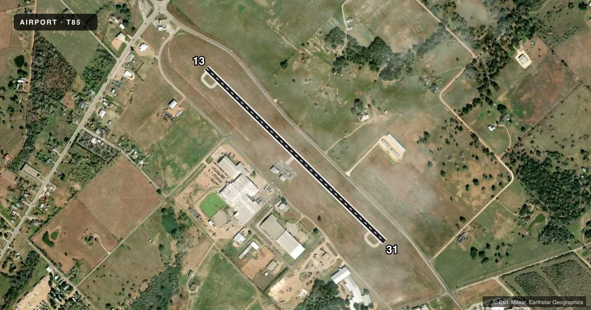
Runways & pattern
Full pagePattern entry · RWY 13
LEFT TRAFFICRunway end performance
| End | TORA | TODA | ASDA | LDA | VGSI | Approach lights | Obstruction |
|---|---|---|---|---|---|---|---|
| 13 | — | — | — | — | — | — | 45', pole, 998' from thr, 240' R of cntrln, slope 17 |
| 31 | — | — | — | — | — | — | 42', pole, 1230' from thr, 170' R of cntrln, slope 24 |
Declared distances in feet. TORA = takeoff run available, TODA = takeoff distance, ASDA = accelerate-stop, LDA = landing distance.
Airport sketch
Runways drawn to scale from FAA survey coordinates, rendered over satellite imagery. Not for navigation.
Approaches & charts
Services on the field
Fuel grades, oxygen, maintenance, ramp storage and lighting — as declared to the FAA by the airport operator.
Fuel & services
- Fuel
- Not available
Ramp & ground
- Transient storage
- Tie-down
- Landing fee
- No fee published
- Customs
- Not available
- Lighting schedule
- SS-SR
- Beacon schedule
- SS-SR
- Beacon
- White / Green (civil land)(WG)
- Wind indicator
- Lighted
- Segmented circle
- Yes
Fuel & FBOs
Cheapest 100LL and Jet A on the field and nearby. Always confirm with the FBO before taxi.
Airport notes
Surface conditions, obstructions, local procedures, lighting outages and other notes published with each FAA cycle.
General notes
- FOR CD CTC HOUSTON ARTCC AT 281-230-5622.
VFR map & nearby airports
VFR sectional. Tap any ICAO chip to open that airport.
Key facts · T85
Answer card- ICAO
- T85
- Name
- YOAKUM MUNI
- Location
- YOAKUM, TEXAS
- Elevation
- 365.4 ft MSL
- Traffic pattern altitude
- 1,365.4 ft MSL (1,000 AGL)
- Control tower
- Non-towered (use CTAF)
- Total runways
- 1
- Longest runway
- 13/31 · 3,444 ft
- Published ILS approaches
- 0
- Published frequencies
- 1
- Magnetic variation
- 6°
- Current flight rules
- VFR
- Current wind
- 170° at 3 kt
- Favored runway now
- RWY 13
Yoakum Muni (T85) sits in Yoakum, Texas. Field elevation is 365.4 ft MSL. The airport has one runway. Runway 13/31 is 3,444 ft long with asphalt pavement. The runway headings are 134° and 314° magnetic. There is no control tower. CTAF is 122.9.
No ILS approaches are published here. Pattern altitude is not published in the Chart Supplement. Use the standard 1,000 ft AGL pattern for light piston traffic unless local procedures say otherwise. The field is a simple non-towered stop, so self-announce early and keep your scan tight in the pattern. Runway markings are reported faded on both runway ends. That matters on short final and during taxi. For clearance delivery, Houston ARTCC is listed as the contact point at 281-230-5622.
No on-field FBOs are listed in the facts. Contact the airport operator directly or call the field on CTAF for current fuel and service availability before you go.