METAR & TAF E13
E13 does not publish a METAR.
Showing the nearest reporting station: KODO (ODESSA-SCHLEMEYER FLD) · 30.6 NM away. Conditions at E13 may differ.
METAR · KODO
Observed 17:53Z
KODO 271753Z AUTO 14010KT 10SM CLR 34/16 A3001 RMK AO2 SLP104 T03390161 10339 20239 58004 $
- Wind
- 140° @ 10 kt
- Visibility
- 10 SM
- Temp / Dew
- 34°C / 16°C
- Altimeter
- 30.01 inHg
- Clouds
- CLR
- Density alt
- 5,336 ft
- Ceiling
- Unlimited
- Rules
- VFR
Airport info & contacts
Manager on record, flight service, ARTCC, attendance schedule and pattern altitude — published by the FAA and refreshed every 28 days.
Location
- From city
- 1 NM NW
- VFR sectional
- SAN ANTONIO
- ARTCC
- ZFW · FORT WORTH
- NOTAM facility
- SJT (NOTAM-D)
Airport manager
- Name
- TODD SEABOURN
- Phone
- 432-631-5196
- Address
- COUNTY COURTHOUSE, 201 W 6TH ST., CRANE TX 79731
Flight service · Hours
- FSS SJT
- SAN ANGELO1-800-WX-BRIEF
- Attendance
- Unattended
Frequencies
Tap any row to copy the frequency to your clipboard.
Runways & pattern
Full pagePattern entry · RWY 12
LEFT TRAFFICRunway end performance
| End | TORA | TODA | ASDA | LDA | VGSI | Approach lights | Obstruction |
|---|---|---|---|---|---|---|---|
| 12 | — | — | — | — | PAPI 2-box left(3.5°) | — | — |
| 30 | — | — | — | — | PAPI 2-box left(3°) | — | 34', pole, 415' from thr, 57' R of cntrln, slope 6 |
Declared distances in feet. TORA = takeoff run available, TODA = takeoff distance, ASDA = accelerate-stop, LDA = landing distance.
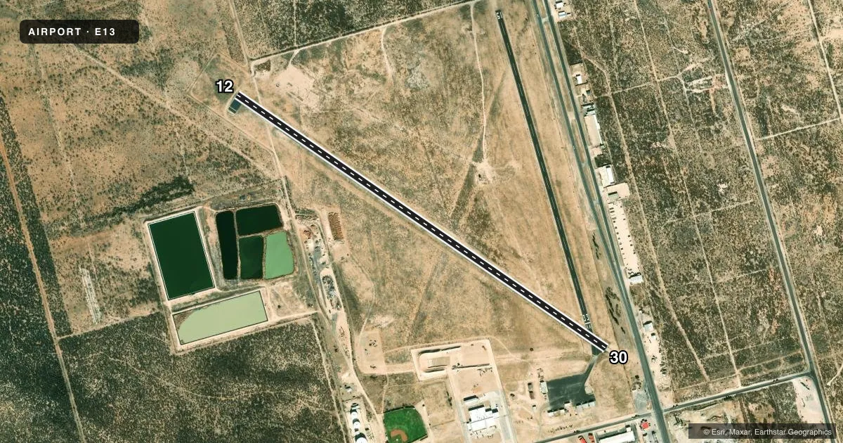
Airport sketch
Runways drawn to scale from FAA survey coordinates, rendered over satellite imagery. Not for navigation.
Approaches & charts
Services on the field
Fuel grades, oxygen, maintenance, ramp storage and lighting — as declared to the FAA by the airport operator.
Fuel & services
- Fuel
- Not available
Ramp & ground
- Transient storage
- Tie-down
- Landing fee
- No fee published
- Customs
- Not available
- Lighting schedule
- SEE RMK
- Beacon schedule
- SS-SR
- Beacon
- White / Green (civil land)(WG)
- Wind indicator
- Lighted
- Segmented circle
- Yes
Fuel & FBOs
Cheapest 100LL and Jet A on the field and nearby. Always confirm with the FBO before taxi.
Airport notes
Surface conditions, obstructions, local procedures, lighting outages and other notes published with each FAA cycle.
General notes
- FOR CD CTC FORT WORTH ARTCC AT 817-858-7584.
- RWY 15, 75 FT PWRLINE CROSSES APCH PATH 1800 FT DSTC.
- RWY 33, 126 FT UNLIGHTED TEMPORARY CRANES OCCASIONALLY IN APCH.
Lighting notes
- PAPI RWY 12 & 30; MIRL RWY 12/30 - CTAF.
Approach & departure obstructions
- 1510 FT RD, 135 FT DSTC, 125 FT L/R. 15 FT TREES 156 FT DSTC, 125 FT L/R.
- 304 FT FENCE, 0-199 FT DSTC, 28 FT L-135 FT R.
- 1530 FT PLINE ACROSS APCH.
- 30APCH RATIO 20:1 TO DSPLCD THR OVR 75 FT BLDG, 1458 FT DSTC, 195 FT R.
- 33APCH SLOPE 26:1 TO DSPLCD THR; TEMPORARILY 15:1 OVR 126 FT UNLGTD OIL RIG.
Other notes
- MANAGERPARKS DEPT/AMGR.
VFR map & nearby airports
VFR sectional. Tap any ICAO chip to open that airport.
Key facts · E13
Answer card- ICAO
- E13
- Name
- CRANE COUNTY
- Location
- CRANE, TEXAS
- Elevation
- 2,554.7 ft MSL
- Traffic pattern altitude
- 3,554.7 ft MSL (1,000 AGL)
- Control tower
- Non-towered (use CTAF)
- Total runways
- 1
- Longest runway
- 12/30 · 4,258 ft
- Published ILS approaches
- 0
- Published frequencies
- 1
- Magnetic variation
- 9°
- Current flight rules
- VFR
- Current wind
- 140° at 10 kt
- Favored runway now
- RWY 12
Crane County Airport (E13) sits in Crane, Texas. The field elevation is 2,554.7 ft MSL. It has one runway, 12/30, which is 4,258 ft long and asphalt. There is no control tower. CTAF is 122.9. No ILS approaches are published here.
Pattern altitude is not published. Use the standard 1,000 ft AGL pattern unless local traffic or current guidance says otherwise. The runway lighting on 12 and 30 is medium intensity and is controlled by CTAF. PAPI is available on both ends. The published remarks also flag several approach hazards. There are roads, trees, a fence, powerlines and temporary cranes or an oil rig that can affect the approach path. Runway 30 also has a displaced threshold note with a building off to the right. Runway 15 has a powerline crossing the approach path. This is a field where a current preflight review matters.
There are no on-field FBOs listed in the facts. Contact the airport operator directly or call the field on CTAF for current services. The airport manager is the Parks Department manager. For clearance delivery, contact Fort Worth ARTCC at 817-858-7584. A first-time pilot should plan for the elevation. Watch the obstacle notes closely. Verify runway condition and lighting status before arrival.