METAR & TAF E01
Current METAR
Observed 22:35Z
KE01 272235Z AUTO 09010KT 10SM CLR 39/14 A2985 RMK AO2 TSNO
- Wind
- 090° @ 10 kt
- Visibility
- 10 SM
- Temp / Dew
- 39°C / 14°C
- Altimeter
- 29.85 inHg
- Clouds
- CLR
- Density alt
- 6,209 ft
- Ceiling
- Unlimited
- Rules
- VFR
Airport info & contacts
Manager on record, flight service, ARTCC, attendance schedule and pattern altitude — published by the FAA and refreshed every 28 days.
Location
- From city
- 1 NM SW
- VFR sectional
- SAN ANTONIO
- ARTCC
- ZFW · FORT WORTH
- NOTAM facility
- SJT (NOTAM-D)
Airport manager
- Name
- JOHN CUTBIRTH
- Phone
- 432-940-2633
- Address
- P.O.BOX 1610, MONAHANS TX 79756
Flight service · Hours
- FSS SJT
- SAN ANGELO1-800-WX-BRIEF
- Attendance
- 0700-1700
Frequencies
Tap any row to copy the frequency to your clipboard.
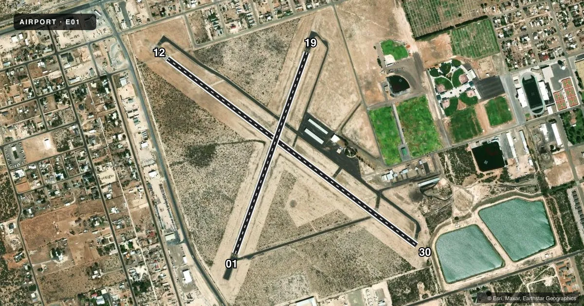
Runways & pattern
Full pagePattern entry · RWY 12
LEFT TRAFFIC| Runway | Heading (°M) | Length | Surface | Traffic |
|---|---|---|---|---|
| 12/30Favored | 118° / 298° | 4,268 ft | ASPH | Standard L |
| 01/19 | 11° / 191° | 2,922 ft | ASPH | Standard L |
Runway end performance
| End | TORA | TODA | ASDA | LDA | VGSI | Approach lights | Obstruction |
|---|---|---|---|---|---|---|---|
| 12 | — | — | — | — | PAPI 2-box left(3°) | — | 25', pole, 495' from thr, 22' R of cntrln, slope 11 |
| 30 | — | — | — | — | — | — | 46', tree, 1035' from thr, 36' R of cntrln, slope 18 |
| 01 | — | — | — | — | — | — | 25', tank, 1190' from thr, 60' R of cntrln, slope 39 |
| 19 | — | — | — | — | — | — | 38', tree, 595' from thr, 200' R of cntrln, slope 10 |
Declared distances in feet. TORA = takeoff run available, TODA = takeoff distance, ASDA = accelerate-stop, LDA = landing distance.
Airport sketch
Runways drawn to scale from FAA survey coordinates, rendered over satellite imagery. Not for navigation.
Approaches & charts
Services on the field
Fuel grades, oxygen, maintenance, ramp storage and lighting — as declared to the FAA by the airport operator.
Fuel & services
- Fuel
- 100LLA
- Oxygen (bottled)
- Not available
- Oxygen (bulk)
- Not available
- Airframe repair
- Minor
- Power plant repair
- Minor
- Other services
- INSTR
Ramp & ground
- Transient storage
- Tie-down
- Landing fee
- No fee published
- Customs
- Not available
- Lighting schedule
- SEE RMK
- Beacon schedule
- SS-SR
- Beacon
- White / Green (civil land)(WG)
- Wind indicator
- Lighted
- Segmented circle
- Yes
Fuel & FBOs
Cheapest 100LL and Jet A on the field and nearby. Always confirm with the FBO before taxi.
Airport notes
Surface conditions, obstructions, local procedures, lighting outages and other notes published with each FAA cycle.
General notes
- DOWN SLOPE OFF END OF RWY 30.
- WILDLIFE & BIRDS ON & INVOF ARPT.
- FOR CD CTC FORT WORTH ARTCC AT 817-858-7584.
- RWY 19 APCH, 325 FT AGL 2953 MSL ANT, 1.45 NM NE OF ARPT.
- NMRS RWY LGTS OUT.
- HOLD LINE SIGNS FADED WHITE, RWY NRS NOT VSB.
Lighting notes
- ACTVT PAPI RWY 12; MIRL RWY 01/19 & 12/30 - CTAF.
Approach & departure obstructions
- 12APCH SLOPE 23:1 TO DSPLCD THR OVR 60 FT MKD/LTG PLINE, 1425 FT DSTC, 135 FT R.
Other notes
- THIS AIRPORT HAS BEEN SURVEYED BY THE NATIONAL GEODETIC SURVEY.
- 01/19NMRS LRG CRACKS.
VFR map & nearby airports
VFR sectional. Tap any ICAO chip to open that airport.
Key facts · E01
Answer card- ICAO
- E01
- Name
- ROY HURD MEML
- Location
- MONAHANS, TEXAS
- Elevation
- 2,614.5 ft MSL
- Traffic pattern altitude
- 3,614.5 ft MSL (1,000 AGL)
- Control tower
- Non-towered (use CTAF)
- Total runways
- 2
- Longest runway
- 12/30 · 4,268 ft
- Published ILS approaches
- 0
- Published frequencies
- 2
- Magnetic variation
- 9°
- Current flight rules
- VFR
- Current wind
- 090° at 10 kt
- Favored runway now
- RWY 12
Roy Hurd Meml sits in Monahans, Texas. The field elevation is 2,614.5 ft MSL. It has two asphalt runways. The longest is 4,268 ft on runway 12/30. There is no control tower. CTAF and UNICOM are both 122.8. No ILS approaches are published.
Pattern altitude is not published. Use the standard 1,000 ft AGL for light piston traffic unless the current Chart Supplement says otherwise. Monahans Air Center is on the field. It carries 100LL and Jet A Prist. Call (432) 940-7484 for current service details.
The published remarks matter here. Runway 30 has a downslope off the end. Runway 12 has a displaced threshold with a marked and lighted power line on the approach path. The field also has wildlife and birds in the area. Several runway lights are reported out. Runway 01/19 has numerous large cracks. The runway 19 approach also has an antenna northeast of the airport. This is a non-towered field with a long runway, but the surface and lighting notes deserve a close preflight. Check the current FAA Chart Supplement for any updated operational notes before you go.