METAR & TAF KPEQ
Current METAR
Observed 11:35Z
KPEQ 271135Z AUTO 08005KT 10SM CLR 25/15 A2994 RMK AO2 T02460146 PWINO
- Wind
- 080° @ 5 kt
- Visibility
- 10 SM
- Temp / Dew
- 25°C / 15°C
- Altimeter
- 29.94 inHg
- Clouds
- CLR
- Density alt
- 4,415 ft
- Ceiling
- Unlimited
- Rules
- VFR
Airport info & contacts
Manager on record, flight service, ARTCC, attendance schedule and pattern altitude — published by the FAA and refreshed every 28 days.
Location
- From city
- 2 NM SW
- VFR sectional
- EL PASO
- ARTCC
- ZAB · ALBUQUERQUE
- NOTAM facility
- PEQ (NOTAM-D)
Airport manager
- Name
- COLEY MEANS
- Phone
- 512-422-6396
- Address
- 3110 MANAHAN STREET, PECOS TX 79772
Flight service · Hours
- FSS SJT
- SAN ANGELO1-800-WX-BRIEF
- Attendance
- ALL
Frequencies
Tap any row to copy the frequency to your clipboard.
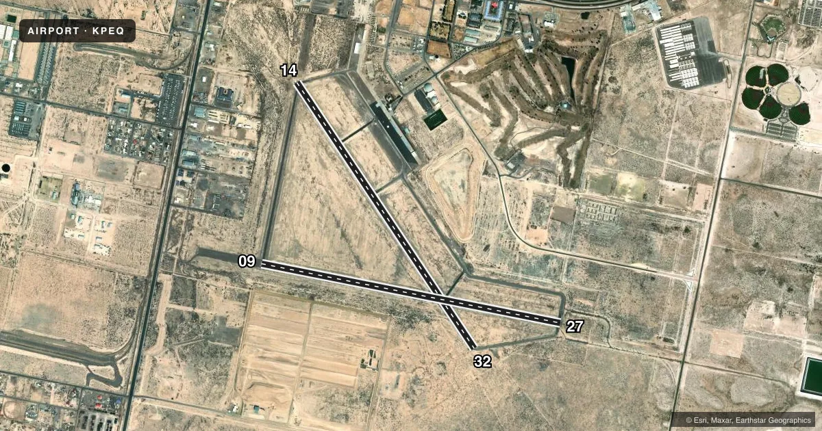
Runways & pattern
Full pagePattern entry · RWY 09
LEFT TRAFFIC| Runway | Heading (°M) | Length | Surface | Traffic |
|---|---|---|---|---|
| 14/32 | 137° / 317° | 6,236 ft | ASPH | Standard L |
| 09/27Favored | 92° / 272° | 5,953 ft | ASPH | Standard L |
Runway end performance
| End | TORA | TODA | ASDA | LDA | VGSI | Approach lights | Obstruction |
|---|---|---|---|---|---|---|---|
| 14 | — | — | — | — | PAPI 2-box left(3°) | — | 75', sign, 2514' from thr, 395' R of cntrln, slope 30 |
| 32 | — | — | — | — | PAPI 2-box left(3°) | — | — |
| 27 | — | — | — | — | — | — | 45', pline, 2020' from thr, 0' R of cntrln, slope 40 |
Declared distances in feet. TORA = takeoff run available, TODA = takeoff distance, ASDA = accelerate-stop, LDA = landing distance.
Airport sketch
Runways drawn to scale from FAA survey coordinates, rendered over satellite imagery. Not for navigation.
Approaches & charts
Services on the field
Fuel grades, oxygen, maintenance, ramp storage and lighting — as declared to the FAA by the airport operator.
Fuel & services
- Fuel
- 100LLA1+
- Oxygen (bottled)
- Not available
- Oxygen (bulk)
- Not available
- Airframe repair
- Major
- Power plant repair
- Major
Ramp & ground
- Transient storage
- Tie-down
- Hangar
- Landing fee
- No fee published
- Customs
- Not available
- Lighting schedule
- SEE RMK
- Beacon schedule
- SS-SR
- Beacon
- White / Green (civil land)(WG)
- Wind indicator
- Lighted
- Segmented circle
- Yes
Fuel & FBOs
Cheapest 100LL and Jet A on the field and nearby. Always confirm with the FBO before taxi.
Airport notes
Surface conditions, obstructions, local procedures, lighting outages and other notes published with each FAA cycle.
General notes
- FOR CD IF UNA TO CTC ON FSS FREQ, CTC ALBUQUERQUE ARTCC AT 505-856-4561.
Lighting notes
- MIRL RY 14/32 PRESET LOW INTST; TO INCR INTST & ACTVT MIRL RY 09/27 - CTAF. PAPI RYS 14 & 32 OPERATES CONTINUOUSLY.
Fuel notes
- 100LLFOR FUEL AFTER HOURS CTC UNICOM 122.8 OR CALL 432-447-2488.
Runway surface & condition
- 14/32MIRLS NSTD 20 FT FROM PVMNT EDGE.
Approach & departure obstructions
- 14PAPI OTS
Other notes
- THIS AIRPORT HAS BEEN SURVEYED BY THE NATIONAL GEODETIC SURVEY.
VFR map & nearby airports
VFR sectional. Tap any ICAO chip to open that airport.
Key facts · KPEQ
Answer card- ICAO
- KPEQ
- Name
- PECOS MUNI
- Location
- PECOS, TEXAS
- Elevation
- 2,613.1 ft MSL
- Traffic pattern altitude
- 3,613.1 ft MSL (1,000 AGL)
- Control tower
- Non-towered (use CTAF)
- Total runways
- 2
- Longest runway
- 14/32 · 6,236 ft
- Published ILS approaches
- 0
- Published frequencies
- 2
- Magnetic variation
- 9°
- Current flight rules
- VFR
- Current wind
- 080° at 5 kt
- Favored runway now
- RWY 09
Pecos Muni sits in Pecos, Texas. The field elevation is 2,613.1 ft MSL. It has two asphalt runways. The longest is runway 14/32 at 6,236 ft. This is an unattended field with no control tower. CTAF and UNICOM are both 122.8.
No ILS approaches are published here. The pattern altitude is not published, so plan on the standard 1,000 ft AGL for light piston traffic unless the current Chart Supplement says otherwise. That puts the pattern at about 3,613 ft MSL based on the field elevation, but verify the published pattern before you go. Runway 14 has a PAPI that is out of service. The PAPI on 14 and 32 is listed as operating continuously. Medium intensity runway lights on 14/32 are preset to low intensity. Use CTAF to increase intensity. Use CTAF to activate the medium intensity lights on 09/27.
Crosby Flying Services is on the field. It carries 100LL and Jet A Prist. For 100LL after hours, contact UNICOM on 122.8 or call the FBO directly. The airport also notes that clearance delivery may be handled through Albuquerque ARTCC if flight service cannot be reached. Expect West Texas density altitude to matter here, especially in warm weather. Check the current FAA Chart Supplement for any noise or operational notes before departure.