METAR & TAF E38
Current METAR
Observed 11:35Z
KE38 271135Z AUTO 24008KT 10SM CLR 22/13 A3015 RMK AO2 T02220125
- Wind
- 240° @ 8 kt
- Visibility
- 10 SM
- Temp / Dew
- 22°C / 13°C
- Altimeter
- 30.15 inHg
- Clouds
- CLR
- Density alt
- 6,153 ft
- Ceiling
- Unlimited
- Rules
- VFR
Airport info & contacts
Manager on record, flight service, ARTCC, attendance schedule and pattern altitude — published by the FAA and refreshed every 28 days.
Location
- From city
- 2 NM NW
- VFR sectional
- EL PASO
- ARTCC
- ZAB · ALBUQUERQUE
- NOTAM facility
- E38 (NOTAM-D)
Airport manager
- Name
- MEGAN ANTRIM
- Phone
- 432-837-5929
- Address
- 100 N. 13TH STREET, ALPINE TX 79830
Flight service · Hours
- FSS SJT
- SAN ANGELO1-800-WX-BRIEF
- Attendance
- MON-FRI · 0800-1700
- SAT · 0800-1600
Frequencies
Tap any row to copy the frequency to your clipboard.
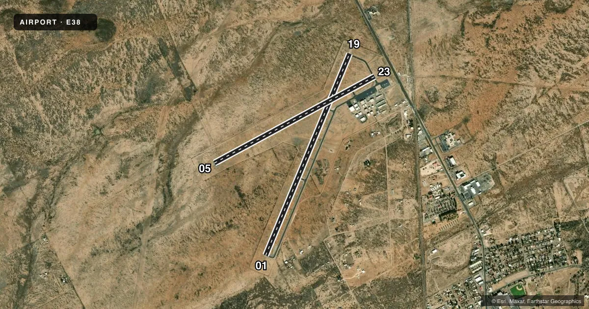
Runways & pattern
Full pagePattern entry · RWY 23
LEFT TRAFFIC| Runway | Heading (°M) | Length | Surface | Traffic |
|---|---|---|---|---|
| 01/19 | 14° / 194° | 6,002 ft | ASPH | Standard L |
| 05/23Favored | 53° / 233° | 5,018 ft | ASPH | Standard L |
Runway end performance
| End | TORA | TODA | ASDA | LDA | VGSI | Approach lights | Obstruction |
|---|---|---|---|---|---|---|---|
| 01 | — | — | — | — | PAPI 2-box left(3.5°) | — | 30', pline, 1340' from thr, 0' R of cntrln, slope 38 |
| 19 | — | — | — | — | PAPI 2-box left(3°) | — | 4', fence, 295' from thr, 0' R of cntrln, slope 23 |
| 05 | — | — | — | — | — | — | 10', fence, 500' from thr, 0' R of cntrln, slope 30 |
| 23 | — | — | — | — | — | — | 15', road, 537' from thr, 0' R of cntrln, slope 22 |
Declared distances in feet. TORA = takeoff run available, TODA = takeoff distance, ASDA = accelerate-stop, LDA = landing distance.
Airport sketch
Runways drawn to scale from FAA survey coordinates, rendered over satellite imagery. Not for navigation.
Approaches & charts
Services on the field
Fuel grades, oxygen, maintenance, ramp storage and lighting — as declared to the FAA by the airport operator.
Fuel & services
- Fuel
- 100LLAA1+
- Oxygen (bottled)
- Not available
- Oxygen (bulk)
- Not available
- Airframe repair
- Major
- Power plant repair
- Major
- Other services
- AMB,CHTR,INSTR,SALES
Ramp & ground
- Transient storage
- Not published
- Landing fee
- No fee published
- Customs
- Not available
- Lighting schedule
- SEE RMK
- Beacon schedule
- SS-SR
- Beacon
- White / Green (civil land)(WG)
- Wind indicator
- Lighted
- Segmented circle
- Yes
Fuel & FBOs
Cheapest 100LL and Jet A on the field and nearby. Always confirm with the FBO before taxi.
Airport notes
Surface conditions, obstructions, local procedures, lighting outages and other notes published with each FAA cycle.
General notes
- FOR CD CTC ALBUQUERQUE ARTCC AT 505-856-4861.
- SELF SVC FUEL AVBL 24 HRS.
Lighting notes
- MIRL RWY 01/19 PRESET LOW INTST; TO INCR INTST AND TO ACTVT MIRL RWY 05/23 - CTAF.
Approach & departure obstructions
- 01PAPI RWY 01 DOES NOT PRVD OBSTN CLNC BYD 2.0 NM FM THR.
Other notes
- 1UNATNDD SUN & MAJ HOL. AFT HRS CALL-IN FEE.
- MANAGERCITY/AMGR.
VFR map & nearby airports
VFR sectional. Tap any ICAO chip to open that airport.
Key facts · E38
Answer card- ICAO
- E38
- Name
- ALPINE-CASPARIS MUNI
- Location
- ALPINE, TEXAS
- Elevation
- 4,514.4 ft MSL
- Traffic pattern altitude
- 5,514.4 ft MSL (1,000 AGL)
- Control tower
- Non-towered (use CTAF)
- Total runways
- 2
- Longest runway
- 01/19 · 6,002 ft
- Published ILS approaches
- 0
- Published frequencies
- 2
- Magnetic variation
- 9°
- Current flight rules
- VFR
- Current wind
- 240° at 8 kt
- Favored runway now
- RWY 23
Alpine-Casparis Muni sits in Alpine, Texas at 4,514.4 ft MSL. It has two asphalt runways. The longest is runway 01/19 at 6,002 ft. Runway 05/23 is 5,018 ft. This is a non-towered field. CTAF and UNICOM are both 122.8. No ILS approaches are published here.
Pattern altitude is not published. Use the standard 1,000 ft AGL for light piston traffic unless local procedures or the current chart supplement say otherwise. The field is high enough that performance planning matters, especially on warm days. Expect higher density altitude than you would at lower-elevation airports.
The on-field FBO is Alpine-Casparis Municipal Airport. It carries 100LL and Jet A. Self-serve fuel is available 24 hours. The airport can be unattended on Sundays and major holidays. After hours there is a call-in fee, so plan ahead if you expect a late arrival.
A few operational notes matter here. Runway 01/19 has medium intensity lights preset to low intensity. Use the CTAF to increase intensity. The PAPI for runway 01 does not provide obstruction clearance beyond 2.0 NM from the threshold. For clearance delivery, contact Albuquerque ARTCC at 505-856-4861. If you are new to the field, brief the high elevation. Brief the runway lighting setup. Brief the lack of published ILS before you go.