METAR & TAF 1E2
1E2 does not publish a METAR.
Showing the nearest reporting station: KPRS (PRESIDIO LELY INTL) · 51.5 NM away. Conditions at 1E2 may differ.
METAR · KPRS
Observed 10:35Z
KPRS 071035Z AUTO 01006KT 10SM CLR 25/16 A3007 RMK AO2 T02520160
- Wind
- 010° @ 6 kt
- Visibility
- 10 SM
- Temp / Dew
- 25°C / 16°C
- Altimeter
- 30.07 inHg
- Clouds
- CLR
- Density alt
- 5,688 ft
- Ceiling
- Unlimited
- Rules
- VFR
Airport info & contacts
Manager on record, flight service, ARTCC, attendance schedule and pattern altitude — published by the FAA and refreshed every 28 days.
Location
- From city
- 57 NM SE
- VFR sectional
- EL PASO
- ARTCC
- ZAB · ALBUQUERQUE
- NOTAM facility
- SJT (NOTAM-D)
Airport manager
- Name
- JOHN SELLERS
- Phone
- 432-371-3146
- Address
- BOX 638, TERLINGUA TX 79852
Flight service · Hours
- FSS SJT
- SAN ANGELO1-800-WX-BRIEF
- Attendance
- Unattended
Frequencies
Tap any row to copy the frequency to your clipboard.
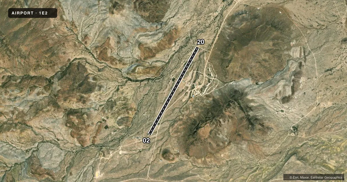
Runways & pattern
Full pagePattern entry · RWY 02
LEFT TRAFFICRunway end performance
| End | TORA | TODA | ASDA | LDA | VGSI | Approach lights | Obstruction |
|---|---|---|---|---|---|---|---|
| 02 | — | — | — | — | — | — | 12', trees, 0' from thr, 0' R of cntrln, slope 0 |
| 20 | — | — | — | — | — | — | 12', road, 10' from thr, 0' R of cntrln, slope 0 |
Declared distances in feet. TORA = takeoff run available, TODA = takeoff distance, ASDA = accelerate-stop, LDA = landing distance.
Airport sketch
Runways drawn to scale from FAA survey coordinates, rendered over satellite imagery. Not for navigation.
Approaches & charts
Services on the field
Fuel grades, oxygen, maintenance, ramp storage and lighting — as declared to the FAA by the airport operator.
Fuel & services
- Fuel
- Not available
- Oxygen (bottled)
- Not available
- Oxygen (bulk)
- Not available
- Airframe repair
- Not available
- Power plant repair
- Not available
Ramp & ground
- Transient storage
- Tie-down
- Hangar
- Landing fee
- No fee published
- Wind indicator
- Yes
- Segmented circle
- Yes
Fuel & FBOs
Cheapest 100LL and Jet A on the field and nearby. Always confirm with the FBO before taxi.
Airport notes
Surface conditions, obstructions, local procedures, lighting outages and other notes published with each FAA cycle.
General notes
- ARPT SRNDD BY 2000 FT MTNS.
- WILDLIFE ON & INVOF ARPT.
- FOR CD CTC ALBUQUERQUE ARTCC AT 505-856-4861.
- 5-15 FT BRUSH AT RWY EDGE. FULL RWY WID MAY NOT BE AVBL.
Runway surface & condition
- 02/20RWY SLOPES UP FM NE TO SW 128 FT (2.7%).
Other notes
- OWNERPROPERTY OWNERS ASSOCIATION OF TERLINGUA RANCH INC
- MANAGEREXT 14
- 02/20RWY ROUGH & UNEVEN GRAVEL.
VFR map & nearby airports
VFR sectional. Tap any ICAO chip to open that airport.
Key facts · 1E2
Answer card- ICAO
- 1E2
- Name
- TERLINGUA RANCH
- Location
- ALPINE, TEXAS
- Elevation
- 3,769 ft MSL
- Traffic pattern altitude
- 4,769 ft MSL (1,000 AGL)
- Control tower
- Non-towered (use CTAF)
- Total runways
- 1
- Longest runway
- 02/20 · 4,700 ft
- Published ILS approaches
- 0
- Published frequencies
- 1
- Magnetic variation
- 9°
- Current flight rules
- VFR
- Current wind
- 010° at 6 kt
- Favored runway now
- RWY 02
Terlingua Ranch Airport (1E2) sits near Alpine, Texas. Field elevation is 3,769 ft MSL. The airport has one runway. Runway 02/20 is 4,700 ft long. It is gravel-dirt. There is no control tower. CTAF is 122.9. No ILS approaches are published.
Pattern altitude is not published. Use the standard 1,000 ft AGL for light piston aircraft unless the current Chart Supplement says otherwise. That puts the pattern at 4,769 ft MSL. The field sits in high terrain. The airport is surrounded by 2,000 ft mountains. Wildlife is reported on and near the airport. Five to fifteen foot brush is at the runway edge. Full runway width may not be available. The runway surface is rough and uneven gravel. Runway 02/20 slopes up from the northeast to the southwest.
No on-field FBOs are listed. Plan on self-sufficiency and verify current services with the airport operator before you go. For clearance delivery, contact Albuquerque ARTCC at 505-856-4861. If you are new to this strip, give yourself extra margin on performance. Give yourself extra margin on density altitude. Give yourself extra margin on runway condition. Check the current Chart Supplement before departure for any updated remarks or operational changes.