METAR & TAF 6R6
Current METAR
Observed 14:51Z
K6R6 271451Z AUTO 13007KT 29/19 A3000 RMK AO1 SLP117 T02940189 51006
- Wind
- 130° @ 7 kt
- Visibility
- —
- Temp / Dew
- 29°C / 19°C
- Altimeter
- 30.00 inHg
- Clouds
- Clear
- Density alt
- 4,462 ft
- Ceiling
- Unlimited
- Rules
- VFR
Airport info & contacts
Manager on record, flight service, ARTCC, attendance schedule and pattern altitude — published by the FAA and refreshed every 28 days.
Location
- From city
- 5 NM W
- VFR sectional
- SAN ANTONIO
- ARTCC
- ZHU · HOUSTON
- NOTAM facility
- SJT (NOTAM-D)
Airport manager
- Name
- C D CURRY
- Phone
- 432-345-6731
- Address
- PO BOX 350, SANDERSON TX 79848
Flight service · Hours
- FSS SJT
- SAN ANGELO1-800-WX-BRIEF
- Attendance
- INTMNT
Frequencies
Tap any row to copy the frequency to your clipboard.
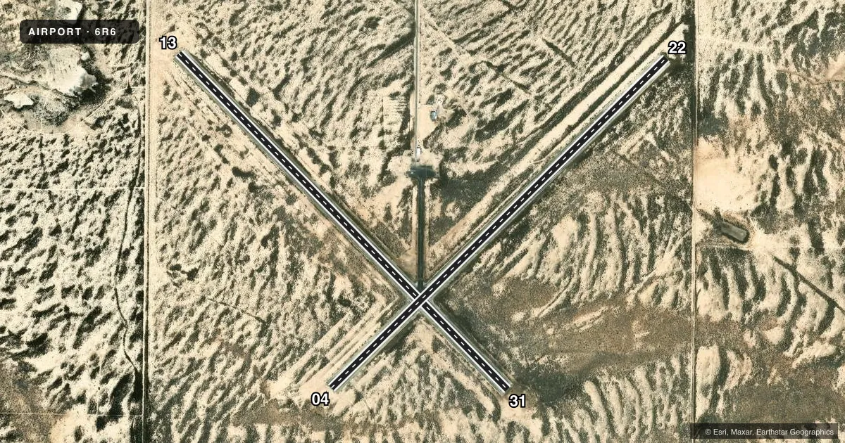
Runways & pattern
Full pagePattern entry · RWY 13
LEFT TRAFFIC| Runway | Heading (°M) | Length | Surface | Traffic |
|---|---|---|---|---|
| 13/31Favored | 127° / 307° | 4,526 ft | ASPH | Standard L |
| 04/22 | 37° / 217° | 4,525 ft | ASPH | Standard L |
Runway end performance
| End | TORA | TODA | ASDA | LDA | VGSI | Approach lights | Obstruction |
|---|---|---|---|---|---|---|---|
| 13 | — | — | — | — | — | — | 8', fence, 278' from thr, 130' R of cntrln, slope 9 |
| 22 | — | — | — | — | — | — | 5', brush, 266' from thr, 125' R of cntrln, slope 13 |
Declared distances in feet. TORA = takeoff run available, TODA = takeoff distance, ASDA = accelerate-stop, LDA = landing distance.
Airport sketch
Runways drawn to scale from FAA survey coordinates, rendered over satellite imagery. Not for navigation.
Approaches & charts
Services on the field
Fuel grades, oxygen, maintenance, ramp storage and lighting — as declared to the FAA by the airport operator.
Fuel & services
- Fuel
- Not available
- Airframe repair
- Not available
- Power plant repair
- Not available
Ramp & ground
- Transient storage
- Tie-down
- Landing fee
- No fee published
- Customs
- Not available
- Lighting schedule
- SEE RMK
- Beacon schedule
- SS-SR
- Beacon
- White / Green (civil land)(WG)
- Wind indicator
- Lighted
- Segmented circle
- Yes
Fuel & FBOs
Cheapest 100LL and Jet A on the field and nearby. Always confirm with the FBO before taxi.
Airport notes
Surface conditions, obstructions, local procedures, lighting outages and other notes published with each FAA cycle.
General notes
- FOR CD CTC HOUSTON ARTCC AT 281-230-5622.
- RWY 04/22 AND RWY 13/31 EXTSV CRACKING, LOOSE STONES ON SFC.
- RWY 13/31 AND RWY 04/22 MRKG POOR DUE TO PAVEMENT DETERIORATION.
Lighting notes
- ACTVT MIRL RWY 13/31 - CTAF. HELI PAD LGTS, 5 CLICKS - 123.05.
Approach & departure obstructions
- 2210 FT BRUSH, 15 FT DSTC, 20 FT R.
VFR map & nearby airports
VFR sectional. Tap any ICAO chip to open that airport.
Key facts · 6R6
Answer card- ICAO
- 6R6
- Name
- TERRELL COUNTY
- Location
- DRYDEN, TEXAS
- Elevation
- 2,323.4 ft MSL
- Traffic pattern altitude
- 3,323.4 ft MSL (1,000 AGL)
- Control tower
- Non-towered (use CTAF)
- Total runways
- 2
- Longest runway
- 13/31 · 4,526 ft
- Published ILS approaches
- 0
- Published frequencies
- 1
- Magnetic variation
- 9°
- Current flight rules
- VFR
- Current wind
- 130° at 7 kt
- Favored runway now
- RWY 13
Terrell County Airport (6R6) sits near Dryden, Texas. The field elevation is 2,323.4 ft MSL. It has two asphalt runways. The longest is runway 13/31 at 4,526 ft. This is an untowered field, so plan to self-announce on CTAF 122.9 and keep a close ear on traffic. No ILS approaches are published here.
Pattern altitude is not published. Use the standard 1,000 ft AGL pattern for light piston operations unless the current FAA Chart Supplement says otherwise. At this elevation, density altitude can get your attention on warm days. That matters with two runways that are both a little over 4,500 ft.
Published remarks say both runways have extensive cracking and loose stones. Markings are also poor because of pavement deterioration. Runway 22 has a 10-foot brush obstruction about 15 ft from the runway and 20 ft right of centerline. Medium intensity runway lights on 13/31 are activated by CTAF. Helicopter pad lights use 5 clicks on 123.05. For clearance delivery, contact Houston ARTCC at 281-230-5622. No on-field FBOs are listed, so contact the airport operator directly or call the field on CTAF for current service status before you go.