METAR & TAF KFST
Current METAR
Observed 22:53Z
KFST 272253Z AUTO 17008KT 10SM CLR 38/13 A2987 RMK AO2 SLP055 T03830128
- Wind
- 170° @ 8 kt
- Visibility
- 10 SM
- Temp / Dew
- 38°C / 13°C
- Altimeter
- 29.87 inHg
- Clouds
- CLR
- Density alt
- 6,556 ft
- Ceiling
- Unlimited
- Rules
- VFR
Airport info & contacts
Manager on record, flight service, ARTCC, attendance schedule and pattern altitude — published by the FAA and refreshed every 28 days.
Location
- From city
- 2 NM NW
- VFR sectional
- SAN ANTONIO
- ARTCC
- ZAB · ALBUQUERQUE
- NOTAM facility
- FST (NOTAM-D)
Airport manager
- Name
- TOM CHAPMAN
- Phone
- 432-336-6261
- Address
- PO BOX 1624, FORT STOCKTON TX 79735
Flight service · Hours
- FSS SJT
- SAN ANGELO1-800-WX-BRIEF
- Attendance
- 0800-1700
Frequencies
Tap any row to copy the frequency to your clipboard.
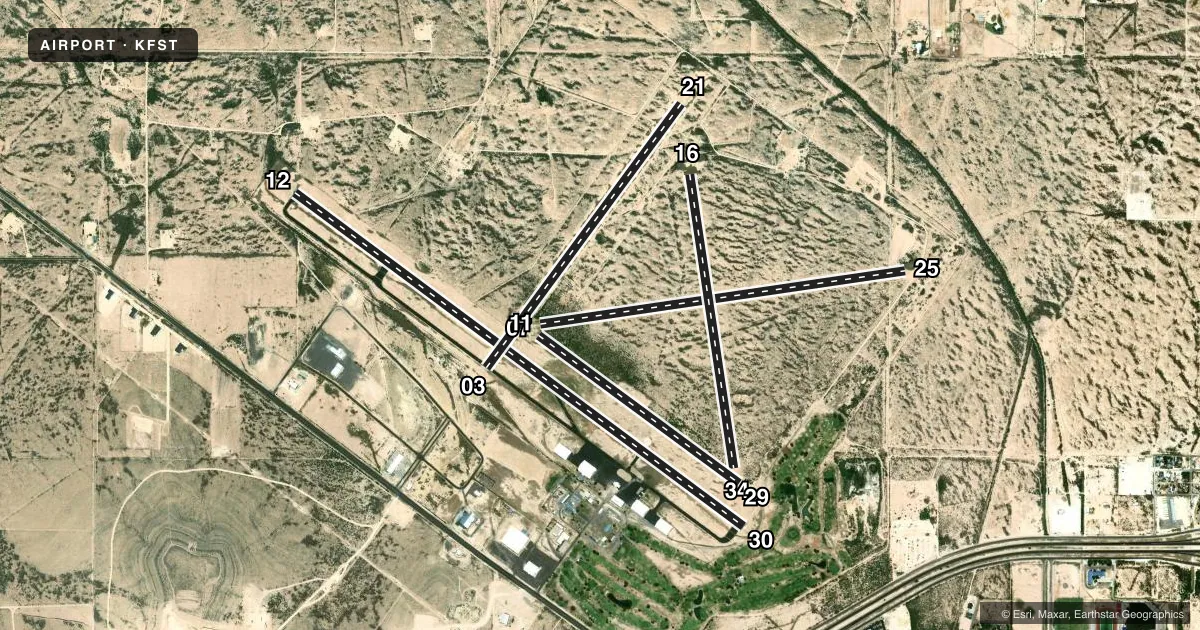
Runways & pattern
Full pagePattern entry · RWY 16
LEFT TRAFFIC| Runway | Heading (°M) | Length | Surface | Traffic |
|---|---|---|---|---|
| 12/30 | 118° / 298° | 7,508 ft | ASPH | Standard L |
| 07/25 | 73° / 253° | 4,961 ft | TURF | Standard L |
| 03/21 | 28° / 208° | 4,400 ft | ASPH | Standard L |
| 16/34Favored | 162° / 342° | 3,981 ft | TURF | Standard L |
| 11/29 | 117° / 297° | 3,348 ft | TURF | Standard L |
Runway end performance
| End | TORA | TODA | ASDA | LDA | VGSI | Approach lights | Obstruction |
|---|---|---|---|---|---|---|---|
| 12 | — | — | — | — | PAPI 4-box left(3°) | — | 20', tree, 500' from thr, 165' R of cntrln, slope 15 |
| 30 | — | — | — | — | PAPI 4-box left(3°) | — | 10', road, 200' from thr, 250' R of cntrln, slope 0 |
| 25 | — | — | — | — | — | — | 9', trees, 186' from thr, 23' R of cntrln, slope 20 |
| 03 | — | — | — | — | — | — | 110', pline, 2100' from thr, 195' R of cntrln, slope 17 |
| 16 | — | — | — | — | — | — | 10', brush, 0' from thr, 0' R of cntrln, slope 0 |
| 34 | — | — | — | — | — | — | 75', tree, 1400' from thr, 148' R of cntrln, slope 18 |
| 29 | — | — | — | — | — | — | 10', road, 65' from thr, 0' R of cntrln, slope 6 |
Declared distances in feet. TORA = takeoff run available, TODA = takeoff distance, ASDA = accelerate-stop, LDA = landing distance.
Airport sketch
Runways drawn to scale from FAA survey coordinates, rendered over satellite imagery. Not for navigation.
Approaches & charts
Services on the field
Fuel grades, oxygen, maintenance, ramp storage and lighting — as declared to the FAA by the airport operator.
Fuel & services
- Fuel
- 100LLA+
- Oxygen (bottled)
- Not available
- Other services
- AGRI,AMB
Ramp & ground
- Transient storage
- Tie-down
- Hangar
- Landing fee
- No fee published
- Customs
- Not available
- Lighting schedule
- SEE RMK
- Beacon schedule
- SS-SR
- Beacon
- White / Green (civil land)(WG)
- Wind indicator
- Lighted
- Segmented circle
- Yes
Fuel & FBOs
Cheapest 100LL and Jet A on the field and nearby. Always confirm with the FBO before taxi.
Airport notes
Surface conditions, obstructions, local procedures, lighting outages and other notes published with each FAA cycle.
General notes
- 3210 FT TWR 2 MI NE.
- FOR CD IF UNA TO CTC ON FSS FREQ, CTC ALBUQUERQUE ARTCC AT 505-856-4561.
- TURF RWY 7/25, 11/29,16/34 ROUGH. RWY ENDS 16 & 25 NOT INSPD DUE TO FLD CONDS.
Lighting notes
- MIRL RWYS 03/21 & 12/30 PRESET LOW INTST; TO INCR INTST - CTAF. PAPI RWYS 12 & 30 OPR CONSLY.
Fuel notes
- 100LLFOR FUEL & SVCS AFT HRS CALL 432-336-9900 OR UNICOM. 24 HR SELF SERVE AVBL.
Approach & departure obstructions
- 125 FT FENCE, 0-199 FT DSTC, 145 FT L.
- 30GRAVEL ROAD AT 190 FT ACRS APCH.
- 11THR NOT MKD.
- 29THR NOT MKD.
- 12UNUSBL BYD 8 DEG RIGHT OF RCL.
- 30UNUSBL BYD 8 DEG RIGHT OF RCL.
- 1610 FT TREES AND BRUSH AT THR ACRS APCH.
Other notes
- MANAGERCOUNTY COMMISSIONER.
- 11/29RWY NOT MKD - ROUGH WITH THORNS.
- 07/25RWY NOT MKD - ROUGH WITH THORNS.
- 16/34RWY NOT MKD - ROUGH WITH THORNS.
VFR map & nearby airports
VFR sectional. Tap any ICAO chip to open that airport.
Key facts · KFST
Answer card- ICAO
- KFST
- Name
- FORT STOCKTON-PECOS COUNTY
- Location
- FORT STOCKTON, TEXAS
- Elevation
- 3,011 ft MSL
- Traffic pattern altitude
- 4,011 ft MSL (1,000 AGL)
- Control tower
- Non-towered (use CTAF)
- Total runways
- 5
- Longest runway
- 12/30 · 7,508 ft
- Published ILS approaches
- 0
- Published frequencies
- 2
- Magnetic variation
- 9°
- Current flight rules
- VFR
- Current wind
- 170° at 8 kt
- Favored runway now
- RWY 16
Fort Stockton-Pecos County Airport sits in Fort Stockton, Texas. The field elevation is 3,011 ft MSL. It has five runways. The longest is runway 12/30 at 7,508 ft asphalt. This is a non-towered field. CTAF and UNICOM are both 122.8. No ILS approaches are published. Pattern altitude is not published, so plan on the standard 1,000 ft AGL for light piston unless the current FAA Chart Supplement says otherwise.
The airport has one on-field FBO. Fort Stockton Aviation is on the field. It carries 100LL and Jet A Prist. Twenty-four hour self-serve fuel is available. After hours, the published remarks say to call the FBO or use UNICOM for fuel and services.
The turf runways are rough. Runways 07/25, 11/29 and 16/34 are turf. The remarks also say runway 07/25 is not marked and has thorns. Runway 11/29 is not marked and has thorns. Runway 16 has trees and brush near the threshold on the approach side. Runway 12 has a fence close in on the left side near the threshold. Runway 30 is unusable beyond 8 degrees right of centerline. The medium-intensity lights on 03/21 and 12/30 start at low intensity. Use CTAF to increase them. The precision approach path indicators on 12 and 30 operate continuously. This is a high-elevation West Texas field. Expect density altitude to matter on warm days.