METAR & TAF KINK
Current METAR
Observed 18:53Z
KINK 271853Z AUTO 13009KT 37/16 A2994 RMK AO2 SLP085 T03720161 TSNO $
- Wind
- 130° @ 9 kt
- Visibility
- —
- Temp / Dew
- 37°C / 16°C
- Altimeter
- 29.94 inHg
- Clouds
- Clear
- Density alt
- 6,114 ft
- Ceiling
- Unlimited
- Rules
- VFR
Airport info & contacts
Manager on record, flight service, ARTCC, attendance schedule and pattern altitude — published by the FAA and refreshed every 28 days.
Location
- From city
- 3 NM NW
- VFR sectional
- EL PASO
- ARTCC
- ZFW · FORT WORTH
- NOTAM facility
- INK (NOTAM-D)
Airport manager
- Name
- CHARLES WOLF
- Phone
- 432-586-6658
- Address
- 100 E. WINKLER ST., KERMIT TX 79745
Flight service · Hours
- FSS SJT
- SAN ANGELO1-800-WX-BRIEF
- Attendance
- MON-SAT · 0800-1800
Frequencies
Tap any row to copy the frequency to your clipboard.
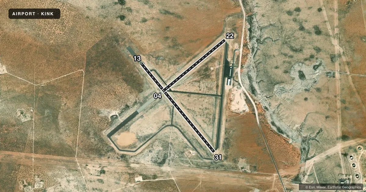
Runways & pattern
Full pagePattern entry · RWY 13
LEFT TRAFFIC| Runway | Heading (°M) | Length | Surface | Traffic |
|---|---|---|---|---|
| 13/31Favored | 132° / 312° | 5,003 ft | ASPH | Standard L |
| 04/22 | 42° / 222° | 3,514 ft | ASPH | Standard L |
Runway end performance
| End | TORA | TODA | ASDA | LDA | VGSI | Approach lights | Obstruction |
|---|---|---|---|---|---|---|---|
| 13 | — | — | — | — | PAPI 2-box left(3°) | — | 5', brush, 200' from thr, 244' R of cntrln, slope 0 |
| 31 | — | — | — | — | PAPI 2-box left(3°) | — | 8', brush, 200' from thr, 285' R of cntrln, slope 0 |
| 04 | — | — | — | — | — | — | 8', brush, 200' from thr, 39' R of cntrln, slope 0 |
| 22 | — | — | — | — | — | — | 23', pline, 900' from thr, 130' R of cntrln, slope 30 |
Declared distances in feet. TORA = takeoff run available, TODA = takeoff distance, ASDA = accelerate-stop, LDA = landing distance.
Airport sketch
Runways drawn to scale from FAA survey coordinates, rendered over satellite imagery. Not for navigation.
Approaches & charts
Services on the field
Fuel grades, oxygen, maintenance, ramp storage and lighting — as declared to the FAA by the airport operator.
Fuel & services
- Fuel
- 100LLA+
- Oxygen (bottled)
- Not available
- Oxygen (bulk)
- Not available
- Airframe repair
- Not available
- Power plant repair
- Not available
Ramp & ground
- Transient storage
- Tie-down
- Hangar
- Landing fee
- No fee published
- Customs
- Not available
- Lighting schedule
- SEE RMK
- Beacon schedule
- SS-SR
- Beacon
- White / Green (civil land)(WG)
- Wind indicator
- Lighted
- Segmented circle
- Yes
Fuel & FBOs
Cheapest 100LL and Jet A on the field and nearby. Always confirm with the FBO before taxi.
Airport notes
Surface conditions, obstructions, local procedures, lighting outages and other notes published with each FAA cycle.
General notes
- FOR CD IF UNA TO CTC ON FSS FREQ, CTC FORT WORTH ARTCC AT 817-858-7584.
Lighting notes
- MIRL RWYS 04/22 & 13/31 PRESET LOW INTST; TO INCR INTST - CTAF.
Fuel notes
- 100LLFUEL AVBL 24 HRS SELF SERVE OR FULL SVC.
Other notes
- THIS AIRPORT HAS BEEN SURVEYED BY THE NATIONAL GEODETIC SURVEY.
VFR map & nearby airports
VFR sectional. Tap any ICAO chip to open that airport.
Key facts · KINK
Answer card- ICAO
- KINK
- Name
- WINKLER COUNTY
- Location
- WINK, TEXAS
- Elevation
- 2,821.6 ft MSL
- Traffic pattern altitude
- 3,821.6 ft MSL (1,000 AGL)
- Control tower
- Non-towered (use CTAF)
- Total runways
- 2
- Longest runway
- 13/31 · 5,003 ft
- Published ILS approaches
- 0
- Published frequencies
- 2
- Magnetic variation
- 8°
- Current flight rules
- VFR
- Current wind
- 130° at 9 kt
- Favored runway now
- RWY 13
Winkler County Airport is in Wink, Texas. The field elevation is 2,821.6 ft MSL. It has two asphalt runways. The longest is 13/31 at 5,003 ft. There is no control tower. CTAF and UNICOM are both 123.0.
No ILS approaches are published here. Pattern altitude is not published, so use the standard 1,000 ft AGL for light piston operations unless the current Chart Supplement says otherwise. The airport has been surveyed by the National Geodetic Survey. Runway lights on 04/22 and 13/31 are preset to low intensity. Use CTAF to increase intensity.
The on-field FBO is Winkler County Airport. It carries JET_A_PRIST. Fuel is also listed as available 24 hours self-serve or full service. The airport sits in west Texas at a relatively high elevation, so density altitude will matter on warm days. For clearance delivery if you cannot reach Flight Service, contact Fort Worth ARTCC at 817-858-7584. Check the current Chart Supplement before departure for any published noise or operating notes.