METAR & TAF E26
E26 does not publish a METAR.
Showing the nearest reporting station: KINK (WINKLER COUNTY) · 21.2 NM away. Conditions at E26 may differ.
METAR · KINK
Observed 11:53Z
KINK 271153Z AUTO 13008KT CLR 24/15 A2995 RMK AO2 SLP093 T02440150 10289 20244 55006 TSNO $
- Wind
- 130° @ 8 kt
- Visibility
- —
- Temp / Dew
- 24°C / 15°C
- Altimeter
- 29.95 inHg
- Clouds
- CLR
- Density alt
- 4,909 ft
- Ceiling
- Unlimited
- Rules
- VFR
Airport info & contacts
Manager on record, flight service, ARTCC, attendance schedule and pattern altitude — published by the FAA and refreshed every 28 days.
Location
- From city
- 3 NM NE
- VFR sectional
- ALBUQUERQUE
- ARTCC
- ZFW · FORT WORTH
- NOTAM facility
- ABQ (NOTAM-D)
Airport manager
- Name
- CORY NEEDHAM
- Phone
- 575-391-2934
- Address
- PO BOX 1106, HOBBS NM 88241-1106
Flight service · Hours
- FSS ABQ
- ALBUQUERQUE1-800-WX-BRIEF
- Attendance
- Unattended
Frequencies
Tap any row to copy the frequency to your clipboard.
Runways & pattern
Full pagePattern entry · RWY 09
LEFT TRAFFIC| Runway | Heading (°M) | Length | Surface | Traffic |
|---|---|---|---|---|
| 01/19 | 11° / 191° | 4,704 ft | ASPH | Standard L |
| 09/27Favored | 95° / 275° | 2,604 ft | ASPH | Standard L |
Runway end performance
| End | TORA | TODA | ASDA | LDA | VGSI | Approach lights | Obstruction |
|---|---|---|---|---|---|---|---|
| 01 | — | — | — | — | PAPI 2-box left(3.03°) | — | — |
| 19 | — | — | — | — | PAPI 2-box left(2.83°) | — | 12', brush, 300' from thr, 10' R of cntrln, slope 8 |
| 09 | — | — | — | — | — | — | 4', brush, 201' from thr, 0' R of cntrln, slope 0 |
Declared distances in feet. TORA = takeoff run available, TODA = takeoff distance, ASDA = accelerate-stop, LDA = landing distance.
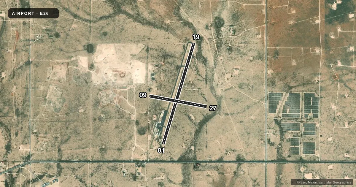
Airport sketch
Runways drawn to scale from FAA survey coordinates, rendered over satellite imagery. Not for navigation.
Approaches & charts
Services on the field
Fuel grades, oxygen, maintenance, ramp storage and lighting — as declared to the FAA by the airport operator.
Fuel & services
- Fuel
- Not available
Ramp & ground
- Transient storage
- Tie-down
- Landing fee
- No fee published
- Customs
- Not available
- Lighting schedule
- SEE RMK
- Beacon schedule
- SS-SR
- Beacon
- White / Green (civil land)(WG)
- Wind indicator
- Lighted
- Segmented circle
- Yes
Fuel & FBOs
Cheapest 100LL and Jet A on the field and nearby. Always confirm with the FBO before taxi.
Airport notes
Surface conditions, obstructions, local procedures, lighting outages and other notes published with each FAA cycle.
General notes
- LINE OF SIGHT BTN RWYS NA.
- OIL DRILLING ACT ON & INVOF ARPT.
- FOR CD CTC FORT WORTH ARTCC AT 817-858-7584.
Lighting notes
- ACTVT PAPI RWY 01 & 19; MIRL RWY 01/19 - CTAF. MIRL RWY 01/19 PRESET LOW INTST - INCR INTST - CTAF.
Runway surface & condition
- 09/273-5 FT BRUSH 60-125 FT FM CNTRLN NORTH SIDE.
Approach & departure obstructions
- 094 FT FENCE 50 FT FM THR; 10 FT ROAD 40 FT FM THR.
- 191 FT TO 2 FT BRUSH 0 FT - 200 FT FM THR, 95 FT LEFT OF CNTRLN.
- 274 FT FENCE 15 FT FM END, 8 FT BRUSH 20 FT FM RY END, 10 FT ROAD 0 FT FM THR.
- 013 FT POSTS 145 FT FM THR ON CNTRLN & 40 FT LEFT & 110 FT RIGHT OF CNTRLN.
- 1920 FT PUMP JACK 990 FT FM THR 185 FT LEFT OF CNTRLN.
- 09APCH SLOPE 4:1 TO DTHR DUE TO 10 FT ROAD 40 FT FM DTHR.
- 27APCH SLOPE 5:1 TO DTHR DUE TO 10 FT ROAD 65 FT FM DTHR.
VFR map & nearby airports
VFR sectional. Tap any ICAO chip to open that airport.
Key facts · E26
Answer card- ICAO
- E26
- Name
- LEA COUNTY/JAL
- Location
- JAL, NEW MEXICO
- Elevation
- 3,118 ft MSL
- Traffic pattern altitude
- 4,118 ft MSL (1,000 AGL)
- Control tower
- Non-towered (use CTAF)
- Total runways
- 2
- Longest runway
- 01/19 · 4,704 ft
- Published ILS approaches
- 0
- Published frequencies
- 1
- Magnetic variation
- 6°
- Current flight rules
- VFR
- Current wind
- 130° at 8 kt
- Favored runway now
- RWY 09
Lea County/JAL Airport (E26) sits in JAL, New Mexico. Field elevation is 3,118 ft MSL. The airport has two asphalt runways. The longest is runway 01/19 at 4,704 ft. There is no control tower. CTAF is 122.9. No ILS approaches are published here.
Pattern altitude is not published. Use 1,000 ft AGL for light piston operations unless the current FAA Chart Supplement says otherwise. That puts the traffic pattern at about 4,118 ft MSL based on the field elevation. Runway 01 and runway 19 have PAPI. Medium intensity runway lights on 01/19 are activated on CTAF.
There are no on-field FBOs listed, so call the airport operator or the field directly before arrival for fuel and services. Published remarks also note oil drilling activity on and near the airport. That is worth planning around on arrival and departure. Runway 09 has nearby road and fence obstructions. Runway 27 also has a road close to the threshold. Runway 19 has a pump jack near the approach path. Expect a non-towered environment with local traffic on CTAF. Keep a close scan for surface hazards near both runways.