METAR & TAF KPRS
Current METAR
Observed 10:35Z
KPRS 071035Z AUTO 01006KT 10SM CLR 25/16 A3007 RMK AO2 T02520160
- Wind
- 010° @ 6 kt
- Visibility
- 10 SM
- Temp / Dew
- 25°C / 16°C
- Altimeter
- 30.07 inHg
- Clouds
- CLR
- Density alt
- 4,658 ft
- Ceiling
- Unlimited
- Rules
- VFR
Airport info & contacts
Manager on record, flight service, ARTCC, attendance schedule and pattern altitude — published by the FAA and refreshed every 28 days.
Location
- From city
- 5 NM N
- VFR sectional
- EL PASO
- ARTCC
- ZAB · ALBUQUERQUE
- NOTAM facility
- PRS (NOTAM-D)
Airport manager
- Name
- CHASE SNODGRASS
- Phone
- 361-480-6933
- Address
- PO BOX 1338, SONORA TX 76950
Flight service · Hours
- FSS SJT
- SAN ANGELO1-800-WX-BRIEF
- Attendance
- MON-FRI · 0800-1600
Frequencies
Tap any row to copy the frequency to your clipboard.
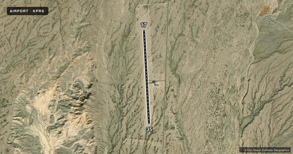
Runways & pattern
Full pagePattern entry · RWY 35
LEFT TRAFFICRunway end performance
| End | TORA | TODA | ASDA | LDA | VGSI | Approach lights | Obstruction |
|---|---|---|---|---|---|---|---|
| 17 | — | — | — | — | PSIL(3°) | — | — |
| 35 | — | — | — | — | PSIL(3°) | — | 17', tree, 355' from thr, 66' R of cntrln, slope 9 |
Declared distances in feet. TORA = takeoff run available, TODA = takeoff distance, ASDA = accelerate-stop, LDA = landing distance.
Airport sketch
Runways drawn to scale from FAA survey coordinates, rendered over satellite imagery. Not for navigation.
Approaches & charts
Services on the field
Fuel grades, oxygen, maintenance, ramp storage and lighting — as declared to the FAA by the airport operator.
Fuel & services
- Fuel
- 100LLA
- Airframe repair
- Minor
- Power plant repair
- Minor
- Other services
- INSTR,RNTL
Ramp & ground
- Transient storage
- Tie-down
- Landing fee
- No fee published
- Customs
- Not available
- Lighting schedule
- SEE RMK
- Beacon schedule
- SS-SR
- Beacon
- White / Green (civil land)(WG)
- Wind indicator
- Lighted
- Segmented circle
- Yes
Fuel & FBOs
Cheapest 100LL and Jet A on the field and nearby. Always confirm with the FBO before taxi.
Airport notes
Surface conditions, obstructions, local procedures, lighting outages and other notes published with each FAA cycle.
General notes
- FOR CD CTC ALBUQUERQUE ARTCC AT 505-856-4861.
Lighting notes
- MIRL RWY 17/35 PRESET LOW INTST; TO INCR INTST ACTVT - CTAF.
Fuel notes
- 100LL100LL, JET-A, SELF SERVE AVBL 24 HRS.
Approach & departure obstructions
- 17PVASI UNUSBL BYD 7 DEGS LEFT & RIGHT OF FINAL CRS.
- 35PVASI UNUSBL BYD 7 DEGS LEFT & RIGHT OF FINAL CRS.
Other notes
- ACFT LNDG FM MEXICO NOTIFY CUST & IMG PRESIDIO TX ETA AT ARPT 30 MIN PRIOR TO ARR.
- MANAGERAIRPLANEDRIVER@GMAIL.COM
VFR map & nearby airports
VFR sectional. Tap any ICAO chip to open that airport.
Key facts · KPRS
Answer card- ICAO
- KPRS
- Name
- PRESIDIO LELY INTL
- Location
- PRESIDIO, TEXAS
- Elevation
- 2,938.4 ft MSL
- Traffic pattern altitude
- 3,938.4 ft MSL (1,000 AGL)
- Control tower
- Non-towered (use CTAF)
- Total runways
- 1
- Longest runway
- 17/35 · 5,200 ft
- Published ILS approaches
- 0
- Published frequencies
- 2
- Magnetic variation
- 7°
- Current flight rules
- VFR
- Current wind
- 010° at 6 kt
- Favored runway now
- RWY 35
Presidio Lely Intl is in Presidio, Texas. The field elevation is 2,938.4 ft MSL. It has one runway, 17/35, which is 5,200 ft long. There is no control tower. CTAF and UNICOM are both 122.8. No ILS approaches are published here.
The pattern altitude is not published. Use the standard 1,000 ft AGL for light piston operations unless the current Chart Supplement says otherwise. That puts you at about 3,938 ft MSL on a normal pattern day. The airport sits in a high-desert environment, so density altitude can matter. Plan performance with that in mind.
Presidio Lely International Airport is on field. It carries 100LL and Jet-A Prist. The fuel is self-serve and available 24 hours. The runway lights on 17/35 are medium intensity and start at low intensity. Use the CTAF to increase intensity. The visual glide path aid on both runway ends has limits left and right of final. Keep that in mind on short final.
Aircraft arriving from Mexico must notify customs and immigration at Presidio, Texas. Give an estimated time of arrival 30 minutes before arrival. For clearance delivery, contact Albuquerque ARTCC at 505-856-4861. If you need the latest operational details, check the current FAA Chart Supplement or call the airport manager directly.