METAR & TAF 3T9
3T9 does not publish a METAR.
Showing the nearest reporting station: KPRS (PRESIDIO LELY INTL) · 24.3 NM away. Conditions at 3T9 may differ.
METAR · KPRS
Observed 10:35Z
KPRS 071035Z AUTO 01006KT 10SM CLR 25/16 A3007 RMK AO2 T02520160
- Wind
- 010° @ 6 kt
- Visibility
- 10 SM
- Temp / Dew
- 25°C / 16°C
- Altimeter
- 30.07 inHg
- Clouds
- CLR
- Density alt
- 6,284 ft
- Ceiling
- Unlimited
- Rules
- VFR
Airport info & contacts
Manager on record, flight service, ARTCC, attendance schedule and pattern altitude — published by the FAA and refreshed every 28 days.
Location
- From city
- 23 NM E
- VFR sectional
- EL PASO
- ARTCC
- ZAB · ALBUQUERQUE
- NOTAM facility
- SJT (NOTAM-D)
Airport manager
- Name
- DAVID RENNINGER II
- Phone
- 432-358-4444
- Address
- 1900 SOUTH SAUCEDA RANCH RD, MARFA TX 79843
Flight service · Hours
- FSS SJT
- SAN ANGELO1-800-WX-BRIEF
- Attendance
- Unattended
Frequencies
Tap any row to copy the frequency to your clipboard.
Runways & pattern
Full pagePattern entry · RWY 08
LEFT TRAFFICRunway end performance
| End | TORA | TODA | ASDA | LDA | VGSI | Approach lights | Obstruction |
|---|---|---|---|---|---|---|---|
| 08 | — | — | — | — | — | — | 10', brush, 200' from thr, 0' R of cntrln, slope 0 |
| 26 | — | — | — | — | — | — | 10', brush, 200' from thr, 0' R of cntrln, slope 0 |
Declared distances in feet. TORA = takeoff run available, TODA = takeoff distance, ASDA = accelerate-stop, LDA = landing distance.
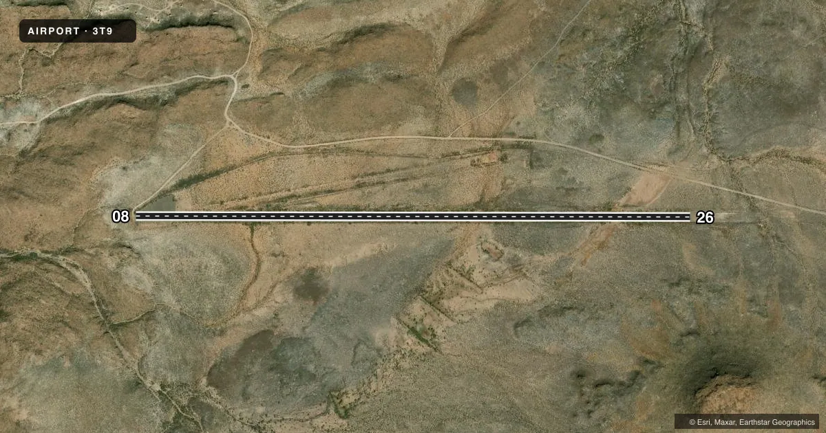
Airport sketch
Runways drawn to scale from FAA survey coordinates, rendered over satellite imagery. Not for navigation.
Approaches & charts
Services on the field
Fuel grades, oxygen, maintenance, ramp storage and lighting — as declared to the FAA by the airport operator.
Fuel & services
- Fuel
- Not available
- Airframe repair
- Not available
- Power plant repair
- Not available
Ramp & ground
- Transient storage
- Not published
- Landing fee
- No fee published
- Wind indicator
- Yes
- Segmented circle
- No
Fuel & FBOs
Cheapest 100LL and Jet A on the field and nearby. Always confirm with the FBO before taxi.
Airport notes
Surface conditions, obstructions, local procedures, lighting outages and other notes published with each FAA cycle.
General notes
- ARPT LCTD 26 MILES FROM RANCH GATE; ROAD VERY ROUGH.
- FOR CD CTC ALBUQUERQUE ARTCC AT 505-856-4861.
- REMOTE AREA, NO CELL PHONE COVERAGE.
- UPON ARRIVAL, CHECK IN AT RANGER STATION, 1 MILE FROM ARPT.
Approach & departure obstructions
- 0810 FT BRUSH AT RWY EDGE.
- 2610 FT BRUSH AT RWY EDGE.
- 0810 FT BRUSH.
- 08HILLS SURROUNDING ARPT.
Other notes
- MANAGERPARK SUPERINTENDENT.
- MANAGEREXT 224. 432-295-0888 CELL.
- 08/26LOOSE STONES ON RWY.
VFR map & nearby airports
VFR sectional. Tap any ICAO chip to open that airport.
Key facts · 3T9
Answer card- ICAO
- 3T9
- Name
- BIG BEND RANCH STATE PARK
- Location
- PRESIDIO, TEXAS
- Elevation
- 4,250 ft MSL
- Traffic pattern altitude
- 5,250 ft MSL (1,000 AGL)
- Control tower
- Non-towered (use CTAF)
- Total runways
- 1
- Longest runway
- 08/26 · 5,500 ft
- Published ILS approaches
- 0
- Published frequencies
- 1
- Magnetic variation
- 9°
- Current flight rules
- VFR
- Current wind
- 010° at 6 kt
- Favored runway now
- RWY 08
Big Bend Ranch State Park Airport sits near Presidio, Texas. The field elevation is 4,250 ft MSL. It has one runway. Runway 08/26 is 5,500 ft long with asphalt and gravel surface. There is no control tower. CTAF is 122.9. No ILS approaches are published.
Pattern altitude is not published. Use the standard 1,000 ft AGL pattern unless the current Chart Supplement says otherwise. That puts the light piston pattern at 5,250 ft MSL. The airport is remote. There is no cell phone coverage. The road to the field is very rough. The airport is 26 miles from the ranch gate. After arrival, check in at the ranger station, which is 1 mile from the airport.
Published remarks also note loose stones on runway 08/26. Brush is reported at the runway edge near both ends. Hills surround the airport near runway 08. That makes the east end the one to study closely before you go in. For clearance delivery, contact Albuquerque ARTCC at 505-856-4861. The park superintendent is the airport manager. Verify current field conditions and any operational limits with the airport operator before departure.