METAR & TAF T89
Current METAR
Observed 18:55Z
KT89 271855Z AUTO 12005G10KT 10SM CLR 37/13 A2994 RMK A01
- Wind
- 120° @ 5G10 kt
- Visibility
- 10 SM
- Temp / Dew
- 37°C / 13°C
- Altimeter
- 29.94 inHg
- Clouds
- CLR
- Density alt
- 5,876 ft
- Ceiling
- Unlimited
- Rules
- VFR
Airport info & contacts
Manager on record, flight service, ARTCC, attendance schedule and pattern altitude — published by the FAA and refreshed every 28 days.
Location
- From city
- 4 NM E
- VFR sectional
- EL PASO
- ARTCC
- ZAB · ALBUQUERQUE
- NOTAM facility
- T89 (NOTAM-D)
Airport manager
- Name
- GARY GRANT
- Phone
- 432-424-3544
- Address
- 1500 N AIRPORT RD, LAJITAS TX 79852
Flight service · Hours
- FSS SJT
- SAN ANGELO1-800-WX-BRIEF
- Attendance
- 0800-1700
Frequencies
Tap any row to copy the frequency to your clipboard.
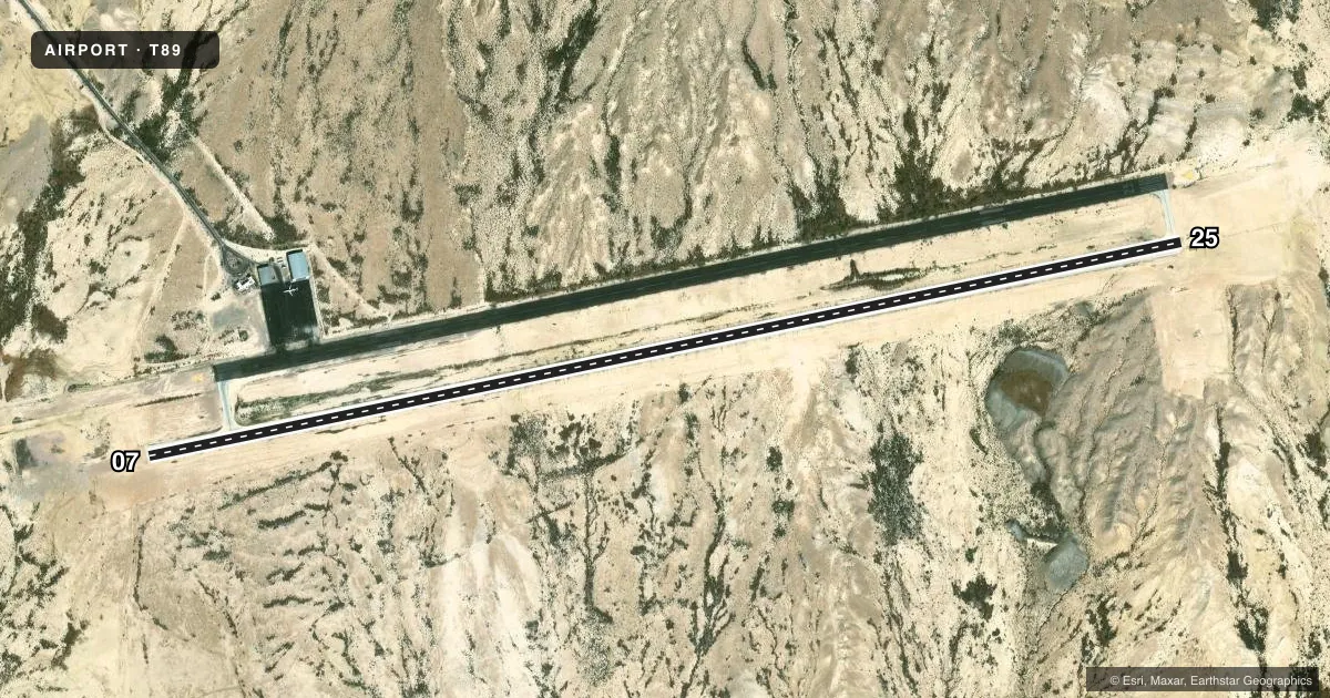
Runways & pattern
Full pagePattern entry · RWY 07
LEFT TRAFFICAirport sketch
Runways drawn to scale from FAA survey coordinates, rendered over satellite imagery. Not for navigation.
Approaches & charts
Services on the field
Fuel grades, oxygen, maintenance, ramp storage and lighting — as declared to the FAA by the airport operator.
Fuel & services
- Fuel
- 100LLA
Ramp & ground
- Transient storage
- Not published
- Landing fee
- Yes
- Lighting schedule
- SEE RMK
- Wind indicator
- Lighted
- Segmented circle
- No
Fuel & FBOs
Cheapest 100LL and Jet A on the field and nearby. Always confirm with the FBO before taxi.
Airport notes
Surface conditions, obstructions, local procedures, lighting outages and other notes published with each FAA cycle.
General notes
- NO TGLS.
- FOR CD CTC ALBUQUERQUE ARTCC AT 505-856-4861.
- NOTICE RQRD FOR ALL INCOMING TFC.
Lighting notes
- FOR NIGHT OPS CALL 432-424-5000. MIRL RWY 7/25 CTAF. TXY LTS ON REQ.
Other notes
- 1FOR SVC CALL 432-424-5000.
- ARPT SUPVRAIRPORT@LAJITASGOLFRESORT.COM
VFR map & nearby airports
VFR sectional. Tap any ICAO chip to open that airport.
Key facts · T89
Answer card- ICAO
- T89
- Name
- LAJITAS INTL
- Location
- LAJITAS, TEXAS
- Elevation
- 2,630 ft MSL
- Traffic pattern altitude
- 3,630 ft MSL (1,000 AGL)
- Control tower
- Non-towered (use CTAF)
- Total runways
- 1
- Longest runway
- 07/25 · 6,501 ft
- Published ILS approaches
- 0
- Published frequencies
- 2
- Magnetic variation
- 9°
- Current flight rules
- VFR
- Current wind
- 120° at 5 kt
- Favored runway now
- RWY 07
Lajitas Intl (T89) sits in Lajitas, Texas at 2,630 ft MSL. It has one runway, 07/25, which is 6,501 ft long and paved concrete. There is no control tower. CTAF and UNICOM are both 122.7. No ILS approaches are published here.
The pattern altitude is not published, so use the standard 1,000 ft AGL for light piston operations unless the current Chart Supplement says otherwise. That puts the pattern at 3,630 ft MSL based on the field elevation. The airport remarks call for notice before arrival. No touch-and-go landings are allowed. For night work, call 432-424-5000. Medium intensity runway lights are on runway 07/25 and are controlled by CTAF. Taxiway lights are available on request.
Lajitas Golf Resort is the on-field FBO. It carries 100LL and Jet A Prist. Pilots needing clearance delivery are told to contact Albuquerque ARTCC at 505-856-4861. This is a desert field near the Big Bend area, so expect hot-day performance planning to matter. Check the current Chart Supplement for any other local procedures before you go.