METAR & TAF KVHN
Current METAR
Observed 22:15Z
KVHN 272215Z AUTO 11013KT 10SM CLR 41/06 A2997 RMK AO2 T04080064
- Wind
- 110° @ 13 kt
- Visibility
- 10 SM
- Temp / Dew
- 41°C / 6°C
- Altimeter
- 29.97 inHg
- Clouds
- CLR
- Density alt
- 7,964 ft
- Ceiling
- Unlimited
- Rules
- VFR
Airport info & contacts
Manager on record, flight service, ARTCC, attendance schedule and pattern altitude — published by the FAA and refreshed every 28 days.
Location
- From city
- 3 NM NE
- VFR sectional
- EL PASO
- ARTCC
- ZAB · ALBUQUERQUE
- NOTAM facility
- ABQ (NOTAM-D)
Airport manager
- Name
- JUDGE CARLOS URIAS
- Phone
- 432-283-2059
- Address
- 501 W. BROADWAY, BOX 927, VAN HORN TX 79855
Flight service · Hours
- FSS ABQ
- ALBUQUERQUE1-800-WX-BRIEF
- Attendance
- 0900-1800
Frequencies
Tap any row to copy the frequency to your clipboard.
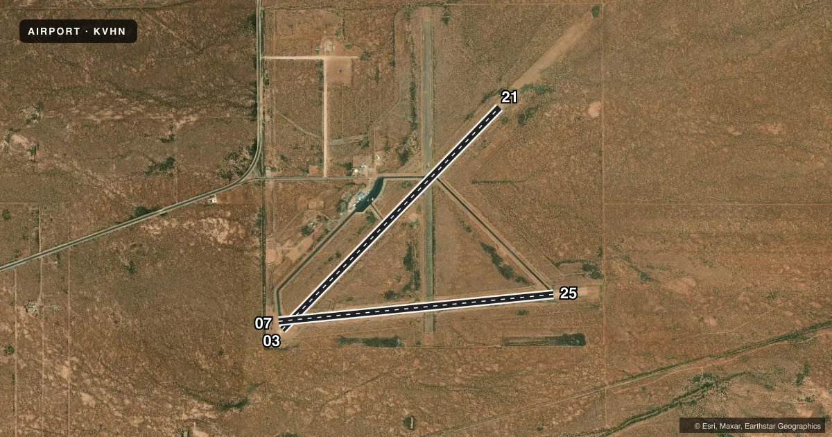
Runways & pattern
Full pagePattern entry · RWY 07
LEFT TRAFFIC| Runway | Heading (°M) | Length | Surface | Traffic |
|---|---|---|---|---|
| 03/21 | 35° / 215° | 6,005 ft | ASPH | Standard L |
| 07/25Favored | 74° / 254° | 5,353 ft | ASPH | Standard L |
Runway end performance
| End | TORA | TODA | ASDA | LDA | VGSI | Approach lights | Obstruction |
|---|---|---|---|---|---|---|---|
| 03 | — | — | — | — | PAPI 2-box left(3°) | — | 10', brush, 270' from thr, 250' R of cntrln, slope 7 |
| 21 | — | — | — | — | PAPI 2-box left(3°) | — | 12', brush, 258' from thr, 130' R of cntrln, slope 4 |
| 07 | — | — | — | — | — | — | 15', brush, 276' from thr, 125' R of cntrln, slope 5 |
Declared distances in feet. TORA = takeoff run available, TODA = takeoff distance, ASDA = accelerate-stop, LDA = landing distance.
Airport sketch
Runways drawn to scale from FAA survey coordinates, rendered over satellite imagery. Not for navigation.
Approaches & charts
Services on the field
Fuel grades, oxygen, maintenance, ramp storage and lighting — as declared to the FAA by the airport operator.
Fuel & services
- Fuel
- 100LLA1+
- Oxygen (bottled)
- Not available
- Oxygen (bulk)
- Not available
Ramp & ground
- Transient storage
- Tie-down
- Landing fee
- No fee published
- Customs
- Not available
- Lighting schedule
- SEE RMK
- Beacon schedule
- SS-SR
- Beacon
- White / Green (civil land)(WG)
- Wind indicator
- Lighted
- Segmented circle
- Yes
Fuel & FBOs
Cheapest 100LL and Jet A on the field and nearby. Always confirm with the FBO before taxi.
Airport notes
Surface conditions, obstructions, local procedures, lighting outages and other notes published with each FAA cycle.
General notes
- FOR CD CTC ALBUQUERQUE ARTCC AT 505-856-4861.
Lighting notes
- ACTVT PAPI RWY 03 & 21; MIRL RWY 03/21 & RWY 07/25 - CTAF.
Fuel notes
- 100LLFOR FUEL CALL 432-283-2237 OR 432-284-1418.
Approach & departure obstructions
- 0310 FT BRUSH, 30 FT DSTC, 250 FT L.
- 2110 FT BRUSH, 0-200 FT DSTC.
VFR map & nearby airports
VFR sectional. Tap any ICAO chip to open that airport.
Key facts · KVHN
Answer card- ICAO
- KVHN
- Name
- CULBERSON COUNTY
- Location
- VAN HORN, TEXAS
- Elevation
- 3,956.8 ft MSL
- Traffic pattern altitude
- 4,956.8 ft MSL (1,000 AGL)
- Control tower
- Non-towered (use CTAF)
- Total runways
- 2
- Longest runway
- 03/21 · 6,005 ft
- Published ILS approaches
- 0
- Published frequencies
- 1
- Magnetic variation
- 10°
- Current flight rules
- VFR
- Current wind
- 110° at 13 kt
- Favored runway now
- RWY 07
Culberson County Airport sits near Van Horn, Texas. Field elevation is 3,956.8 ft MSL. It has two asphalt runways. The longest is 6,005 ft on runway 03/21. Runway 07/25 is 5,353 ft. The airport is not towered. CTAF is 122.9.
No ILS approaches are published here. The published pattern altitude is not listed, so use the current Chart Supplement before you go. The field is in a high desert setting. Density altitude can be a real factor here, especially on warm days. Plan performance with that in mind. The published remarks also note brush near the ends of runway 21 and runway 03. That makes a careful taxi and landing scan worthwhile on those sides.
Lighting is available on both runways. The runway 03 and 21 PAPI is also published. For clearance delivery, Albuquerque ARTCC is listed in the remarks. Culberson County Aviation is on the field. Fuel grades are not reported in the facts, so call the FBO directly before arrival if you need fuel details. For 100LL, the published remarks give phone numbers for current fuel information. If you are new to the airport, review the current Chart Supplement before departure for any updates on procedures, lighting, or local operating notes.