METAR & TAF KCNM
Current METAR
Observed 20:53Z
KCNM 272053Z AUTO 14005G18KT 10SM CLR 40/13 A2991 RMK AO2 SLP059 T04000133 58019
- Wind
- 140° @ 5G18 kt
- Visibility
- 10 SM
- Temp / Dew
- 40°C / 13°C
- Altimeter
- 29.91 inHg
- Clouds
- CLR
- Density alt
- 7,098 ft
- Ceiling
- Unlimited
- Rules
- VFR
Airport info & contacts
Manager on record, flight service, ARTCC, attendance schedule and pattern altitude — published by the FAA and refreshed every 28 days.
Location
- From city
- 5 NM SW
- VFR sectional
- ALBUQUERQUE
- ARTCC
- ZAB · ALBUQUERQUE
- NOTAM facility
- CNM (NOTAM-D)
Airport manager
- Name
- ROBERT ESPINOZA
- Phone
- 575-887-3060
- Address
- 101 NORTH HALAGUENO ST, CARLSBAD NM 88220
Flight service · Hours
- FSS ABQ
- ALBUQUERQUE1-800-WX-BRIEF
- Attendance
- MON-FRI · 0600-2000
- SAT-SUN · 0700-1700
Frequencies
Tap any row to copy the frequency to your clipboard.
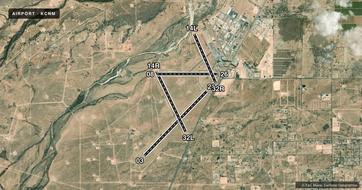
Runways & pattern
Full pagePattern entry · RWY 14R
RIGHT TRAFFIC| Runway | Heading (°M) | Length | Surface | Traffic |
|---|---|---|---|---|
| 03/21 | 34° / 214° | 7,854 ft | ASPH | Standard L |
| 14R/32LFavored | 144° / 324° | 5,837 ft | ASPH | 14R R |
| 08/26 | 80° / 260° | 5,334 ft | ASPH | Standard L |
| 14L/32R | 146° / 326° | 4,616 ft | ASPH | 32R R |
Runway end performance
| End | TORA | TODA | ASDA | LDA | VGSI | Approach lights | Obstruction |
|---|---|---|---|---|---|---|---|
| 03 | 7,854' | 7,854' | 7,504' | 7,504' | — | MALSR | 24', road, 1080' from thr, 623' R of cntrln, slope 36 |
| 21 | 7,854' | 7,854' | 7,854' | 7,854' | VASI 4-box left(3°) | — | 14', road, 388' from thr, 514' R of cntrln, slope 13 |
| 14R | 5,837' | 5,837' | 5,837' | 5,837' | PAPI 4-box left(3°) | — | 7', road, 300' from thr, 150' R of cntrln, slope 14 |
| 32L | 5,837' | 5,837' | 5,837' | 5,452' | PAPI 4-box left(3°) | — | 15', road, 672' from thr, 318' R of cntrln, slope 31 |
| 08 | 5,334' | 5,334' | 5,334' | 5,334' | — | — | 15', road, 310' from thr, 0' R of cntrln, slope 7 |
| 26 | 5,334' | 5,334' | 5,334' | 5,334' | — | — | 4', fence, 200' from thr, 125' R of cntrln, slope 0 |
| 14L | 4,615' | 4,615' | 4,615' | 4,615' | — | — | — |
| 32R | 4,615' | 4,615' | 4,615' | 3,999' | — | — | 15', road, 230' from thr, 150' R of cntrln, slope 0 |
Declared distances in feet. TORA = takeoff run available, TODA = takeoff distance, ASDA = accelerate-stop, LDA = landing distance.
Airport sketch
Runways drawn to scale from FAA survey coordinates, rendered over satellite imagery. Not for navigation.
Approaches & charts
ILS · 1
Services on the field
Fuel grades, oxygen, maintenance, ramp storage and lighting — as declared to the FAA by the airport operator.
Fuel & services
- Fuel
- 100LLA1+
- Other services
- AFRT,AMB
Ramp & ground
- Transient storage
- Tie-down
- Hangar
- Landing fee
- No fee published
- Customs
- Not available
- Lighting schedule
- SEE RMK
- Beacon schedule
- SS-SR
- Beacon
- White / Green (civil land)(WG)
- Wind indicator
- Lighted
- Segmented circle
- Yes
Fuel & FBOs
Cheapest 100LL and Jet A on the field and nearby. Always confirm with the FBO before taxi.
Airport notes
Surface conditions, obstructions, local procedures, lighting outages and other notes published with each FAA cycle.
General notes
- OIL DERRICKS INVOF ARPT.
- FOR CD IF UNA TO CTC ON FSS FREQ, CTC ALBUQUERQUE ARTCC AT 505-856-4561.
Lighting notes
- ACTVT MALSR RWY 03; MIRL RWY 03/21, 08/26 & 14R/32L - CTAF. MALSR RWY 03 & MIRL RWY 03/21, 08/26, 14R/32L PRESET LOW INTST; INCR INTST - CTAF.
Fuel notes
- 100LLFUEL AFT HR & WKEND - 575-887-1500.
Runway surface & condition
- 03/21PCR VALUE: 180/F/D/X/T
- 08/26PCR VALUE: 110/F/D/X/T
- 14L/32RPCR VALUE: 50/F/D/X/T
- 14R/32LPCR VALUE: 230/F/D/X/T
- 14L/32RRWY 14L/32R NOT AVBL FOR PART 121/PART 380 OPS WITH SKED PAX CARRYING OPS MORE THAN 9 PAX SEATS AND NON-SKED PAX CARRYING OPS MORE THAN 30 PAX SEATS.
Approach & departure obstructions
- 32LAPCH SLOPE 50:1 FM DTHR.
- 32RAPCH SLOPE 38:1 FM DTHR.
Other notes
- ACR OPS MORE THAN 30 PAX SEATS 24 HR PPR - AMGR.
- 1SFC COND UNMTD MON-FRI 2200-1200 UTC (1500-0500 LOCAL) AND SAT-SUN 2030-1200 UTC (1330-0500 LOCAL).
VFR map & nearby airports
VFR sectional. Tap any ICAO chip to open that airport.
Key facts · KCNM
Answer card- ICAO
- KCNM
- Name
- CAVERN CITY AIR TRML
- Location
- CARLSBAD, NEW MEXICO
- Elevation
- 3,294.6 ft MSL
- Traffic pattern altitude
- 4,294.6 ft MSL (1,000 AGL)
- Control tower
- Non-towered (use CTAF)
- Total runways
- 4
- Longest runway
- 03/21 · 7,854 ft
- Published ILS approaches
- 1
- Published frequencies
- 2
- Magnetic variation
- 10°
- Current flight rules
- VFR
- Current wind
- 140° at 5 kt
- Favored runway now
- RWY 14R
CAVERN CITY AIR TRML is in Carlsbad, New Mexico. The field elevation is 3,294.6 ft MSL. It has four asphalt runways. The longest is runway 03/21 at 7,854 ft. There is no control tower, so plan on CTAF and UNICOM 123.0 for local traffic calls.
Runway 03 has the only published ILS approach. The pattern altitude is not published in the facts, so use standard 1,000 ft AGL for light piston operations unless the current FAA Chart Supplement says otherwise. The airport sits in southeastern New Mexico, so density altitude can be a real factor in warm weather. That matters here because you are already starting from a higher field elevation.
Chandler Aviation is on the field. It carries 100LL and Jet A. After-hours 100LL is available by phone at (575) 887-1500. The published remarks also note that runway surface condition is not monitored during certain overnight and weekend windows, so check current conditions before you go. Runway 14L/32R is not available for certain large passenger operations. The airport also has runway lighting and approach lighting on runway 03, with intensity controlled on CTAF.