METAR & TAF KMRF
Current METAR
Observed 22:27Z
KMRF 272227Z AUTO 16009KT 10SM CLR 36/13 A3005 RMK AO2 WSHFT 2207 $
- Wind
- 160° @ 9 kt
- Visibility
- 10 SM
- Temp / Dew
- 36°C / 13°C
- Altimeter
- 30.05 inHg
- Clouds
- CLR
- Density alt
- 8,371 ft
- Ceiling
- Unlimited
- Rules
- VFR
Airport info & contacts
Manager on record, flight service, ARTCC, attendance schedule and pattern altitude — published by the FAA and refreshed every 28 days.
Location
- From city
- 3 NM N
- VFR sectional
- EL PASO
- ARTCC
- ZAB · ALBUQUERQUE
- NOTAM facility
- MRF (NOTAM-D)
Airport manager
- Name
- RUDY ESTOR
- Phone
- 432-295-3906
- Address
- 45101 SH 17, MARFA TX 79843
Flight service · Hours
- FSS SJT
- SAN ANGELO1-800-WX-BRIEF
- Attendance
- 0800-1600
Frequencies
Tap any row to copy the frequency to your clipboard.
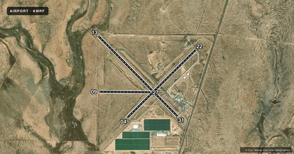
Runways & pattern
Full pagePattern entry · RWY 13
LEFT TRAFFIC| Runway | Heading (°M) | Length | Surface | Traffic |
|---|---|---|---|---|
| 13/31Favored | 127° / 307° | 6,203 ft | ASPH | Standard L |
| 04/22 | 37° / 217° | 5,309 ft | ASPH | Standard L |
| 09/27 | 83° / 263° | 2,825 ft | DIRT | Standard L |
Runway end performance
| End | TORA | TODA | ASDA | LDA | VGSI | Approach lights | Obstruction |
|---|---|---|---|---|---|---|---|
| 13 | — | — | — | — | PAPI 2-box left(3°) | — | — |
| 31 | — | — | — | — | PAPI 2-box left(3°) | — | 19', tree, 870' from thr, 250' R of cntrln, slope 35 |
| 09 | — | — | — | — | — | — | 4', fence, 132' from thr, 0' R of cntrln, slope 33 |
Declared distances in feet. TORA = takeoff run available, TODA = takeoff distance, ASDA = accelerate-stop, LDA = landing distance.
Airport sketch
Runways drawn to scale from FAA survey coordinates, rendered over satellite imagery. Not for navigation.
Approaches & charts
Services on the field
Fuel grades, oxygen, maintenance, ramp storage and lighting — as declared to the FAA by the airport operator.
Fuel & services
- Fuel
- 100LLA
- Oxygen (bottled)
- Not available
- Oxygen (bulk)
- Not available
- Airframe repair
- Not available
- Power plant repair
- Not available
- Other services
- INSTR,TOW
Ramp & ground
- Transient storage
- Tie-down
- Landing fee
- Yes
- Customs
- Not available
- Lighting schedule
- SEE RMK
- Beacon schedule
- SS-SR
- Beacon
- White / Green (civil land)(WG)
- Wind indicator
- Lighted
- Segmented circle
- Yes
Fuel & FBOs
Cheapest 100LL and Jet A on the field and nearby. Always confirm with the FBO before taxi.
Airport notes
Surface conditions, obstructions, local procedures, lighting outages and other notes published with each FAA cycle.
General notes
- 105 FT AGL LGTD WATER TWR 1168 FT SW OF AER 31.
- GLIDER OPNS ON & INVOF ARPT.
- WILDLIFE ON & INVOF ARPT.
- PARL TWY ADJ RWY 04/22 CLSD EXC BTN TWY A AND RWY 13/31.
- FOR CD IF UNA TO CTC ON FSS FREQ, CTC ALBUQUERQUE ARTCC AT 505-856-4561.
- TWY A NORTHWEST OF RWY 04/22 CLSD TO ACFT MORE THAN 18000 LB.
- RWY 9 THLD MKD W/3 WHITE TIRES EACH SIDE OF RWY CNTRLN.
Lighting notes
- MIRL RWY 13/31 PRESET LOW INTST; TO INCR INTST ACTVT - CTAF.
Fuel notes
- 100LL100LL, JET-A, SELF SERVE AVLBL 24 HRS.
Approach & departure obstructions
- 0412 FT TREE, 24 FT DSTC, 230 FT R.
Other notes
- LDG FEE WAIVED WITH MIN FUEL PURCHASE.
- INSTRGLIDER INSTRUCTION ONLY
VFR map & nearby airports
VFR sectional. Tap any ICAO chip to open that airport.
Key facts · KMRF
Answer card- ICAO
- KMRF
- Name
- MARFA MUNI
- Location
- MARFA, TEXAS
- Elevation
- 4,848.8 ft MSL
- Traffic pattern altitude
- 5,848.8 ft MSL (1,000 AGL)
- Control tower
- Non-towered (use CTAF)
- Total runways
- 3
- Longest runway
- 13/31 · 6,203 ft
- Published ILS approaches
- 0
- Published frequencies
- 2
- Magnetic variation
- 8°
- Current flight rules
- VFR
- Current wind
- 160° at 9 kt
- Favored runway now
- RWY 13
Marfa Muni sits in Marfa, Texas. Field elevation is 4,848.8 ft MSL. The airport has three runways. The longest is runway 13/31 at 6,203 ft. There is no control tower. CTAF and UNICOM are both 122.8. No ILS approaches are published.
Pattern altitude is not published. Use 1,000 ft AGL for light piston operations unless the current Chart Supplement says otherwise. That puts the normal pattern about 5,849 ft MSL. The field is in a high-desert setting, so density altitude will matter on warm days. Glider operations are on and in the vicinity of the airport. Wildlife is also reported nearby.
Marfa Municipal Airport is the on-field FBO. It carries 100LL and Jet-A. Self-serve fuel is available 24 hours. The published remarks also say the landing fee is waived with a minimum fuel purchase. Runway 13/31 has medium intensity lights that start at low intensity. Key the CTAF to increase them. Be careful with runway 04/22. The parallel taxiway beside it is closed except between taxiway A and runway 13/31. Taxiway A northwest of runway 04/22 is closed to aircraft over 18,000 pounds. There is also a 12 ft tree 24 ft right of the runway 04 threshold area. Check the current Chart Supplement before you go. This field also has a lighted water tower southwest of the airport reference point.