METAR & TAF KODO
Current METAR
Observed 19:53Z
KODO 271953Z AUTO 14008G17KT 10SM CLR 37/13 A2996 RMK AO2 SLP089 T03670128 $
- Wind
- 140° @ 8G17 kt
- Visibility
- 10 SM
- Temp / Dew
- 37°C / 13°C
- Altimeter
- 29.96 inHg
- Clouds
- CLR
- Density alt
- 6,315 ft
- Ceiling
- Unlimited
- Rules
- VFR
Airport info & contacts
Manager on record, flight service, ARTCC, attendance schedule and pattern altitude — published by the FAA and refreshed every 28 days.
Location
- From city
- 5 NM NE
- VFR sectional
- SAN ANTONIO
- ARTCC
- ZFW · FORT WORTH
- NOTAM facility
- ODO (NOTAM-D)
Airport manager
- Name
- JON CRAIN
- Phone
- 432-367-5881
- Address
- 200 EAST TERMINAL DR, ODESSA TX 79765
Flight service · Hours
- FSS SJT
- SAN ANGELO1-800-WX-BRIEF
- Attendance
- 0600-2000
Frequencies
Tap any row to copy the frequency to your clipboard.
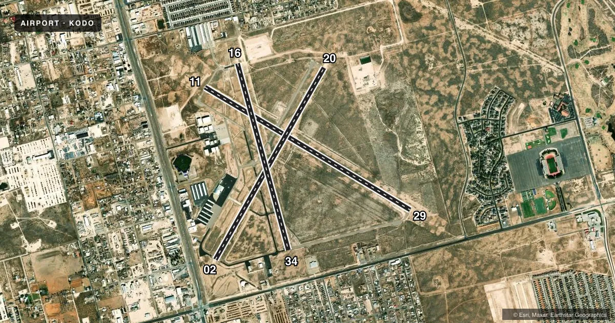
Runways & pattern
Full pagePattern entry · RWY 11
LEFT TRAFFIC| Runway | Heading (°M) | Length | Surface | Traffic |
|---|---|---|---|---|
| 11/29Favored | 113° / 293° | 6,200 ft | ASPH | Standard L |
| 02/20 | 22° / 202° | 5,703 ft | ASPH | Standard L |
| 16/34 | 157° / 337° | 5,003 ft | ASPH | Standard L |
Runway end performance
| End | TORA | TODA | ASDA | LDA | VGSI | Approach lights | Obstruction |
|---|---|---|---|---|---|---|---|
| 11 | — | — | — | — | PAPI 4-box left(3°) | MALS | 75', other, 2500' from thr, 275' R of cntrln, slope 30 |
| 29 | — | — | — | — | PAPI 4-box left(3°) | MALS | 30', pline, 1350' from thr, 246' R of cntrln, slope 38 |
| 02 | — | — | — | — | PAPI 2-box left(3°) | — | 15', road, 500' from thr, 270' R of cntrln, slope 20 |
| 20 | — | — | — | — | PAPI 2-box left(3°) | — | 30', pline, 1220' from thr, 310' R of cntrln, slope 34 |
| 16 | — | — | — | — | PAPI 2-box left(4°) | — | 45', ant, 1104' from thr, 120' R of cntrln, slope 20 |
| 34 | — | — | — | — | PAPI 2-box left(4°) | — | 30', pline, 960' from thr, 250' R of cntrln, slope 25 |
Declared distances in feet. TORA = takeoff run available, TODA = takeoff distance, ASDA = accelerate-stop, LDA = landing distance.
Airport sketch
Runways drawn to scale from FAA survey coordinates, rendered over satellite imagery. Not for navigation.
Approaches & charts
Services on the field
Fuel grades, oxygen, maintenance, ramp storage and lighting — as declared to the FAA by the airport operator.
Fuel & services
- Fuel
- 100LLA
- Oxygen (bottled)
- Low pressure
- Airframe repair
- Major
- Power plant repair
- Major
- Other services
- INSTR,RNTL
Ramp & ground
- Transient storage
- Tie-down
- Hangar
- Landing fee
- No fee published
- Customs
- Not available
- Lighting schedule
- SEE RMK
- Beacon schedule
- SS-SR
- Beacon
- White / Green (civil land)(WG)
- Wind indicator
- Lighted
- Segmented circle
- Yes
Fuel & FBOs
Cheapest 100LL and Jet A on the field and nearby. Always confirm with the FBO before taxi.
Airport notes
Surface conditions, obstructions, local procedures, lighting outages and other notes published with each FAA cycle.
General notes
- FOR CD WHEN 121.7 IS OTS CTC MIDLAND APCH AT 432-563-2123. WHEN APCH CLSD CTC FORT WORTH ARTCC AT 817-858-7584.
- WILDLIFE ACTVY ON AND INVOF ARPT.
- RWY 11, 170 FT LGTD TWR, 2500 FT NW OF RWY 11 END.
Lighting notes
- MIRL RWYS 02/20, 11/29, 16/34 PRESET LOW; TO INCR INTST - CTAF.
Fuel notes
- 100LLFOR FUEL AFT HRS CALL 432-367-5881 OR SELF SERVE.
Approach & departure obstructions
- 1175 FT BILLBOARD; ALSO 50 FT MKD & LGTD PLINE, 2070 FT FM RWY END 37:1.
Other notes
- ARPT BOARDWKENWORTHY54@GMAIL.COM
VFR map & nearby airports
VFR sectional. Tap any ICAO chip to open that airport.
Key facts · KODO
Answer card- ICAO
- KODO
- Name
- ODESSA-SCHLEMEYER FLD
- Location
- ODESSA, TEXAS
- Elevation
- 3,003.6 ft MSL
- Traffic pattern altitude
- 4,003.6 ft MSL (1,000 AGL)
- Control tower
- Non-towered (use CTAF)
- Total runways
- 3
- Longest runway
- 11/29 · 6,200 ft
- Published ILS approaches
- 0
- Published frequencies
- 5
- Magnetic variation
- 8°
- Current flight rules
- VFR
- Current wind
- 140° at 8 kt
- Favored runway now
- RWY 11
Odessa-Schlemeyer Field sits in Odessa, Texas. The field elevation is 3,003.6 ft MSL. It has three asphalt runways. The longest is runway 11/29 at 6,200 ft. There is no control tower. No ILS approaches are published here.
Pattern altitude is not published. Use 1,000 ft AGL for light piston traffic unless the current FAA Chart Supplement says otherwise. The airport is busy enough to warrant a close look at the local setup before you arrive. Wildlife activity is reported on and near the airport. Runway 11 also has a 170-foot lighted tower about 2,500 ft northwest of the runway 11 end. There is also a billboard and a marked lighted power line near that end. Plan your approach with that in mind.
Odessa-Schlemeyer Field has one on-field FBO. Odessa-Schlemeyer Field carries AVGAS 100LL, JET A and JET A Prist. After-hours fuel is available by calling the field or using self-serve. Runway lights on 02/20, 11/29 and 16/34 are preset to low intensity. Use CTAF if you need them brighter. For clearances, Midland Approach handles the published clearance delivery and approach frequencies. If those are out, check the current FAA Chart Supplement for the backup contact details before you go.