METAR & TAF KMDD
Current METAR
Observed 21:55Z
KMDD 042155Z AUTO 11009KT 10SM CLR 37/12 A2999 RMK AO2 T03710120
- Wind
- 110° @ 9 kt
- Visibility
- 10 SM
- Temp / Dew
- 37°C / 12°C
- Altimeter
- 29.99 inHg
- Clouds
- CLR
- Density alt
- 6,032 ft
- Ceiling
- Unlimited
- Rules
- VFR
Airport info & contacts
Manager on record, flight service, ARTCC, attendance schedule and pattern altitude — published by the FAA and refreshed every 28 days.
Location
- From city
- 3 NM N
- VFR sectional
- ALBUQUERQUE
- ARTCC
- ZFW · FORT WORTH
- NOTAM facility
- MDD (NOTAM-D)
Airport manager
- Name
- JUSTINE RUFF
- Phone
- 432-560-2200
- Address
- PO BOX 60305, MIDLAND TX 79711
Flight service · Hours
- FSS SJT
- SAN ANGELO1-800-WX-BRIEF
- Attendance
- M-F · 0600-2000
- S-S · 0700-2000
Frequencies
Tap any row to copy the frequency to your clipboard.
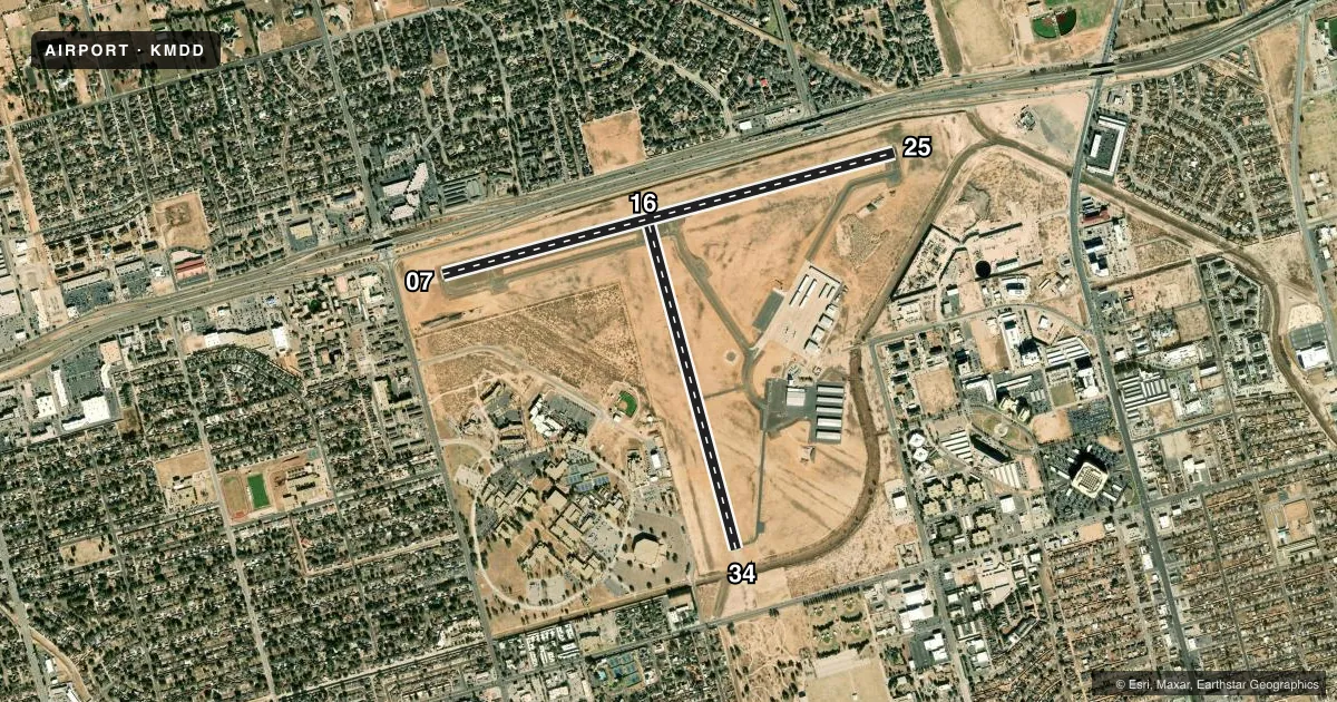
Runways & pattern
Full pagePattern entry · RWY 07
LEFT TRAFFIC| Runway | Heading (°M) | Length | Surface | Traffic |
|---|---|---|---|---|
| 07/25Favored | 68° / 248° | 5,571 ft | ASPH | 25 R |
| 16/34 | 158° / 338° | 3,839 ft | ASPH | 34 R |
Runway end performance
| End | TORA | TODA | ASDA | LDA | VGSI | Approach lights | Obstruction |
|---|---|---|---|---|---|---|---|
| 07 | 5,571' | 5,571' | 5,571' | 5,022' | PAPI 2-box left(3°) | — | 33', pole, 705' from thr, 0' R of cntrln, slope 15 |
| 25 | — | — | — | — | VASI 4-box left(3°) | — | 53', pole, 2010' from thr, 480' R of cntrln, slope 34 |
| 16 | — | — | — | — | PAPI 2-box left(3°) | — | 15', road, 495' from thr, 0' R of cntrln, slope 19 |
| 34 | — | — | — | — | PAPI 2-box left(3°) | — | 38', trees, 840' from thr, 219' R of cntrln, slope 16 |
Declared distances in feet. TORA = takeoff run available, TODA = takeoff distance, ASDA = accelerate-stop, LDA = landing distance.
Airport sketch
Runways drawn to scale from FAA survey coordinates, rendered over satellite imagery. Not for navigation.
Approaches & charts
Services on the field
Fuel grades, oxygen, maintenance, ramp storage and lighting — as declared to the FAA by the airport operator.
Fuel & services
- Fuel
- 100LLA
- Oxygen (bottled)
- High pressure
- Oxygen (bulk)
- High pressure
- Airframe repair
- Major
- Power plant repair
- Major
- Other services
- AMB,AVNCS,CHTR,INSTR,RNTL,SALES
Ramp & ground
- Transient storage
- Tie-down
- Hangar
- Landing fee
- No fee published
- Customs
- Not available
- Lighting schedule
- SEE RMK
- Beacon schedule
- SS-SR
- Beacon
- White / Green (civil land)(WG)
- Wind indicator
- Lighted
- Segmented circle
- Yes
Fuel & FBOs
Cheapest 100LL and Jet A on the field and nearby. Always confirm with the FBO before taxi.
Airport notes
Surface conditions, obstructions, local procedures, lighting outages and other notes published with each FAA cycle.
General notes
- BIRDS INVOF ARPT (SEASONAL).
- FOR CD WHEN 121.8 IS OTS CTC MIDLAND APCH AT 432-563-2123. WHEN APCH CLSD CTC FORT WORTH ARTCC AT 817-858-7584.
- OPRS ON NON-PAVED SFCS ARE PROHIBITED WITHOUT 24 HR PPR.
Lighting notes
- MIRL RWYS 07/25 & 16/34 PRESET LOW INTST; TO INCR INTST & ACTVT VASI RWY 25; PAPI RWYS 07, 16 & 34 - CTAF.
Fuel notes
- 100LLFOR FUEL AFT HRS CALL 432-685-7000.
Approach & departure obstructions
- 07APCH SLOPE AT DSPLCD THR 38:1.
Other notes
- MANAGEREXT 3001
VFR map & nearby airports
VFR sectional. Tap any ICAO chip to open that airport.
Key facts · KMDD
Answer card- ICAO
- KMDD
- Name
- MIDLAND AIRPARK
- Location
- MIDLAND, TEXAS
- Elevation
- 2,805.1 ft MSL
- Traffic pattern altitude
- 3,805.1 ft MSL (1,000 AGL)
- Control tower
- Non-towered (use CTAF)
- Total runways
- 2
- Longest runway
- 07/25 · 5,571 ft
- Published ILS approaches
- 0
- Published frequencies
- 5
- Magnetic variation
- 7°
- Current flight rules
- VFR
- Current wind
- 110° at 9 kt
- Favored runway now
- RWY 07
Midland Airpark sits in Midland, Texas. Field elevation is 2,805.4 ft MSL. The airport has two asphalt runways. The longest is runway 07/25 at 5,571 ft. There is no control tower. No ILS approaches are published here.
Pattern altitude is not published. Use the standard 1,000 ft AGL pattern for light piston aircraft unless the current FAA Chart Supplement says otherwise. Basin Aviation is on the field. It carries 100LL and Jet A Prist. Call (432) 685-7000 for current service details or after-hours fuel. The airport remarks also note that non-paved surface operations are prohibited without 24 hours prior permission. Seasonal bird activity is reported in the area.
Runway lighting is set to low intensity by default. Pilots can use the CTAF to increase intensity. They can also activate the VASI on runway 25 or the PAPI on runways 07, 16 and 34. The field has published approach and departure frequencies for Midland. If clearance delivery on 121.8 is out of service, contact Midland Approach. If approach is closed, contact Fort Worth ARTCC. For a first visit, plan for a busy West Texas environment with no ILS and a field elevation above 2,800 ft MSL. Check density altitude, especially in warm weather.