METAR & TAF KBPG
Current METAR
Observed 15:35Z
KBPG 271535Z AUTO 18011KT 10SM CLR 30/18 A3001 RMK AO2 T02990183
- Wind
- 180° @ 11 kt
- Visibility
- 10 SM
- Temp / Dew
- 30°C / 18°C
- Altimeter
- 30.01 inHg
- Clouds
- CLR
- Density alt
- 4,879 ft
- Ceiling
- Unlimited
- Rules
- VFR
Airport info & contacts
Manager on record, flight service, ARTCC, attendance schedule and pattern altitude — published by the FAA and refreshed every 28 days.
Location
- From city
- 2 NM SW
- VFR sectional
- DALLAS-FT WORTH
- ARTCC
- ZFW · FORT WORTH
- NOTAM facility
- BPG (NOTAM-D)
Airport manager
- Name
- MICHAEL FEELEY
- Phone
- 432-264-2362
- Address
- 3200 RICKABAUGH DRIVE WEST, BIG SPRING TX 79720
Flight service · Hours
- FSS SJT
- SAN ANGELO1-800-WX-BRIEF
- Attendance
- MON-FRI · 0800-1700
Frequencies
Tap any row to copy the frequency to your clipboard.
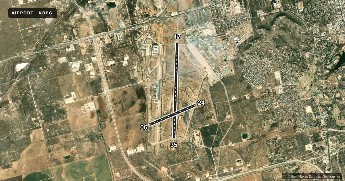
Runways & pattern
Full pagePattern entry · RWY 17
RIGHT TRAFFIC| Runway | Heading (°M) | Length | Surface | Traffic |
|---|---|---|---|---|
| 17/35Favored | 175° / 355° | 8,803 ft | CONC | 17 R |
| 06/24 | 60° / 240° | 4,601 ft | ASPH | 06 R |
Runway end performance
| End | TORA | TODA | ASDA | LDA | VGSI | Approach lights | Obstruction |
|---|---|---|---|---|---|---|---|
| 17 | — | — | — | — | PAPI 4-box left(3°) | SSALS | — |
| 35 | — | — | — | — | PAPI 4-box left(3°) | — | — |
| 06 | — | — | — | — | PAPI 2-box left(3°) | — | — |
| 24 | — | — | — | — | PAPI 2-box left(3°) | — | 5', fence, 200' from thr, 332' R of cntrln, slope 0 |
Declared distances in feet. TORA = takeoff run available, TODA = takeoff distance, ASDA = accelerate-stop, LDA = landing distance.
Airport sketch
Runways drawn to scale from FAA survey coordinates, rendered over satellite imagery. Not for navigation.
Approaches & charts
Services on the field
Fuel grades, oxygen, maintenance, ramp storage and lighting — as declared to the FAA by the airport operator.
Fuel & services
- Fuel
- 100LLA
- Airframe repair
- Major
- Power plant repair
- Major
- Other services
- AGRI,INSTR
Ramp & ground
- Transient storage
- Tie-down
- Hangar
- Landing fee
- No fee published
- Lighting schedule
- SEE RMK
- Beacon schedule
- SS-SR
- Beacon
- White / Green (civil land)(WG)
- Wind indicator
- Lighted
- Segmented circle
- Yes
Fuel & FBOs
Cheapest 100LL and Jet A on the field and nearby. Always confirm with the FBO before taxi.
Airport notes
Surface conditions, obstructions, local procedures, lighting outages and other notes published with each FAA cycle.
General notes
- FBO 432-264-7124. AFT HRS 432-935-1238.
- SANDHILL CRANES XNG IN THE SPRING & FALL.
- PRAIRIE DOGS ON RWYS & TWYS.
- FOR CD CTC FORT WORTH ARTCC AT 817-858-7584.
- 100 LL & JET-A FULL & SELF SERVE.
Lighting notes
- MIRL RWYS 06/24 & 17/35 PRESET LOW INTST; TO INCR INTST & ACTVT SSALS RWY 17 - CTAF.
Other notes
- MANAGERMGR CELL 432-466-3385.
VFR map & nearby airports
VFR sectional. Tap any ICAO chip to open that airport.
Key facts · KBPG
Answer card- ICAO
- KBPG
- Name
- BIG SPRING/MC MAHON-WRINKLE
- Location
- BIG SPRING, TEXAS
- Elevation
- 2,572.8 ft MSL
- Traffic pattern altitude
- 3,572.8 ft MSL (1,000 AGL)
- Control tower
- Non-towered (use CTAF)
- Total runways
- 2
- Longest runway
- 17/35 · 8,803 ft
- Published ILS approaches
- 0
- Published frequencies
- 2
- Magnetic variation
- 7°
- Current flight rules
- VFR
- Current wind
- 180° at 11 kt
- Favored runway now
- RWY 17
Big Spring/MC Mahon-Wrinkle Airport sits in Big Spring, Texas. Field elevation is 2,572.8 ft MSL. The airport has two runways. The longest is 17/35 at 8,803 ft. Runway 06/24 is 4,601 ft. There is no control tower. CTAF and UNICOM are both 122.8.
No ILS approaches are published here. Pattern altitude is not published, so use the standard 1,000 ft AGL for light piston operations unless the current Chart Supplement says otherwise. That puts the pattern at about 3,572.8 ft MSL based on the published field elevation.
Galaxy FBO is on the field. It carries 100LL, Jet A and Jet A Prist. The published remarks also say full-service and self-service fuel are available. The airport remarks note that prairie dogs are on runways and taxiways. Sandhill cranes cross in spring and fall. That matters for taxi and takeoff planning. Runway lights on 06/24 and 17/35 are preset to low intensity. Use the CTAF to brighten them. The same CTAF call also activates the steady-burning approach lights on runway 17.
This is a high-elevation West Texas field. Expect density altitude to matter, especially on warm days. Check the current Chart Supplement for any other operational notes before you go. For clearance delivery, contact Fort Worth ARTCC at 817-858-7584.