METAR & TAF 63F
63F does not publish a METAR.
Showing the nearest reporting station: KBPG (BIG SPRING/MC MAHON-WRINKLE) · 15.5 NM away. Conditions at 63F may differ.
METAR · KBPG
Observed 16:35Z
KBPG 271635Z AUTO 21010G17KT 10SM CLR 32/18 A3000 RMK AO2 T03220176
- Wind
- 210° @ 10G17 kt
- Visibility
- 10 SM
- Temp / Dew
- 32°C / 18°C
- Altimeter
- 30.00 inHg
- Clouds
- CLR
- Density alt
- 5,327 ft
- Ceiling
- Unlimited
- Rules
- VFR
Airport info & contacts
Manager on record, flight service, ARTCC, attendance schedule and pattern altitude — published by the FAA and refreshed every 28 days.
Location
- From city
- 3 NM NW
- VFR sectional
- DALLAS-FT WORTH
- ARTCC
- ZFW · FORT WORTH
- NOTAM facility
- SJT (NOTAM-D)
Airport manager
- Name
- JESSIE MONTEZ, CITY MGR
- Phone
- 432-756-3301
- Address
- PO BOX 370, STANTON TX 79782
Flight service · Hours
- FSS SJT
- SAN ANGELO1-800-WX-BRIEF
- Attendance
- Unattended
Frequencies
Tap any row to copy the frequency to your clipboard.
Runways & pattern
Full pagePattern entry · RWY 16
RIGHT TRAFFICRunway end performance
| End | TORA | TODA | ASDA | LDA | VGSI | Approach lights | Obstruction |
|---|---|---|---|---|---|---|---|
| 16 | — | — | — | — | — | — | 15', road, 520' from thr, 0' R of cntrln, slope 21 |
| 34 | — | — | — | — | — | — | 15', road, 520' from thr, 0' R of cntrln, slope 21 |
Declared distances in feet. TORA = takeoff run available, TODA = takeoff distance, ASDA = accelerate-stop, LDA = landing distance.
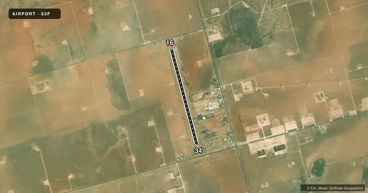
Airport sketch
Runways drawn to scale from FAA survey coordinates, rendered over satellite imagery. Not for navigation.
Approaches & charts
Services on the field
Fuel grades, oxygen, maintenance, ramp storage and lighting — as declared to the FAA by the airport operator.
Fuel & services
- Fuel
- Not available
- Oxygen (bottled)
- Not available
- Oxygen (bulk)
- Not available
- Other services
- AGRI
Ramp & ground
- Transient storage
- Tie-down
- Landing fee
- No fee published
- Customs
- Not available
- Lighting schedule
- SEE RMK
- Beacon
- White / Green (civil land)(WG)
- Wind indicator
- Yes
- Segmented circle
- Yes
Fuel & FBOs
Cheapest 100LL and Jet A on the field and nearby. Always confirm with the FBO before taxi.
Airport notes
Surface conditions, obstructions, local procedures, lighting outages and other notes published with each FAA cycle.
General notes
- NMRS 389 FT WIND TURBINES SRNDG THE ARPT AS CLOSE AS 3/4 MILE.
- FOR CD CTC MIDLAND APCH AT 432-563-2123. WHEN APCH CLSD CTC FORT WORTH ARTCC AT 817-858-7584.
Lighting notes
- ACTVT MIRL RWY 16/34 - CTAF.
Approach & departure obstructions
- 16SCATTERED BRUSH 0-200 FT FM THR ACRS APCH.
- 34SCATTERED BRUSH 0-200 FT FM THR ACRS APCH.
VFR map & nearby airports
VFR sectional. Tap any ICAO chip to open that airport.
Key facts · 63F
Answer card- ICAO
- 63F
- Name
- STANTON MUNI
- Location
- STANTON, TEXAS
- Elevation
- 2,731 ft MSL
- Traffic pattern altitude
- 3,731 ft MSL (1,000 AGL)
- Control tower
- Non-towered (use CTAF)
- Total runways
- 1
- Longest runway
- 16/34 · 4,240 ft
- Published ILS approaches
- 0
- Published frequencies
- 1
- Magnetic variation
- 9°
- Current flight rules
- VFR
- Current wind
- 210° at 10 kt
- Favored runway now
- RWY 16
Stanton Muni sits in Stanton, Texas at 2,731 ft MSL. It has one runway, 16/34, which is 4,240 ft long with an asphalt surface. There is no control tower. CTAF is 122.9. No ILS approaches are published here.
The published pattern altitude is not listed, so use the standard 1,000 ft AGL pattern unless the current FAA Chart Supplement says otherwise. That puts the light aircraft pattern at 3,731 ft MSL based on the field elevation. The airport sits in a part of west Texas with a lot of wind energy development. There are numerous 389 ft wind turbines around the field, some as close as three quarters of a mile away. That is worth keeping in mind on arrival and departure, especially in marginal visibility.
The published remarks also call out scattered brush near both runway thresholds. Check the approach end of 16 and 34 carefully before landing. There are no on-field FBOs listed, so verify fuel and services with the airport operator or call the field on CTAF before you go. For clearance delivery, contact Midland Approach at 432-563-2123. When Midland Approach is closed, contact Fort Worth ARTCC at 817-858-7584.