METAR & TAF E57
Current METAR
Observed 18:15Z
KE57 271815Z AUTO 15008G13KT 10SM CLR 36/09 A3002 RMK AO2
- Wind
- 150° @ 8G13 kt
- Visibility
- 10 SM
- Temp / Dew
- 36°C / 9°C
- Altimeter
- 30.02 inHg
- Clouds
- CLR
- Density alt
- 6,829 ft
- Ceiling
- Unlimited
- Rules
- VFR
Airport info & contacts
Manager on record, flight service, ARTCC, attendance schedule and pattern altitude — published by the FAA and refreshed every 28 days.
Location
- From city
- 1 NM NW
- VFR sectional
- ALBUQUERQUE
- ARTCC
- ZFW · FORT WORTH
- NOTAM facility
- FTW (NOTAM-D)
Airport manager
- Name
- STAN DAVID
- Phone
- 806-592-5426
- Address
- PO BOX 1539, DENVER CITY TX 79323
Flight service · Hours
- FSS FTW
- FORT WORTH1-800-WX-BRIEF
- Attendance
- IREG
Frequencies
Tap any row to copy the frequency to your clipboard.
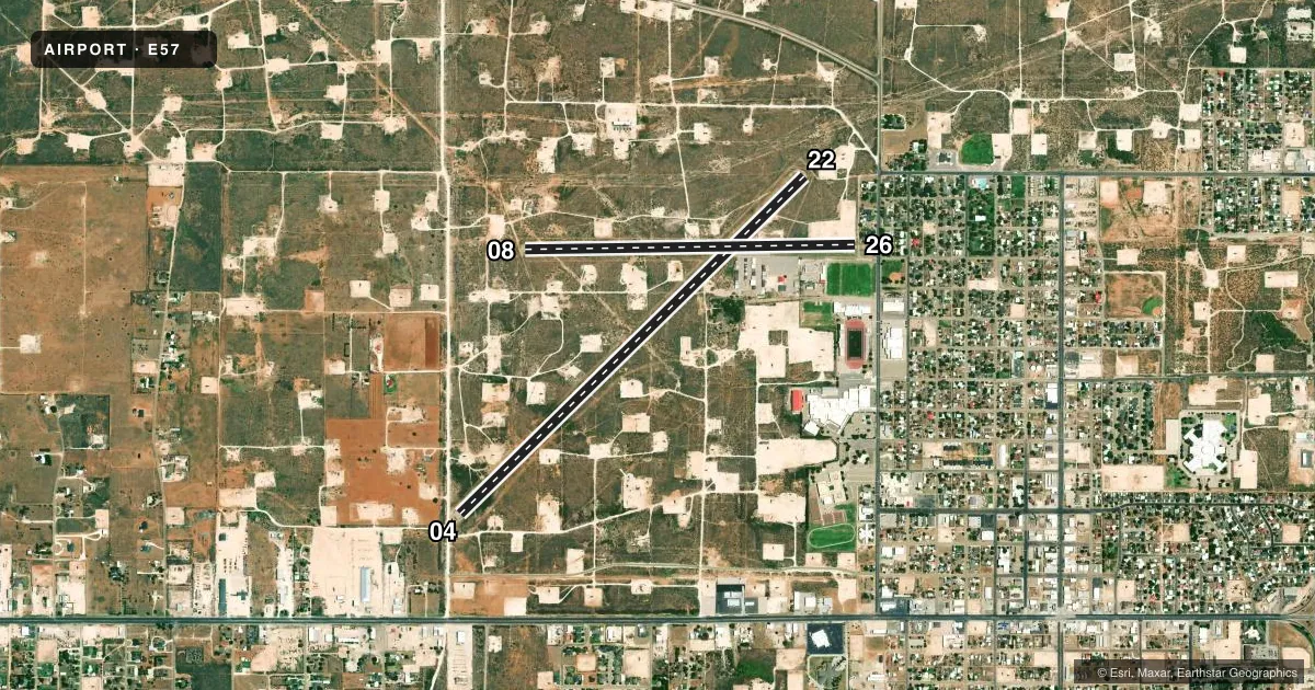
Runways & pattern
Full pagePattern entry · RWY 08
LEFT TRAFFIC| Runway | Heading (°M) | Length | Surface | Traffic |
|---|---|---|---|---|
| 04/22 | 37° / 217° | 5,780 ft | ASPH | 22 R |
| 08/26Favored | 80° / 260° | 3,960 ft | ASPH | 26 R |
Runway end performance
| End | TORA | TODA | ASDA | LDA | VGSI | Approach lights | Obstruction |
|---|---|---|---|---|---|---|---|
| 04 | — | — | — | — | PAPI 2-box left(4.5°) | — | 13', road, 200' from thr, 125' R of cntrln, slope 0 |
| 22 | — | — | — | — | PAPI 2-box left(4°) | — | 6', fence, 201' from thr, 95' R of cntrln, slope 0 |
| 08 | — | — | — | — | — | — | 31', pline, 586' from thr, 165' R of cntrln, slope 12 |
| 26 | — | — | — | — | — | — | 35', pline, 200' from thr, 52' R of cntrln, slope 0 |
Declared distances in feet. TORA = takeoff run available, TODA = takeoff distance, ASDA = accelerate-stop, LDA = landing distance.
Airport sketch
Runways drawn to scale from FAA survey coordinates, rendered over satellite imagery. Not for navigation.
Approaches & charts
Services on the field
Fuel grades, oxygen, maintenance, ramp storage and lighting — as declared to the FAA by the airport operator.
Fuel & services
- Fuel
- 100LLA
- Oxygen (bottled)
- Not available
- Oxygen (bulk)
- Not available
- Airframe repair
- Not available
- Power plant repair
- Not available
- Other services
- AGRI,INSTR
Ramp & ground
- Transient storage
- Tie-down
- Landing fee
- No fee published
- Customs
- Not available
- Lighting schedule
- SS-SR
- Beacon schedule
- SS-SR
- Beacon
- White / Green (civil land)(WG)
- Wind indicator
- Lighted
- Segmented circle
- Yes
Fuel & FBOs
Cheapest 100LL and Jet A on the field and nearby. Always confirm with the FBO before taxi.
Airport notes
Surface conditions, obstructions, local procedures, lighting outages and other notes published with each FAA cycle.
General notes
- RWY 26, ENTRANCE RD & 20 FT HNGRS, INSIDE PRIM SFC.
- LGTD DRILLING RIGS ON & INVOF ARPT.
- FOR CD CTC FORT WORTH ARTCC AT 817-858-7584.
Fuel notes
- 100LLSELF-SERVE.
Approach & departure obstructions
- 044 FT FENCE 0-145 FT DSTC, 125 FT L/R, 13 FT RD, 0-200 FT DSTC.
- 084 FT FENCE 145 FT DSTC, 125 FT L/R.
- 224 FT FENCE, 0-145 FT DSTC, 125 FT L/R.
- 2635 FT PLINE 54 FT DSTC, 84 FT RIGHT.
- 04APCH SLOPE 0:1 AT DSPLCD THR OVR 28 FT POLE, 124 FT R.
- 08APCH SLOPE 24:1 AT DSPLCD THR.
- 22APCH SLOPE 23:1 AT DSPLCD THR.
- 26APCH SLOPE 0:1 AT DSPLCD THR OVR 4 FT FENCE 0 FT DSTC, 74 FT L, 60 FT R.
- 04ALSO 96 FT BLDG, 1266 FT DSTC.
Other notes
- MANAGERCITY/AMGR.
- OWNERPROPERTY LEASED BY CITY AND COUNTY.
VFR map & nearby airports
VFR sectional. Tap any ICAO chip to open that airport.
Key facts · E57
Answer card- ICAO
- E57
- Name
- DENVER CITY
- Location
- DENVER CITY, TEXAS
- Elevation
- 3,575 ft MSL
- Traffic pattern altitude
- 4,575 ft MSL (1,000 AGL)
- Control tower
- Non-towered (use CTAF)
- Total runways
- 2
- Longest runway
- 04/22 · 5,780 ft
- Published ILS approaches
- 0
- Published frequencies
- 2
- Magnetic variation
- 9°
- Current flight rules
- VFR
- Current wind
- 150° at 8 kt
- Favored runway now
- RWY 08
Denver City Airport sits in Denver City, Texas. Field elevation is 3,575 ft MSL. It has two asphalt runways. The longest is runway 04/22 at 5,780 ft. There is no control tower. CTAF and UNICOM are both 122.8. No ILS approaches are published.
Pattern altitude is not published. Use the standard 1,000 ft AGL for light piston traffic unless the current Chart Supplement says otherwise. The airport is on the high plains, so density altitude can matter on warm days. Plan for runway length, climb performance and takeoff roll.
Denver City Airport has one on-field FBO. Denver City Airport carries 100LL and Jet A. 100LL is self-serve. Call (806) 592-3820 for current service details before you go.
Published remarks show several obstructions near the runways. There is a fence near runway 08. Runway 26 has a nearby power line. The entrance road and some hangars sit inside the primary surface. Runway 04 also has fence, road and building notes near the approach area. Runway 22 has a displaced-threshold approach slope note. Treat the field as one that deserves a careful preflight look and a current Chart Supplement check before arrival.