METAR & TAF KBFE
KBFE does not publish a METAR.
Showing the nearest reporting station: KLLN (LEVELLAND MUNI) · 24.5 NM away. Conditions at KBFE may differ.
METAR · KLLN
Observed 18:35Z
KLLN 271835Z AUTO 15012G17KT 10SM CLR 35/13 A3003 RMK AO2
- Wind
- 150° @ 12G17 kt
- Visibility
- 10 SM
- Temp / Dew
- 35°C / 13°C
- Altimeter
- 30.03 inHg
- Clouds
- CLR
- Density alt
- 6,312 ft
- Ceiling
- Unlimited
- Rules
- VFR
Airport info & contacts
Manager on record, flight service, ARTCC, attendance schedule and pattern altitude — published by the FAA and refreshed every 28 days.
Location
- From city
- 4 NM E
- VFR sectional
- ALBUQUERQUE
- ARTCC
- ZFW · FORT WORTH
- NOTAM facility
- FTW (NOTAM-D)
Airport manager
- Name
- HENRY NEUFELD
- Phone
- 432-955-4601
- Address
- 2376 US-380, STE A, BROWNFIELD TX 79316
Flight service · Hours
- FSS FTW
- FORT WORTH1-800-WX-BRIEF
- Attendance
- Unattended
Frequencies
Tap any row to copy the frequency to your clipboard.
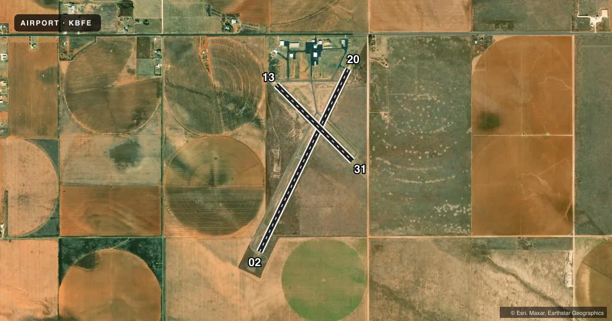
Runways & pattern
Full pagePattern entry · RWY 13
LEFT TRAFFIC| Runway | Heading (°M) | Length | Surface | Traffic |
|---|---|---|---|---|
| 02/20 | 17° / 197° | 5,218 ft | ASPH | Standard L |
| 13/31Favored | 126° / 306° | 2,765 ft | ASPH | Standard L |
Runway end performance
| End | TORA | TODA | ASDA | LDA | VGSI | Approach lights | Obstruction |
|---|---|---|---|---|---|---|---|
| 02 | — | — | — | — | PAPI 2-box left(3°) | — | — |
| 20 | — | — | — | — | PAPI 2-box left(3°) | — | 40', trees, 950' from thr, 110' R of cntrln, slope 18 |
| 13 | — | — | — | — | — | — | 48', pline, 1530' from thr, 275' R of cntrln, slope 27 |
| 31 | — | — | — | — | — | — | 10', road, 410' from thr, 147' R of cntrln, slope 21 |
Declared distances in feet. TORA = takeoff run available, TODA = takeoff distance, ASDA = accelerate-stop, LDA = landing distance.
Airport sketch
Runways drawn to scale from FAA survey coordinates, rendered over satellite imagery. Not for navigation.
Approaches & charts
Services on the field
Fuel grades, oxygen, maintenance, ramp storage and lighting — as declared to the FAA by the airport operator.
Fuel & services
- Fuel
- 100LLA
- Other services
- AGRI,INSTR
Ramp & ground
- Transient storage
- Tie-down
- Landing fee
- No fee published
- Customs
- Not available
- Lighting schedule
- SEE RMK
- Beacon schedule
- SS-SR
- Beacon
- White / Green (civil land)(WG)
- Wind indicator
- Lighted
- Segmented circle
- Yes
Fuel & FBOs
Cheapest 100LL and Jet A on the field and nearby. Always confirm with the FBO before taxi.
Airport notes
Surface conditions, obstructions, local procedures, lighting outages and other notes published with each FAA cycle.
General notes
- FOR CD CTC FORT WORTH ARTCC AT 817-858-7584.
- BIRDS & WILDLIFE ON AND INVOF ARPT.
- RWY 02/20 PARL TWY POOR, EXTSV CRACKS.
Lighting notes
- MIRL RWY 02/20 PRESET LOW INTST; TO INCR INTST ACTVT - CTAF.
Fuel notes
- 100LLFUEL SELF SVC 24 HRS.
VFR map & nearby airports
VFR sectional. Tap any ICAO chip to open that airport.
Key facts · KBFE
Answer card- ICAO
- KBFE
- Name
- TERRY COUNTY
- Location
- BROWNFIELD, TEXAS
- Elevation
- 3,264.6 ft MSL
- Traffic pattern altitude
- 4,264.6 ft MSL (1,000 AGL)
- Control tower
- Non-towered (use CTAF)
- Total runways
- 2
- Longest runway
- 02/20 · 5,218 ft
- Published ILS approaches
- 0
- Published frequencies
- 6
- Magnetic variation
- 9°
- Current flight rules
- VFR
- Current wind
- 150° at 12 kt
- Favored runway now
- RWY 13
Terry County Airport is in Brownfield, Texas. The field elevation is 3,264.6 ft MSL. It has two asphalt runways. The longest is 5,218 ft on runway 02/20. This is an untowered airport, so CTAF and UNICOM are both 122.8. No ILS approaches are published here. The pattern altitude is not published. Use the standard 1,000 ft AGL pattern for light piston traffic unless ATC or the current Chart Supplement says otherwise.
The on-field FBO is Terry County Airport. It carries 100LL and Jet A. Self-serve 100LL is available 24 hours. Birds and wildlife are reported on and near the airport, so keep a sharp scan on arrival and departure. Runway 02/20 has medium intensity lights that default to low intensity. Use the CTAF to step them up if needed. The parallel taxiway for 02/20 is reported in poor condition with extensive cracking, so plan your ground roll and taxi with that in mind.
For IFR work, the published approach and departure frequencies are handled through Lubbock. For clearance delivery, Fort Worth ARTCC is listed in the remarks. Brownfield sits in open West Texas country, so expect a high-density altitude environment in warm weather. Check the current Chart Supplement and the airport operator for any local procedures before you go.