METAR & TAF 18T
18T does not publish a METAR.
Showing the nearest reporting station: KHOB (LEA COUNTY RGNL) · 34.6 NM away. Conditions at 18T may differ.
METAR · KHOB
Observed 12:50Z
KHOB 271250Z 13004KT 10SM CLR 22/14 A3004
- Wind
- 130° @ 4 kt
- Visibility
- 10 SM
- Temp / Dew
- 22°C / 14°C
- Altimeter
- 30.04 inHg
- Clouds
- CLR
- Density alt
- 5,634 ft
- Ceiling
- Unlimited
- Rules
- VFR
Airport info & contacts
Manager on record, flight service, ARTCC, attendance schedule and pattern altitude — published by the FAA and refreshed every 28 days.
Location
- From city
- 3 NM E
- VFR sectional
- ALBUQUERQUE
- ARTCC
- ZFW · FORT WORTH
- NOTAM facility
- ABQ (NOTAM-D)
Airport manager
- Name
- ARNOLD RAMIREZ
- Phone
- 575-398-4633
- Address
- 120 W BROADWAY, P.O BOX 156, TATUM NM 88267
Flight service · Hours
- FSS ABQ
- ALBUQUERQUE1-800-WX-BRIEF
- Attendance
- Unattended
Frequencies
Tap any row to copy the frequency to your clipboard.
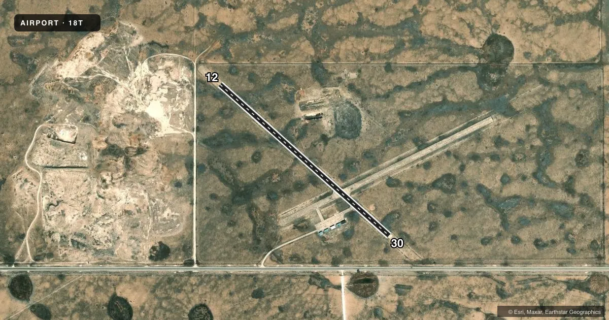
Runways & pattern
Full pagePattern entry · RWY 12
LEFT TRAFFICRunway end performance
| End | TORA | TODA | ASDA | LDA | VGSI | Approach lights | Obstruction |
|---|---|---|---|---|---|---|---|
| 12 | — | — | — | — | — | NSTD | 5', fence, 265' from thr, 135' R of cntrln, slope 13 |
| 30 | — | — | — | — | — | NSTD | 15', road, 400' from thr, 155' R of cntrln, slope 13 |
Declared distances in feet. TORA = takeoff run available, TODA = takeoff distance, ASDA = accelerate-stop, LDA = landing distance.
Airport sketch
Runways drawn to scale from FAA survey coordinates, rendered over satellite imagery. Not for navigation.
Approaches & charts
Services on the field
Fuel grades, oxygen, maintenance, ramp storage and lighting — as declared to the FAA by the airport operator.
Fuel & services
- Fuel
- Not available
Ramp & ground
- Transient storage
- Tie-down
- Landing fee
- No fee published
- Beacon schedule
- SS-SR
- Beacon
- White / Green (civil land)(WG)
- Wind indicator
- Yes
- Segmented circle
- Yes
Fuel & FBOs
Cheapest 100LL and Jet A on the field and nearby. Always confirm with the FBO before taxi.
Airport notes
Surface conditions, obstructions, local procedures, lighting outages and other notes published with each FAA cycle.
General notes
- GATE CODE - FLD ELEV.
- WILDLIFE ON & INVOF OF ARPT.
- FOR CD CTC FORT WORTH ARTCC AT 817-858-7584.
- 6"-12" VEGETATION IN ALL ON ARPT PAVEMENTS; RAMP TIE DOWNS COVERED BY VEGETATION, 2 FT-10 FT SCTRD BRUSH NORTH SIDE TRANSITION AREA.
Lighting notes
- OTS INDEFLY.
Approach & departure obstructions
- 12ODALS OTS INDEFLY; 3 LGTS ON EXTDD CNTRLN; NONSTD SPACING.
- 30ODALS OTS INDEFLY; 3 LGTS ON EXTDD CNTRLN; NONSTD SPACING.
- 12RWY 12 MRKG FADED OR MISSING RED "X" ON NMBR.
- 30RWY 30 MARKING FADED OR MISSING.RED "X" ON RWY NMBR.
Other notes
- 12/30NUMEROUS UNFILLED CRACKS WITH 1 FT VEGETATION.
VFR map & nearby airports
VFR sectional. Tap any ICAO chip to open that airport.
Key facts · 18T
Answer card- ICAO
- 18T
- Name
- TATUM
- Location
- TATUM, NEW MEXICO
- Elevation
- 3,986 ft MSL
- Traffic pattern altitude
- 4,986 ft MSL (1,000 AGL)
- Control tower
- Non-towered (use CTAF)
- Total runways
- 1
- Longest runway
- 12/30 · 2,920 ft
- Published ILS approaches
- 0
- Published frequencies
- 1
- Magnetic variation
- 10°
- Current flight rules
- VFR
- Current wind
- 130° at 4 kt
- Favored runway now
- RWY 12
Tatum Airport (18T) sits in Tatum, New Mexico. The field elevation is 3,986 ft MSL. It has one runway. Runway 12/30 is 2,920 ft long and asphalt. This is a non-towered field. CTAF is 122.9.
No ILS approaches are published here. The pattern altitude is not published, so use the standard 1,000 ft AGL pattern for light piston operations unless the current Chart Supplement says otherwise. Runway headings are 132° and 312° magnetic. That matters here because the field has a 10° magnetic variation.
Published remarks show some items a first-time pilot should plan around. Runway 12 and Runway 30 markings are faded or missing. The approach lighting systems for both ends are out of service indefinitely. A few lights remain on the extended centerline with nonstandard spacing. Wildlife is also present on and near the airport. The gate code is the field elevation. For clearance delivery, contact Fort Worth ARTCC at 817-858-7584.
There are no on-field FBOs listed. Verify fuel and services with the airport operator before you go. In this part of New Mexico, the higher field elevation means performance planning matters. Check density altitude, runway condition and the current Chart Supplement before departure.