METAR & TAF 36K
Current METAR
Observed 13:15Z
K36K 271315Z AUTO 22008KT 10SM CLR 26/14 A2994 RMK AO2
- Wind
- 220° @ 8 kt
- Visibility
- 10 SM
- Temp / Dew
- 26°C / 14°C
- Altimeter
- 29.94 inHg
- Clouds
- CLR
- Density alt
- 5,110 ft
- Ceiling
- Unlimited
- Rules
- VFR
Airport info & contacts
Manager on record, flight service, ARTCC, attendance schedule and pattern altitude — published by the FAA and refreshed every 28 days.
Location
- From city
- 2 NM N
- VFR sectional
- WICHITA
- ARTCC
- ZKC · KANSAS CITY
- NOTAM facility
- ICT (NOTAM-D)
Airport manager
- Name
- KYMBERLY LOGAN
- Phone
- 620-260-0502
- Address
- 1662 RD. T, LAKIN KS 67860
Flight service · Hours
- FSS ICT
- WICHITA1-800-WX-BRIEF
- Attendance
- MON-FRI · 0800-1700
Frequencies
Tap any row to copy the frequency to your clipboard.
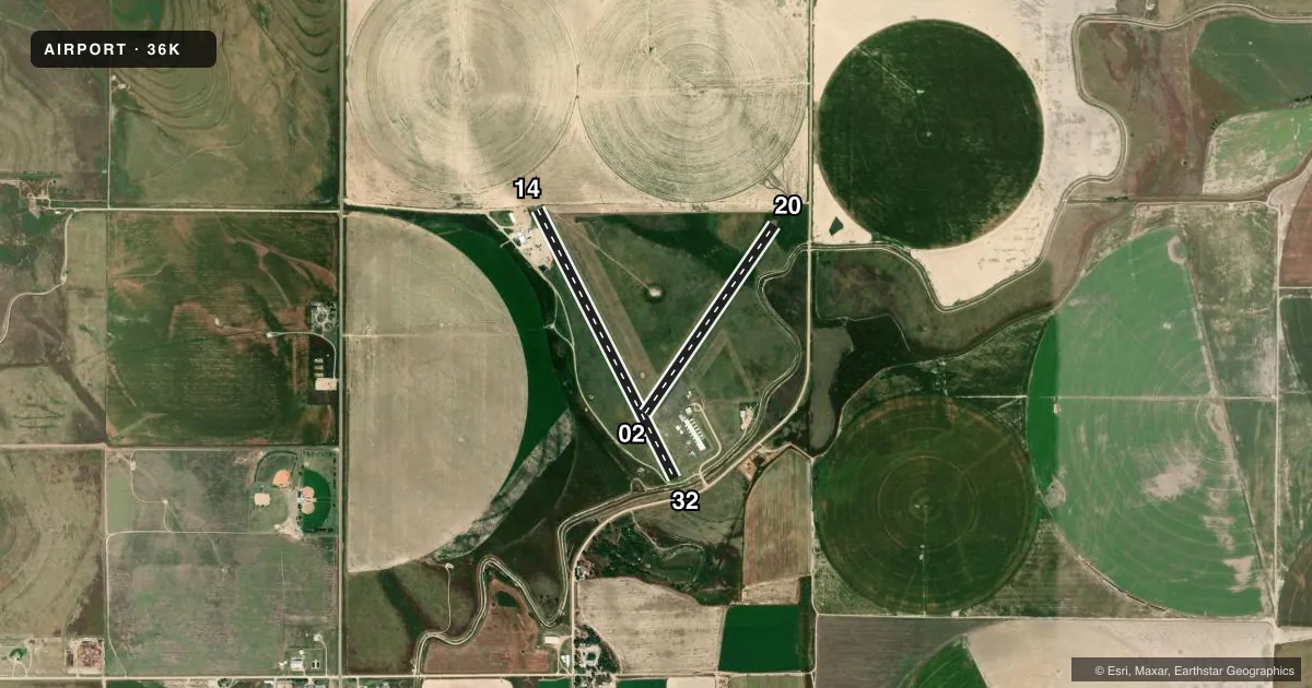
Runways & pattern
Full pagePattern entry · RWY 20
LEFT TRAFFIC| Runway | Heading (°M) | Length | Surface | Traffic |
|---|---|---|---|---|
| 14/32 | 144° / 324° | 3,410 ft | ASPH | Standard L |
| 02/20Favored | 25° / 205° | 2,579 ft | TURF | Standard L |
Runway end performance
| End | TORA | TODA | ASDA | LDA | VGSI | Approach lights | Obstruction |
|---|---|---|---|---|---|---|---|
| 14 | — | — | — | — | — | — | road, slope 50 |
| 32 | — | — | — | — | — | — | 9', road, 201' from thr, 125' R of cntrln, slope 0 |
| 20 | — | — | — | — | — | — | 32', pline, 420' from thr, 100' R of cntrln, slope 13 |
Declared distances in feet. TORA = takeoff run available, TODA = takeoff distance, ASDA = accelerate-stop, LDA = landing distance.
Airport sketch
Runways drawn to scale from FAA survey coordinates, rendered over satellite imagery. Not for navigation.
Approaches & charts
Services on the field
Fuel grades, oxygen, maintenance, ramp storage and lighting — as declared to the FAA by the airport operator.
Fuel & services
- Fuel
- 100LL
- Oxygen (bottled)
- Not available
- Oxygen (bulk)
- Low pressure
- Airframe repair
- Major
- Power plant repair
- Major
- Other services
- AGRI
Ramp & ground
- Transient storage
- Tie-down
- Hangar
- Landing fee
- No fee published
- Lighting schedule
- SS-SR
- Beacon schedule
- SS-SR
- Beacon
- White / Green (civil land)(WG)
- Wind indicator
- Lighted
- Segmented circle
- No
Fuel & FBOs
Cheapest 100LL and Jet A on the field and nearby. Always confirm with the FBO before taxi.
Airport notes
Surface conditions, obstructions, local procedures, lighting outages and other notes published with each FAA cycle.
General notes
- FOR CD CTC KANSAS CITY ARTCC AT 913-254-8508.
Approach & departure obstructions
- 1410 FT RD 0 FT DSTC, 78 FT L ACRS APCH.
- 329 FT RD, 193 FT DSTC, 125 L.
- 14CONTROLLING OBSTRUCTION EXCEEDS A 45 DEGREE SLOPE
Other notes
- EXISTED PRIOR TO 1959.
- 02/20ROUGH & UNEVEN, BARE SPOTS, 6 FT. BERM BOTH SIDES OF RWY, MIDWAY.
VFR map & nearby airports
VFR sectional. Tap any ICAO chip to open that airport.
Key facts · 36K
Answer card- ICAO
- 36K
- Name
- KEARNY COUNTY
- Location
- LAKIN, KANSAS
- Elevation
- 3,076.4 ft MSL
- Traffic pattern altitude
- 4,076.4 ft MSL (1,000 AGL)
- Control tower
- Non-towered (use CTAF)
- Total runways
- 2
- Longest runway
- 14/32 · 3,410 ft
- Published ILS approaches
- 0
- Published frequencies
- 1
- Magnetic variation
- 9°
- Current flight rules
- VFR
- Current wind
- 220° at 8 kt
- Favored runway now
- RWY 20
Kearny County Airport sits in Lakin, Kansas. The field elevation is 3,076.4 ft MSL. It has two runways. The longest is runway 14/32 at 3,410 ft. Runway 02/20 is 2,579 ft turf. There is no control tower. CTAF is 122.9.
No ILS approaches are published here. Pattern altitude is not published, so use the standard 1,000 ft AGL for light piston traffic unless the current Chart Supplement says otherwise. The on-field FBO is Kearny County Airport. It carries 100LL. Call ahead at (620) 260-0502 for current service details.
This is a high-elevation field in southwest Kansas. Expect density altitude to matter on warm days. The published remarks also call out obstructions near runway 14 and runway 32. Runway 14 has a road close to the approach path. Runway 32 has a road off to the left. The turf runway is also published as rough and uneven with bare spots. There is a 6 ft berm on both sides midway down 02/20. If you are new to the airport, plan a careful look at the runway surface before committing. For clearance delivery, contact Kansas City ARTCC at 913-254-8508.