METAR & TAF KGCK
Current METAR
Observed 10:54Z
KGCK 271054Z AUTO 15010KT 10SM CLR 23/15 A2988 RMK AO2 SLP071 T02280150 $
- Wind
- 150° @ 10 kt
- Visibility
- 10 SM
- Temp / Dew
- 23°C / 15°C
- Altimeter
- 29.88 inHg
- Clouds
- CLR
- Density alt
- 4,594 ft
- Ceiling
- Unlimited
- Rules
- VFR
Airport info & contacts
Manager on record, flight service, ARTCC, attendance schedule and pattern altitude — published by the FAA and refreshed every 28 days.
Location
- From city
- 8 NM SE
- VFR sectional
- WICHITA
- ARTCC
- ZKC · KANSAS CITY
- NOTAM facility
- GCK (NOTAM-D)
Airport manager
- Name
- MS. RACHELLE POWELL
- Phone
- 620-276-1190
- Address
- 2225 S. AIR SERVICE RD. 112, GARDEN CITY KS 67846
Flight service · Hours
- FSS ICT
- WICHITA1-800-WX-BRIEF
- Attendance
- 0700-2100
Frequencies
Tap any row to copy the frequency to your clipboard.
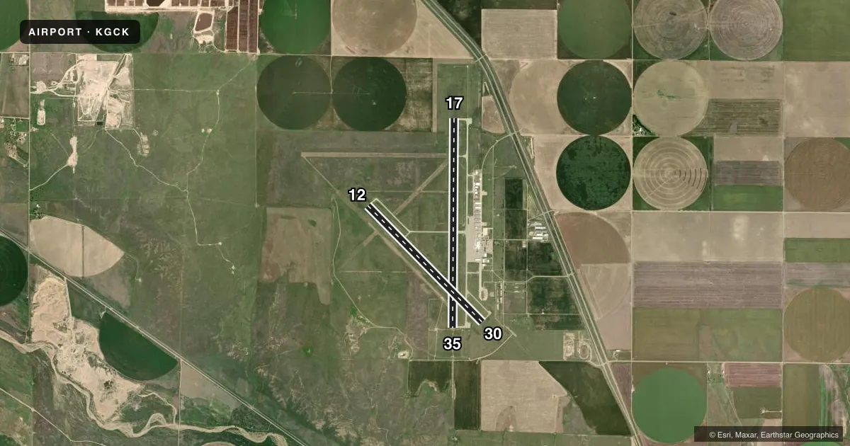
Runways & pattern
Full pagePattern entry · RWY 12
LEFT TRAFFIC| Runway | Heading (°M) | Length | Surface | Traffic |
|---|---|---|---|---|
| 17/35 | 175° / 355° | 7,299 ft | CONC | Standard L |
| 12/30Favored | 130° / 310° | 5,700 ft | CONC | Standard L |
Runway end performance
| End | TORA | TODA | ASDA | LDA | VGSI | Approach lights | Obstruction |
|---|---|---|---|---|---|---|---|
| 17 | 7,299' | 7,299' | 7,299' | 7,299' | VASI 4-box left(3°) | — | — |
| 35 | 7,299' | 7,299' | 7,299' | 7,299' | VASI 4-box left(3°) | MALSR | — |
| 12 | 5,700' | 5,700' | 5,700' | 5,700' | PAPI 2-box left(3°) | — | — |
| 30 | 5,700' | 5,700' | 5,700' | 5,700' | PAPI 2-box left(3°) | — | — |
Declared distances in feet. TORA = takeoff run available, TODA = takeoff distance, ASDA = accelerate-stop, LDA = landing distance.
Airport sketch
Runways drawn to scale from FAA survey coordinates, rendered over satellite imagery. Not for navigation.
Approaches & charts
ILS · 1
Services on the field
Fuel grades, oxygen, maintenance, ramp storage and lighting — as declared to the FAA by the airport operator.
Fuel & services
- Fuel
- 100LLA
- Oxygen (bottled)
- Not available
- Oxygen (bulk)
- Low pressure
- Airframe repair
- Major
- Power plant repair
- Major
- Other services
- AGRI,CHTR,INSTR,RNTL,SALES
Ramp & ground
- Transient storage
- Tie-down
- Hangar
- Landing fee
- No fee published
- Customs
- Not available
- Lighting schedule
- SEE RMK
- Beacon schedule
- SS-SR
- Beacon
- White / Green (civil land)(WG)
- Wind indicator
- Lighted
Fuel & FBOs
Cheapest 100LL and Jet A on the field and nearby. Always confirm with the FBO before taxi.
Airport notes
Surface conditions, obstructions, local procedures, lighting outages and other notes published with each FAA cycle.
General notes
- RY 35 DESIGNATED THE CALM WIND RY.
- AIR CARRIER OPS ARE NOT AUTHORIZED IN EXCESS OF 15 MINUTES BEFORE OR AFTER SCHEDULED ARRIVAL/DEPARTURE TIMES WITHOUT PRIOR COORDINATION WITH AMGR AND CONFIRMATION THAT ARFF IS AVBL PRIOR TO LDNG OR TKOF.
- IN THE EVENT OF AN AIR CARRIER DIVERSION OR OTHER IRREGULAR OPERATIONS EVENTS, AIRCRAFT OPERATORS SHOULD CONTACT AMGR 620-290-3810. FACILITY CONSTRAINTS INCLUDE: LACK OF INTERNATIONAL PASSENGER PROCESSING FACILITIES, LIMITED NUMBER OF PARKING POSITIONS AND LIMITED TERMINAL SPACE FOR PASSENGERS.
- ATCT BLIND SPOT ON THE NORTH TWY A HOLD BAY.
- FOR CD IF UNA TO CTC ON FSS FREQ, CTC KANSAS CITY ARTCC AT 913-254-8508.
Lighting notes
- ACTVT MIRL RY 12/30 & HIRL RY 17/35; REIL RYS 17; 12; 30 & MALSR RY 35 - CTAF. PAPI RYS 12 & 30 AND VASI RYS 17 & 35 ON 24 HRS.
Fuel notes
- 100LLFOR MILITARY FUEL CALL 620-275-5055.
Runway surface & condition
- 12/30PCR VALUE: 290/R/D/W/T
- 17/35PCR VALUE: 270/R/D/W/T
Other notes
- CLSD TO UNSKED ACR OPNS WITH MORE THAN 30 PSGR SEATS EXCP PPR 48 HRS CALL AMGR (620) 276-1190/(620) 290-3810. ARFF INDEX B PROVIDED.
- 1FOR SVC AFTER HRS CALL 620-275-5055.
- MANAGEREMAIL: RACHELLE.POWELL@GARDENCITYKS.US
- MANAGERFAX 620-276-1192
VFR map & nearby airports
VFR sectional. Tap any ICAO chip to open that airport.
Key facts · KGCK
Answer card- ICAO
- KGCK
- Name
- GARDEN CITY RGNL
- Location
- GARDEN CITY, KANSAS
- Elevation
- 2,890.8 ft MSL
- Traffic pattern altitude
- 3,890.8 ft MSL (1,000 AGL)
- Control tower
- Towered · 0700-2100
- Total runways
- 2
- Longest runway
- 17/35 · 7,299 ft
- Published ILS approaches
- 1
- Published frequencies
- 6
- Magnetic variation
- 5°
- Current flight rules
- VFR
- Current wind
- 150° at 10 kt
- Favored runway now
- RWY 12
Garden City Rgnl sits in Garden City, Kansas. Field elevation is 2,890.8 ft MSL. The airport has two concrete runways. The longest is runway 17/35 at 7,299 ft. Runway 12/30 is 5,700 ft. The tower is open from 0700 to 2100. Runway 35 has the ILS. Pattern altitude is not published, so use the standard 1,000 ft AGL for light piston traffic unless ATC or the current Chart Supplement says otherwise.
Crosby Flying Services is on the field. It carries 100LL and Jet A Prist. Call (620) 275-5055 for service after hours or for current fuel and ramp details. The published remarks also note that runway 35 is the calm wind runway. Lighting is good to know here. Runway 17/35 has high intensity lights. Runway 12/30 has medium intensity lights. PAPI is on 12 and 30. VASI is on 17 and 35. The approach lighting for runway 35 is controlled by CTAF.
This is a towered field with a long runway and a high plains elevation. Expect to pay attention to density altitude, especially on warm days. Check the current Chart Supplement for any noise or curfew restrictions before flying into the field. If you are planning an air carrier or irregular operation, coordinate ahead with the airport manager.